Notice of Burwood Local
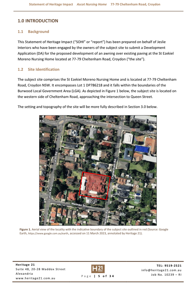
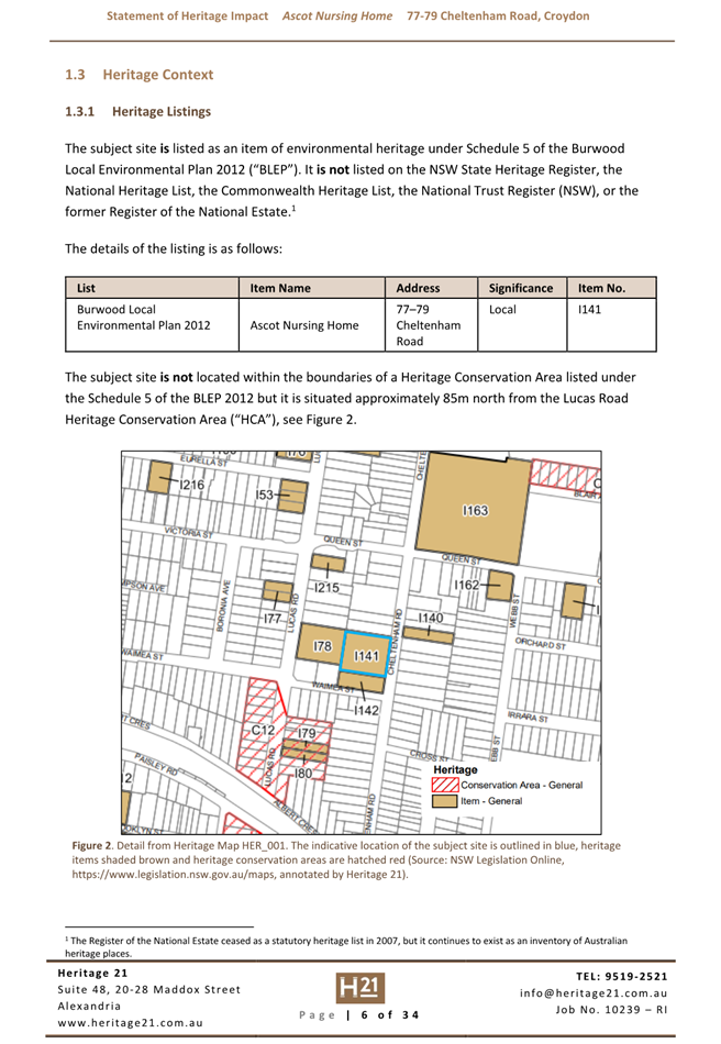
Planning Panel Meeting
The meeting of the Burwood Local
Planning Panel will be held at Conference Room, 2 Conder Street, Burwood on Tuesday
17 September 2024 at 6:00 PM to consider the matters contained in the attached
Agenda.
Tommaso Briscese
General Manager
Agenda
For a Notice of Burwood
Local Planning Panel Meeting of Burwood Council to be held in the Conference
Room, Level 1, 2 Conder Street, Burwood on Tuesday 17 September 2024
immediately after the Public Forum commencing at 6.00pm.
Welcome to the meeting of the Burwood Local Planning
Panel
I declare the Meeting opened at
1. Acknowledgement
of Country
I would like to acknowledge the Wangal
people of the Eora Nation who are the traditional custodians of this land. I
would also like to pay respect to their elders, both past and present, and
extend that respect to other First Nations People who may be present.
2. Introduction
of Panel Members
3. Recording of
Meeting
Members of the public are
advised that Meetings of the Panel are audio recorded for the purpose of
assisting with the preparation of Minutes and the recording of the public part
of the meeting will be published on Council’s website.
4. Explanation
of how the panel will operate
The Panel has undertaken site
investigations and we have before us reports provided by Burwood Council
officers on the matters for consideration.
All members of the public who
have registered to speak will have the opportunity to address the panel. I will
invite you to speak and commence by stating your name and address or whom you
represent.
After all speakers have been
heard, the panel will adjourn to deliberate on the matter.
The Panel will make determinations
on the matters before it. Each determination will include reasons for the
determination, and all such details will be included in the official record of
the meeting.
5. Apologies/Leave
of Absences
6. Declarations of
Interest by Panel Members
7. Chair
introduction of Agenda Item
8. Council
Officer Overview
9. Development
Applications
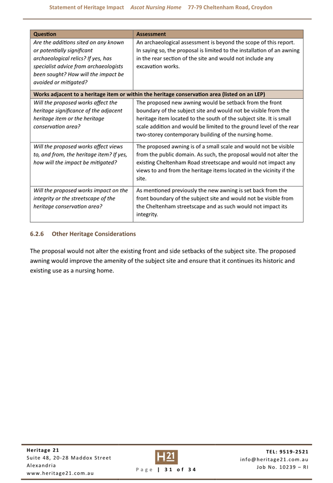
(Item DA9/24) Planning
Assessment Report - 24 Burleigh Street Burwood - DA.2024.33 4
(Item DA10/24) Planning
Assessment Report - 77-79 Cheltenham Road, Croydon - DA.2024.34.............................................................................................. 54
10. General
Business
(Item GB3/24) Disclosure
of pecuniary interests by Burwood Local Planning Panel Members 112
(Item GB/24) Delegation
of Functions from Burwood Local Planning Panel to Council Officers, Minor
Heritage Works and Modifications [Late Report]
Burwood
Local Planning Panel Meeting 17 September 2024
Development Applications
(Item DA9/24) Planning Assessment
Report - 24 Burleigh Street Burwood - DA.2024.33
File No: 24/36659
Report by Senior Town Planner
Owner: Jong
Boronia Pty Ltd
Applicant: Lashta
Haidari
Location: 24
Burleigh Street, Burwood
Zoning: MU1
Mixed Use
Proposal
Internal fit-out and use of
heritage-listed former police station building as a dental practice, provision
of a new accessible entry, minor external works to the building and associated
landscape works.
The proposal is described in
detail below:
Use of the former police
station building as a dental practice
· The
application proposes to use the locally heritage-listed former police station
building as a dental practice.
Internal fit-out to facilitate the use as a dental practice,
including:
· Partial
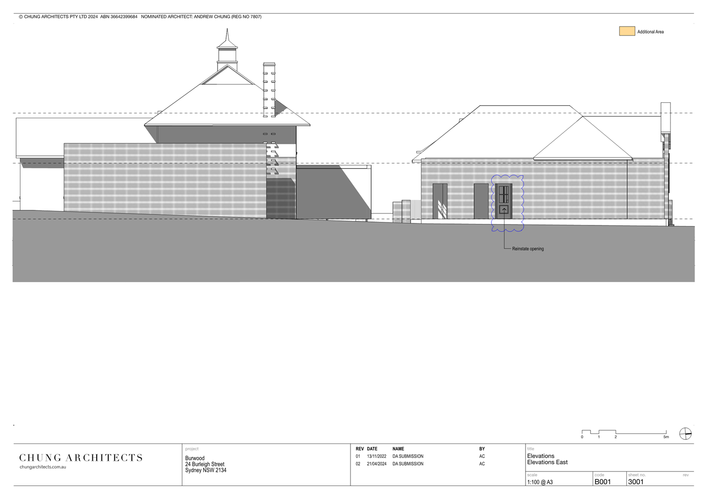
demolition of sections of select internal walls and openings;
· Creation
of new internal doorway openings and reinstatement of original external
opening;
· Addition
of new internal partition walls;
· Addition
of new internal fixtures including services and moveable furniture.
Minor external works to the
building, including:
· Sheeting
over of select existing external doorway openings;
· Re-instatement
of an external door on the eastern elevation of the building
Associated landscaping
· Landscaping
works associated with the construction of the new accessible entry, including
the provision of a planter box along the Burleigh Street boundary parallel with
the street frontage.
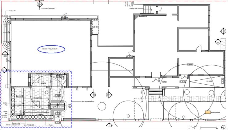

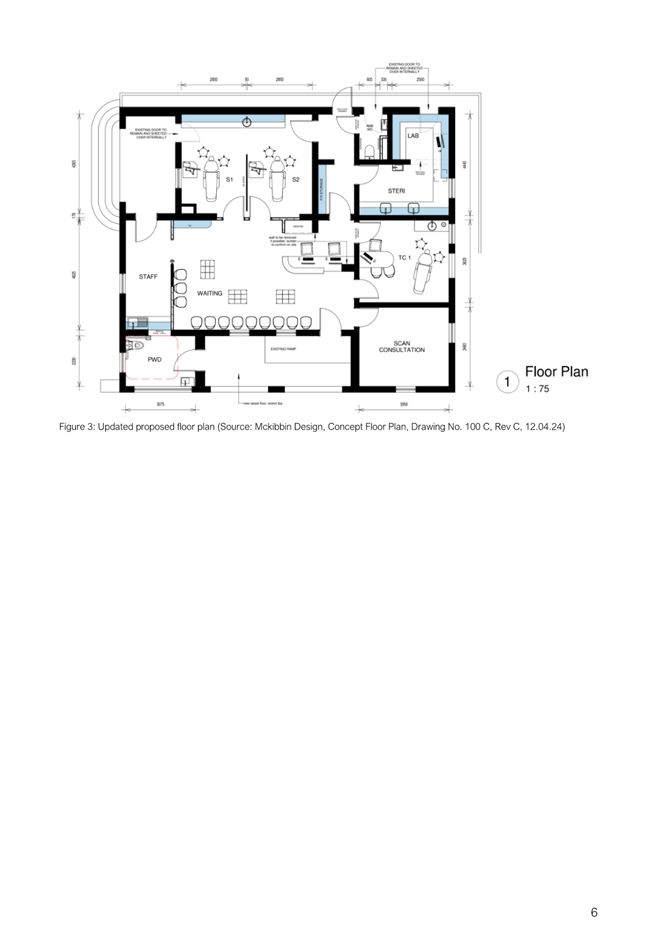
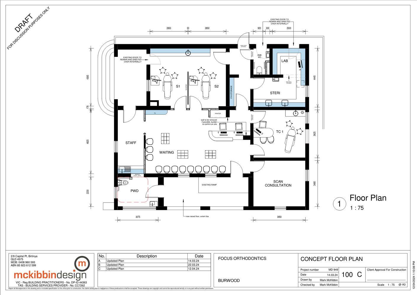
Figure
2: Floor Plan of the proposed internal fit-out. Source: Chung
Architects.
Operational
details of the proposed dental practice are provided below:
Staffing Numbers and Hours of Operation
· Hours
of Operation – 8.30am to 6.30pm – Monday to Saturday.
· Staffing
Numbers - One (1) dental practitioner plus up to two (2) support staff, at any
one time.
Business identification signage
The development application does not propose any new signage or
signage structures.
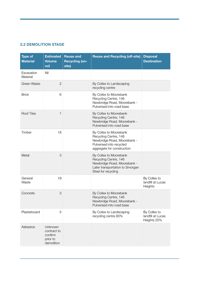
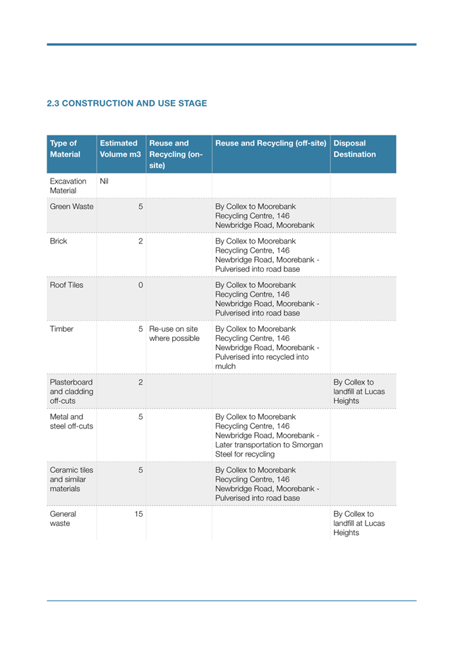
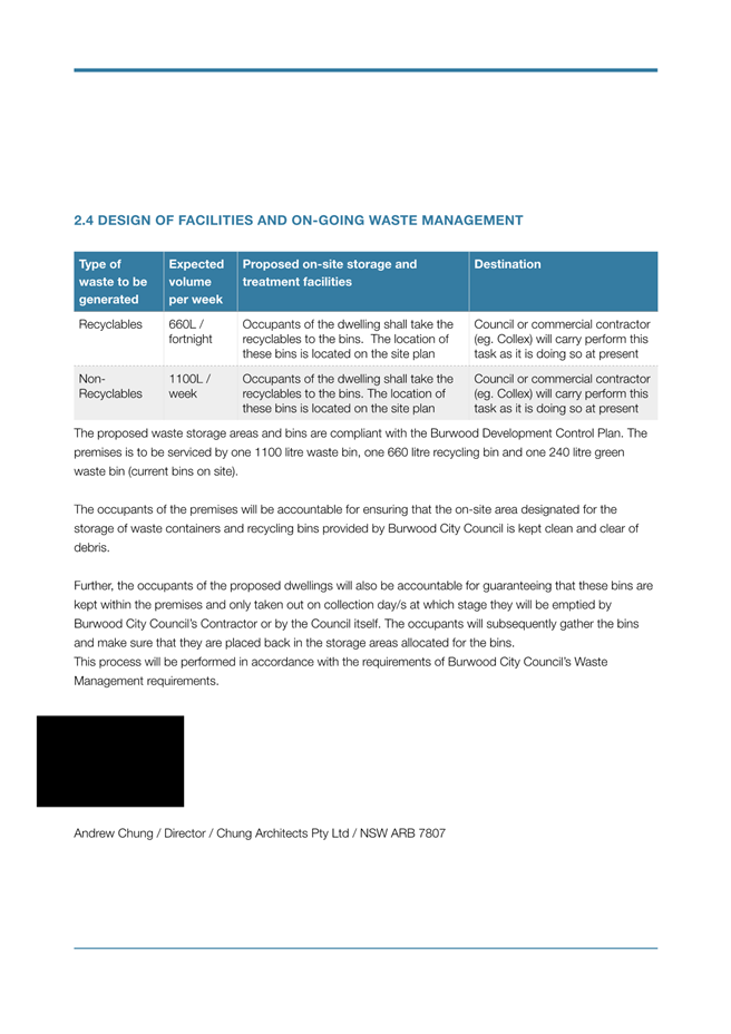
Ongoing waste management
The applicant submitted a waste management plan (prepared by Andrew
Chung of Chung Architects Pty Ltd) with the application which details how waste
will be managed during construction works and on an on-going basis during the
operation of the dental practice.
The proposal provides a designated garbage and recycling bin storage
area at the rear of the premises and accessed from the driveway from Elizabeth
Street, with space for two (2) x 1100 litre bins.
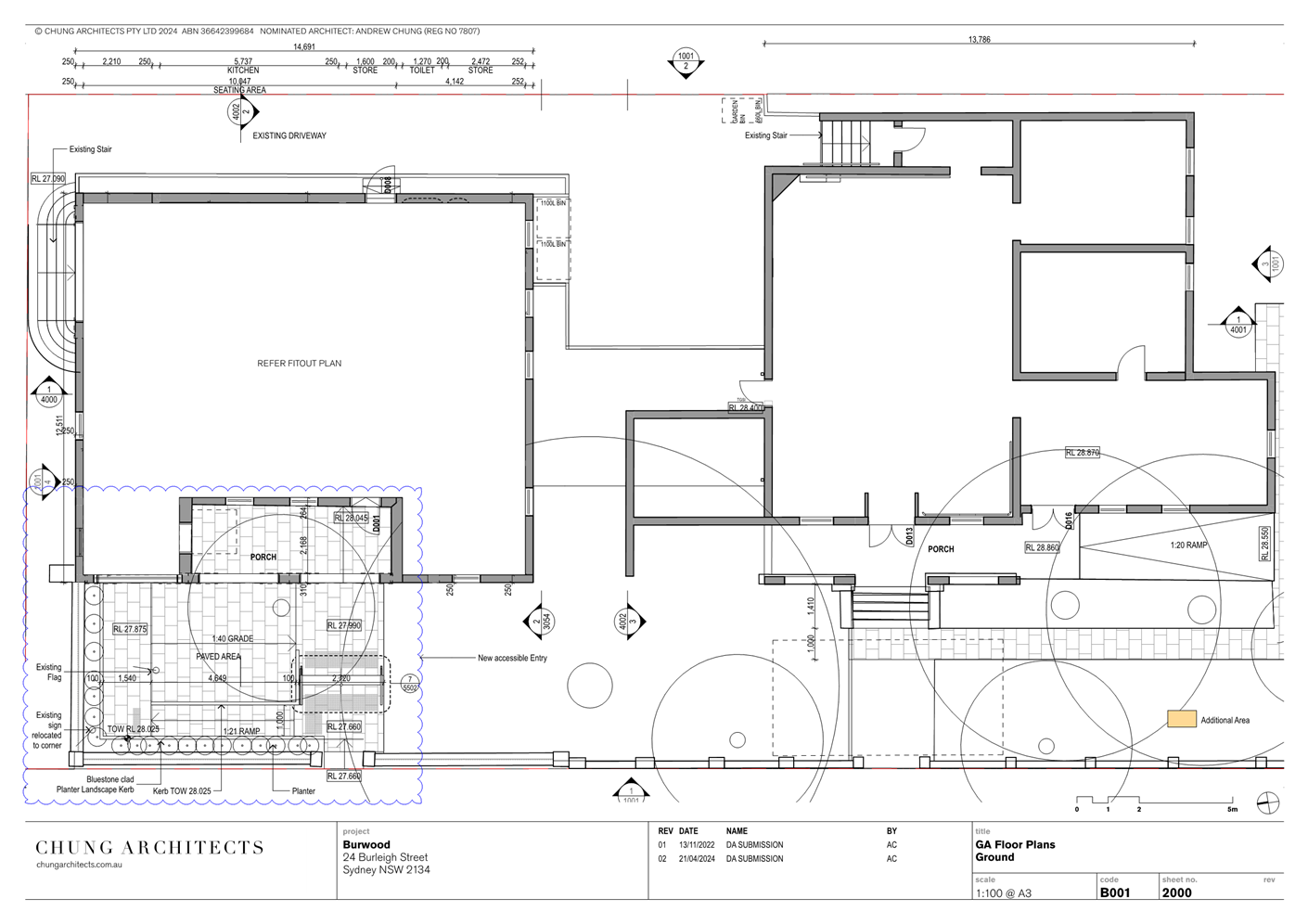
Access to the site
The building currently provides pedestrian access from Burleigh
Street and vehicular access from Elizabeth Street. The application proposes the
construction of a new ‘accessible’ pedestrian entry at the Burleigh
Street frontage of the building.
Parking arrangements
The proposal does not seek to make any changes to existing off-street
car parking arrangements on site. The proposal provides off street car parking
on site within a hardstand car parking area in the middle of the site and in a
stacked arrangement in the driveway.
BLPP Referral Criteria
The building is a local heritage
item and the development involves partial demolition of sections of select
internal walls and openings.
Background
On 3 May 2023 Council approved development application no.
DA.2022.101 for Alterations and additions to commercial development
including internal fit-out for use as a Dental practice and Café and
alteration of existing paved area for outdoor dining including the provision of
disabled access. However, no related construction certificate or notice of
commencement have been issued and the consent has not been acted on.
The most recent previous use of the premises was that of a
barrister’s chambers. The premises is currently vacant.
Statutory Requirements
Heads of Consideration
The application is assessed under
the provisions of Section 4.15 of the Environmental Planning and Assessment Act
1979 (EP&A Act), as amended, which include:
· State
Environmental Planning Policy (Resilience and Hazards) 2021 - Chapter 4
Remediation of land
· The provisions of
the Burwood Local Environmental Plan (BLEP) 2012
· The provisions of
the Burwood Development Control Plan (BDCP) 2013 as amended
· The regulations
(of the EP&A Act)
· The likely social,
environmental and economic impacts of the development
· The suitability of
the site for development
· The public
interest, and
· Submissions made
under the Act and Regulations
These matters are considered in this report.
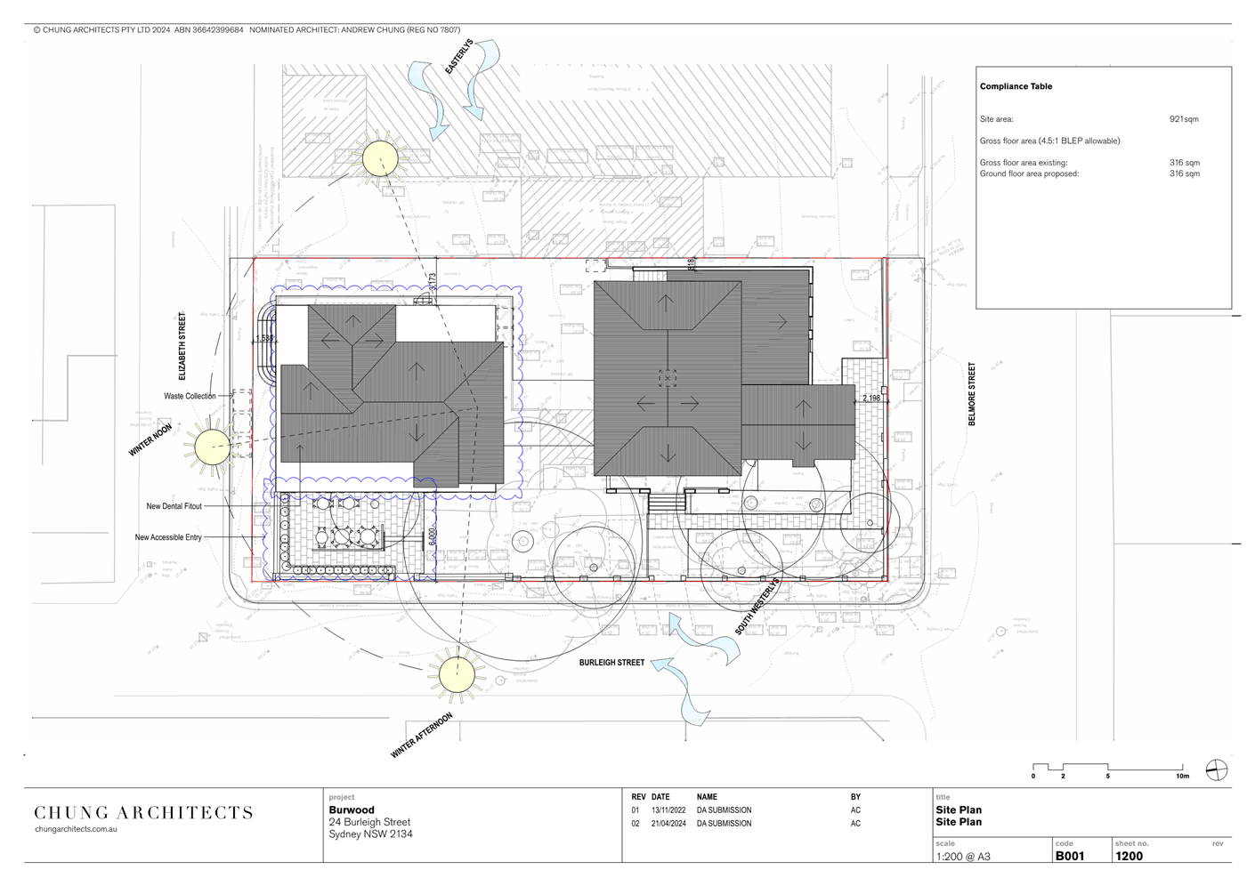
Locality
The location of the subject site is depicted in Figures 3
and 4 below:
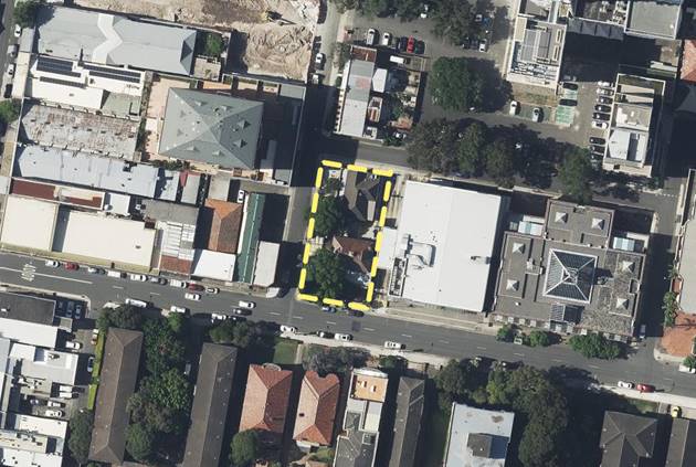
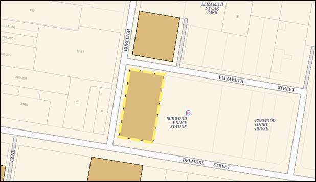
Figure
3: Aerial view of the subject site Lot 11,
DP1168986, at No. 24 Burleigh Street, Burwood (indicated with the
yellow dashed lines). Source: NSW Planning Portal (2024).
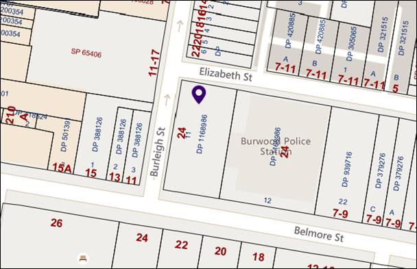
Figure
4: Street map showing the subject site indicated with the
purple marker. Source: Council mapping system.
The subject site is identified as No. 24 Burleigh Street, Burwood NSW
2134 (Lot 11 DP1168986). The site is a corner allotment situated within the
Burwood Town Centre, approximately 100 metres to the east of Burwood
Road. The site has three (3) street frontages, including to Burleigh
Street, Belmore Street and Elizabeth Street. The dimensions of the allotment
(according to the submitted survey plan) are as follows:
· 42.595m
(Burleigh Street frontage, west).
· 21.665m
(Belmore Street frontage, south).
· 21.670m
(Elizabeth Street frontage, north).
· 42.465m
(rear boundary (no street frontage), east).
In terms of topography the site has a slight fall from east to west,
and also from south to north.
Currently occupying the site are the heritage-listed buildings
identified as the [former] Burwood Police Station and Courthouse
(Significance: Local) in Schedule 5, Part 1 Heritage items of the Burwood
Local Environmental Plan 2012. The former police station and courthouse
were constructed as separate buildings but they have since been linked by an
external awning structure. The buildings are listed as a single heritage item.
The courthouse component is located towards the southern end of the site on the
corner of Burleigh and Belmore Streets, and the police station component is
located at the northern end of the site on the corner of Burleigh and Elizabeth
Streets. Records indicate that the police station was constructed in 1897-98,
whereas the courthouse was constructed later in 1899-90.
Vehicular access to the site is provided via an existing driveway
along the eastern boundary of the site which provides access to a small
at-grade parking area in the middle of the site. The southern and western
setback areas of the site are provided with external paving and soft
landscaping, and there are a number of mature trees around perimeter. There is
also a low brick, sandstone and wrought iron boundary fence around western and
southern boundaries of the site. In addition, there is a flagpole and a
freestanding square lightbox sign standing at the at the north-western corner
of the site that remain from when the building was used by the police.
Existing pedestrian entries to the building are from Burleigh Street
and Elizabeth Street, and are clearly visible from each street frontage.
There are nearby heritage items located
directly opposite the site at 12-22 Burleigh Street identified as Victorian
Terraces (Significance: Local) [which are attached terrace houses], and
across the road to the south at 24 Belmore Street identified as Orontes
& Monterey Significance: Local [which are residential flat buildings].
Figure
5: Heritage extract showing the subject site (indicated with
yellow dashed lines) containing a heritage item, identified as ‘Burwood
Police Station and Courthouse (Significance: Local)’ in Schedule 5, Part
1 Heritage items of the BLEP 2012. Source: NSW Planning Portal (2024).
The site is not a flood identified property
in Council’s flood mapping. The land use zoning for the site is MU1 Mixed
Use under the provisions of the Burwood Local Environmental Plan 2012.
Surrounding the site is a variety of
commercial and residential development that is typical of the Burwood Town
Centre. To the east is the new Burwood police station and courthouse complex
facing Belmore Street, to the south is a row of heritage-listed terrace houses
facing Burleigh Street, to the west are two storey commercial buildings facing
Belmore Street and a multi-storey mixed-use commercial and residential building
facing Burleigh Street, and to the north are residential flat buildings facing
Belmore Street ranging from two to five storeys in height.
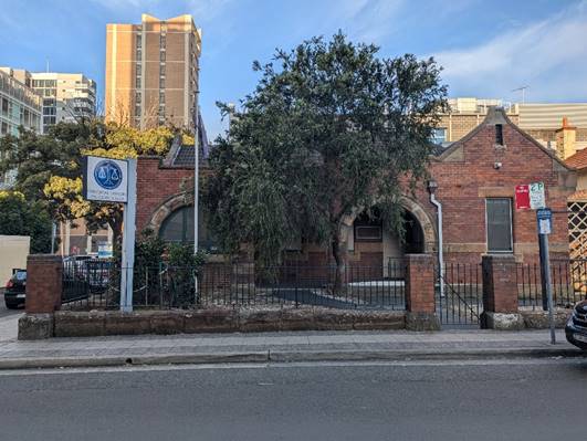
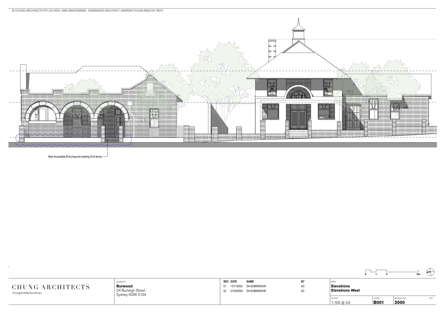
Figure
6: The western facade of the former police station building, as
viewed from Burleigh Street. Source: Alastair Sim (2024).
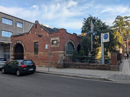
Figure
7: The northern facade of the former police station building,
as viewed from Elizabeth Street. Source: Alastair Sim (2024).
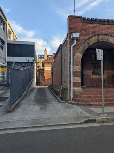
Figure
8: Driveway access to the site, as viewed from Elizabeth
Street. Source: Alastair Sim (2024).
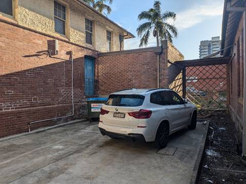
Figure
9: Existing car parking area in the middle of the site,
accessed via the driveway from Elizabeth Street. Source: Alastair Sim (2024).
Planning Assessment
State Environmental Planning Policy (Resilience and
Hazards) 2021 – Chapter 4 Remediation of land
The provisions of SEPP
(Resilience and Hazards) 2021 are required to be considered for any development
application. Consideration must be made if the land is suitable for the
proposed development, if it is contaminated, if it is suitable for the proposed
use, and/or of the contamination is required to be remediated before the land
is used for that purpose.
Considering
the previous use of the site for commercial purposes and as a former police
station, and that a search of Council’s records and a site inspection
revealed no obvious land contamination, given the nature of the proposed
development a land contamination assessment is not considered necessary in this
instance.
Burwood Local Environmental Plan (BLEP) 2012
The BLEP 2012 came into effect on
9 November 2012 and contains a number of controls including development
standards which apply to the proposed development. A summary of the assessment
of the application against the relevant planning controls within the BLEP 2012
is shown below.
Permissibility of the development in the zone
Land Use Zone: MU1 Mixed Use.
Proposal: The proposed use development is for a
dental practice, a form of ‘medical centre’, which is permitted in
the MU1 Mixed Use zone with consent.
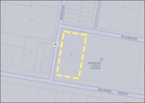
Figure
10: Zoning extract showing the subject site (indicated with
yellow dashed lines) within the MU1 Mixed Use zone. Source: NSW Planning Portal
(2024).
Compliance with relevant BLEP development standards
|
BURWOOD
LEP 2012 – COMPLIANCE WITH DEVELOPMENT STANDARDS
|
YES
|
NO/NA
|
COMMENTS
|
|
4.1
Minimum Lot Size
|
|

|
No subdivision of land proposed. N/A
|
|
4.3 Height
of Buildings
|
|
|
Maximum Permissible Height: 60m.
Height of the proposed works: No change to existing building
height. All works are at ground floor level and are well below 60m in
height.
|
|
4.4 Floor
Space Ratio (FSR) and 4.4A(2) 4.4A Exceptions to floor space
ratio
|
|
|
Maximum FSR: 4.5:1.
Proposed FSR: No change to gross floor area proposed. The
internal fit-out will utilise existing floor space. The current floor space
ratio of the site shall remain well below 4.5:1.
|
|
5.10 Heritage Conservation
|
|
|
The site is not located within
a heritage conservation area or draft heritage conservation area. However, the site does contain a local heritage item identified as the Burwood Police Station and
Courthouse (Significance: Local) in Schedule 5, Part 1 Heritage
items of the BLEP 2012.
There
are also nearby heritage items located on the opposite the site at 12-22
Burleigh Street known as Victorian Terraces Significance: Local) [which
are attached terrace houses] and across the road to the south at 24
Belmore Street known as Orontes & Monterey Significance: Local [which
are residential flat buildings].
The
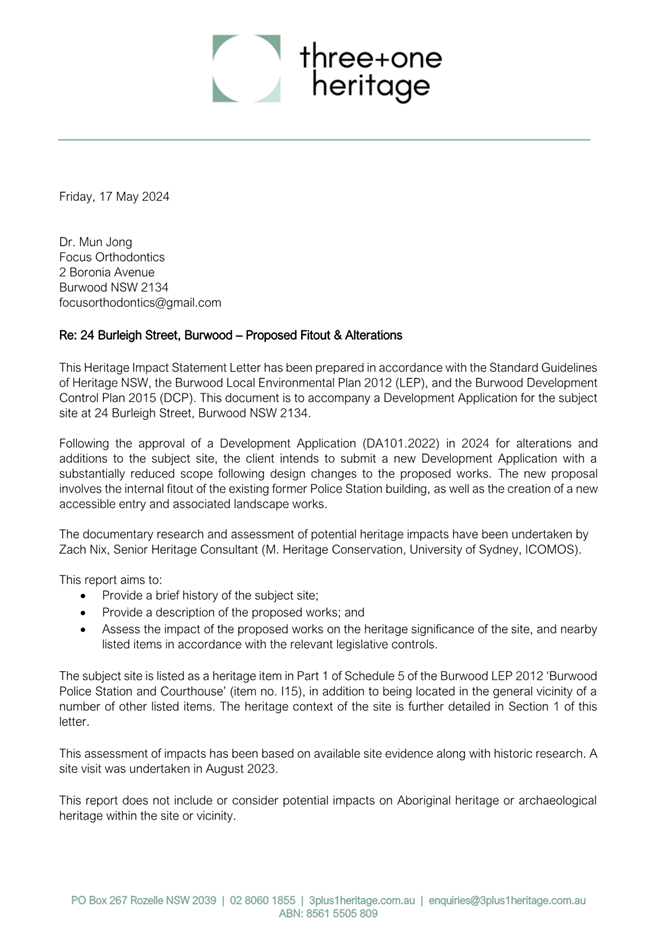
application proposes building works to and use of the former Burwood Police
Station. The applicant submitted a Heritage Impact Statement Letter, prepared
by Zach Nix of - Three + One Heritage, with the proposal. Accordingly, the
application was referred to Council’s consultant Heritage Advisor for
review and comment, who raised no objections to the proposal provided that
appropriate heritage conditions of approval be imposed. The application
therefore is considered to satisfy Clause 5.10 of the Burwood LEP 2012.
Please refer to Attachment
1 to view the applicant’s heritage impact statement and Attachment
2 to view Council’s heritage advisor’s referral memo.
|
|
6.1 Acid
Sulfate Soils
|
|
|
Is the proposal affected by acid sulfate soils?
Comment: The land is classed as having Class
5 acid sulfate soils - meaning there is low chance of acid sulfate within the
soil which can impact development. Minimal excavation is required to carry
out the development. No acid sulfate soil management report is considered to be
required.
|
|
6.2 Flood
Planning
|
|
|
Is the property a flood identified property?
Comment: No.
|
|
6.3
Active Street Frontages
|
|
|
Do
BLEP 2012 Active Street Frontage provisions apply to the site?
Comment:
No.
|
Burwood Development Control Plan (BDCP) 2013 as
amended
The Burwood Development Control
Plan 2013 (BDCP) applies to the proposed development. A summary of the
assessment of the application against the relevant objectives and provisions
within the BDCP is shown below.
|
BURWOOD
DCP – COMPLIANCE WITH OBJECTIVES & PROVISIONS
|
YES
|
NO
|
COMMENTS
|
|
Part 2 – Site & Environmental
Planning
|
|
|
Part
2.2 Site Analysis: As the development consists of a ‘change of
use’ and relatively minor alterations and additions the BDCP does not
require the submission of a detailed site analysis.
Part
2.3 Views and Vistas: The proposal does not interfere or compromise any
significant views of vistas.
Part
2.4 Streetscape: The proposal includes minor alterations to the exterior
of the building including the provision of a new accessible entry. The
building is currently vacant and its use will improve local amenity. No
unreasonable or adverse impacts on the existing streetscape are expected.
|
|
Part 3.2 – General Building Design
Controls in Centres and Corridors
|
|
|
Part 3.2.4 Street-Front
Activities and Building Access
Provision: P2 Ground
floor level development must:
· Promote
quality non-residential activities in accordance with the zone.
· Minimise
the number of service doors.
· Encourage
visual interest on service doors with displays etc.
· Provide
access points to and from the public domain at not more than 20 metre
intervals.
· Provide
at-grade access at entry points.
· Incorporate
visually interesting streetscape frontages at ground level with attractive
entries, clear glazed windows and window displays, artworks, articulated
architecture and facade modulation.
Proposed: The proposal
provides commercial street activation and is a quality non-residential use
located at street level within the Burwood Town Centre.
No new street-facing service
doors are proposed to the heritage-listed building. Pedestrian entry to the
building will be clearly delineated and easily visible from the public
domain. The application proposes to construct a new ‘accessible’
pedestrian entry at the Burleigh Street frontage of the building.
The dental practice will be
located within a heritage-listed building that will retain its heritage
qualities.
Provision: P3 Separate
and clearly identifiable entrances must be provided from the street for
pedestrians
and cars, and different uses
(residential and non-residential).
Proposed: The pedestrian
entry is clearly delineated and separate from the vehicular entry to the
site.
Provision: P4 Building
entrances must have a direct physical and visual connection with the street.
Proposed: The building
entry has a direct physical and visual connection with the street and will be
enhanced via the provision of an ‘accessible’ entry.
Provision: P7 All
commercial components must have a clear street address.
Proposed: The street
address, being No. “24” Burleigh Street is currently provided
fixed to the existing front fence.
Provision: P15
Mechanical ventilation and plant equipment must not be visible from the
public domain, or be attached to the external façades or elevations.
It must be located within a central plant area and screened from public view,
and, P16 Mechanical ventilation and plant equipment must not adversely
affect the architectural quality and presentation of façades,
elevations or roof features.
Proposed: Condition of
approval to be imposed to ensure that no external mechanical ventilation and
plant equipment is installed without the prior approval of Council,
considering that the building is a heritage item.
3.2.18 Safety and
Security
Objective: To ensure
development is safe and secure for occupant’s visitors and other users
at all times.
Proposed:
No objection is raised to the proposed development in regards to safety
and security. The proposal is for a dental practice within an existing
heritage-listed building. It is noted that the site is located adjacent to a
working police station.
Provision:
P9 Fully enclosed roller shutters are not permitted to shop fronts or
other business premises. Retractable open security grilles may be considered.
Proposed:
No new roller shutters or open security grilles are proposed.
Provision:
P10 Security bars, roller shutters or fixed grilles visible from the
public domain on any commercial, retail or business premises are prohibited.
Proposed:
No new security bars, roller shutters or fixed grilles visible from the
public domain are proposed.
3.2.19
Access and Mobility
Provision:
P1 The main entry of development must be designed and identified for use
by persons with a mobility impairment
Proposed:
The proposal provides a new ‘accessible’ pedestrian entry at
the Burleigh Street frontage of the building for use by persons with a
mobility impairment.
Provision:
P2 The main entry must be accessible from the street footpath in
accordance with Australian Standard (AS) 1428: Design for Access and Mobility
Proposed:
As noted, the proposal provides a new accessible entry to the premises at the
Burleigh Street frontage of the building. Condition of approval shall be
imposed to ensure that all works comply with applicable Australian Standards.
Provision:
P3 Safe and convenient access must be provided in all development, car
parks and communal facilities.
Proposed:
The proposal provides safe and convenient access to the site from the
public domain for both vehicles and pedestrians.
Provision:
P4 Compliance with AS 1428.1 is required with respect to access
requirements on new building work.
Proposed:
Condition of approval shall be imposed to ensure that all works comply
with applicable Australian Standards..
|
|
Part 3.3 – Area Based Controls –
Burwood Town Centre and Burwood Road North
|
|
|
Objective: The site is
located within the Burwood Town Centre “Middle Ring Area” (shown
in Figure 18 on page 59 of the Burwood DCP). The aims for the Burwood Town
Centre and the contiguous Burwood Road North area are:
· To
provide for a vibrant centre with a level of amenity that reflects its Major
Centre status.
· To
provide for a built form that supports appropriate urban design outcomes
· To
ensure a building scale that complements existing heritage items and
human-scale streetscape environments.
Proposed: The proposed
fit-out and use of the building as a dental practice is consistent with these
aims.
|
|
Part
3.9 - Transport and Parking in Centres and Corridors
|
|
|
Minimum car parking requirement: The BDCP requires that at
least four (4) car parking spaces be provided on site for the purpose of a
medical centre, including 4 spaces per health care professional (doctor,
dentist or other) being 1 space for the health care professional, 1 space for
an employee and 2 spaces for patients.
Proposed: The proposal does not seek to make any physical
changes to existing off-street car parking arrangements. The proposal
provides at least four (4) on site car parking spaces within an existing car
parking area and driveway, which is considered adequate for the proposed use
considering the central location of the site within the Burwood Town Centre.
Furthermore, there is a public carpark located to the rear of the site
accessed from Elizabeth Street.
|
|
Part
6.1 - Tree Preservation
|
|

|
Requirement: Are any
existing trees or vegetation affected by the proposal?
Comment: No trees or vegetation are proposed to be removed.
|
|
Part
6.2 - Waste Management
|
|
|
Requirement: Has a satisfactory Waste Management Plan been
submitted with the application?
Comment: Yes, the applicant has submitted a waste management
plan (prepared by Andrew Chung of Chung Architects Pty. Ltd.) with the
application which details how waste will be managed during construction works
and on an ongoing basis.
Overall, the proposal is considered satisfactory in terms of waste
management, provided that appropriate environmental health and waste
management conditions of approval are imposed.
|
|
Part 6.3 – Acid Sulfate Soils
|
|
|
Requirement: Is the proposal affected by acid
sulfate soils and is a management report required?
Comment: The land is classed as having Class
5 acid sulfate soils - meaning there is low chance of acid sulfate within the
soil which can impact development. Minimal excavation is required to carry
out the development. No acid sulfate soil management report is considered to
be required.
|
|
Part 6.4 – Flood Planning
|
|
|
Requirement: Is the property a flood identified property?
Comment: No.
|
|
Part 6.5 – Stormwater Management
|
|
|
Requirement: Was the application referred to Council’s
stormwater engineer, if so what were their comments?
Comment: The application was referred to Council’s
development engineers for review and comment. No objections were raised.
Standard engineering conditions of approval shall be imposed.
|
|
Part 6.6 – Landscaping for Development
|
|
|
Requirement: Are detailed landscape plans required and if so
are they satisfactory?
Comment: Detailed landscape plans are generally not required
to be submitted with an application for ‘alterations and
additions’ to a building. The proposal application some minor
landscaping works associated with the construction of the new accessible
entry, including the provision of a planter box along the Burleigh Street
boundary parallel with the street frontage.
Considering the building is a heritage item the application was referred to Council’s consultant Heritage
Advisor for review and comment, who raised no objections to the proposal
provided that appropriate heritage conditions of approval be imposed.
|
The regulations (of the EP&A Act)
The Environmental Planning and
Assessment Regulation 2021 requires the consent authority to consider the
provisions of the Building Code of Australia (BCA) and impose prescribed
conditions for development approvals. A standard condition of approval shall be
imposed to ensure that all works are carried out in accordance with the
Building Code of Australia. Furthermore, the application shall be conditioned
so that a Construction Certificate must be issued for the approved building
works prior to the commencement of any building works.
The likely social, environmental and economic impacts
of the development
The impacts of the development
will be those associated with the fit-out and operation of a dental practice at
a central location within the Burwood Town Centre. The application complies
with relevant development standards in the Burwood LEP 2012 and conditions of
approval have been imposed on the development to ensure that any environmental,
social and economic impacts are properly managed during development works and
on an on-going basis.
The suitability of the site
for development
The proposal is a permissible
form of development in the MU1 Mixed Use zone, being a type of ‘medical
centre’, and generally satisfies the key planning controls for the site
as detailed above and is considered to be suitable for the site.
The public interest
It is considered that the proposal development, as
conditioned by Council, is generally in the public interest.
Submissions made under the Act and Regulations
The
application was publicly notified and no submissions were received.
Community Consultation
The application was publicly notified between 21 June and 9 July 2024
in accordance Council’s current notification policy. No submissions were
received.
Referrals
Environmental Health
The application was referred to Council’s
Environmental Health section for review and comment and no objections to the
proposal were raised. Environmental Health and Waste Management conditions of
approval shall be imposed.
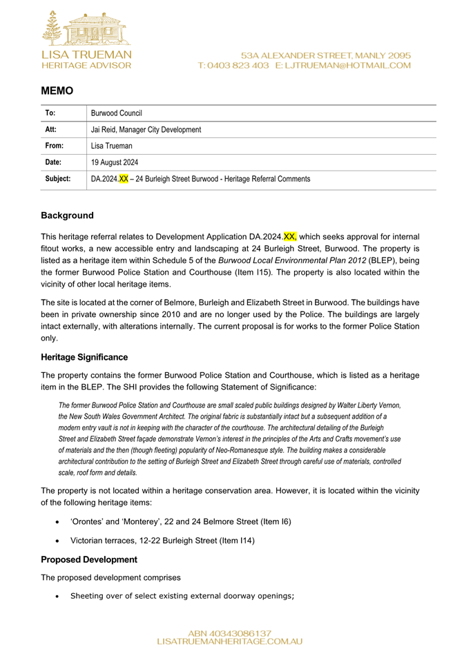
Heritage Advisor
The
application proposes building works to a local heritage item. The applicant
submitted a Heritage Impact Statement Letter, prepared by Zach Nix of - Three +
One Heritage, with the proposal. Accordingly, the application was
referred to Council’s consultant Heritage Advisor for review and comment,
who raised no objections to the proposal provided that appropriate heritage
conditions of approval be imposed in the event the application is approved.
The application therefore is
considered to satisfy Clause 5.10 of the BLEP 2012.
Please refer to Attachment
1 to view the applicant’s heritage impact statement and Attachment
2 to view Council’s heritage advisor’s referral memo.
Engineering
The application was referred to
Council’s Development Engineer for review and comment. No objections to
the proposal were raised, provided that appropriate conditions of approval be
imposed.
Tree Management
The application was referred to
Council’s Tree Management Officer for review and comment. No objections
to the proposal were raised and no conditions of approval are required.
Conclusion
The proposed development is consistent with
the relevant matters for consideration under Clause 4.15 of the EP&A Act,
as detailed above in this report. Therefore, the proposal is recommended for
approval.
Recommendation(s)
That Development Application No. DA.2024.33,
which proposes the internal fit-out and use of a heritage-listed former police
station building as a dental practice, provision of a new accessible entry,
minor external works to the building and associated landscape works, at 24 Burleigh Street, Burwood NSW 2134, be approved subject to the conditions of approval
contained in Attachment 3.
1⇩
Heritage Impact Statement
2⇩
Heritage Advisor Referral Memo
3⇩
Recommended Conditions of Approval
4⇩
Supporting Plans and Documents
Item Number DA9/24 - Attachment 1
Heritage Impact Statement
Item Number DA9/24 - Attachment
2
Heritage Advisor Referral
Memo
Item Number DA9/24 - Attachment
3
Recommended Conditions of
Approval
Item Number DA9/24 - Attachment
4
Supporting Plans and
Documents
Burwood
Local Planning Panel Meeting 17 September 2024
(Item DA10/24) Planning
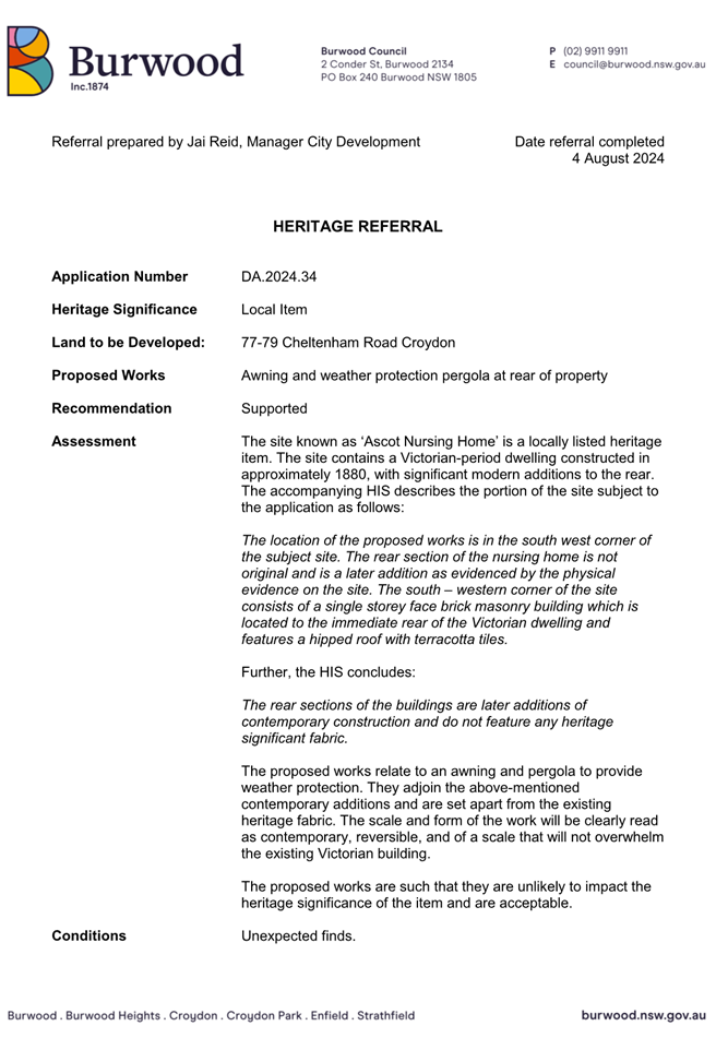
Assessment Report - 77-79 Cheltenham Road, Croydon - DA.2024.34
File No: 24/37309
Report by Executive Planner
Owner: Sister
Jeana Abejwela
Applicant: Jessica
Leslie
Location: 77-79
Cheltenham Road, Croydon
Zoning: R2
Low Density Residential
BLPP Referral Criteria
Pursuant to the Ministerial
direction dated 30 June 2020, under Section 9.1 of the Environmental
Planning and Assessment Act 1979, the DA is to be determined by the Burwood
Local Planning Panel for the following reasons:
1. The proposal seeks to undertake works to
heritage item No.141 (Ascot Nursing Home) listed within Schedule 5 of the
Burwood Local Environmental Plan 2012 (BLEP 2012).
Proposal
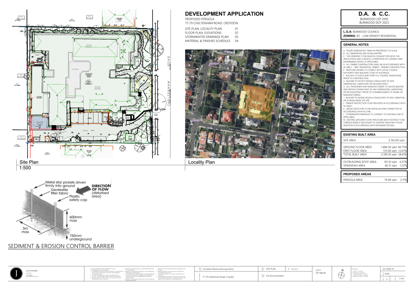
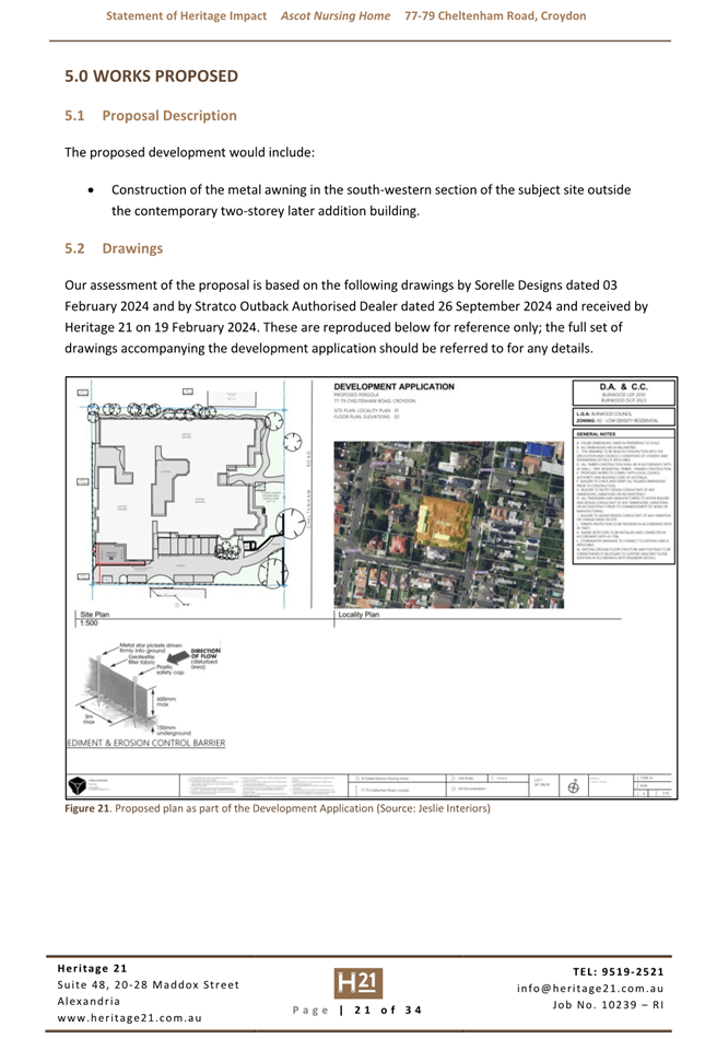
Construction of a new pergola structure to the rear yard,
attached to the existing nursing home on land at No.77-79 Cheltenham Road,
Croydon.
The specifics of the proposal are as follows:
· Pergola
to the rear yard, attached to the existing dwelling and sitting over the
existing paving.
· Pergola
Size: 16.350m x 7.450m.
· Materials:
Metal roof sheeting, steel posts and structure.
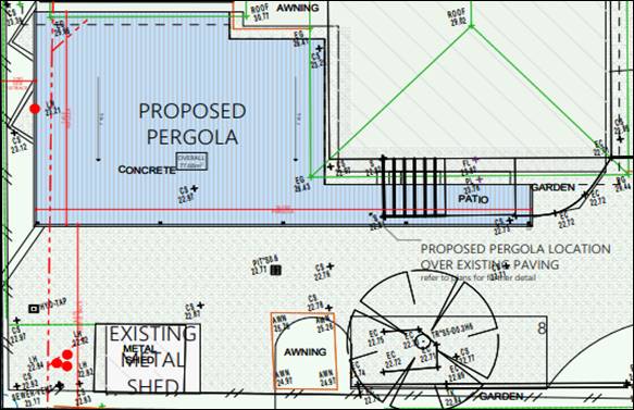
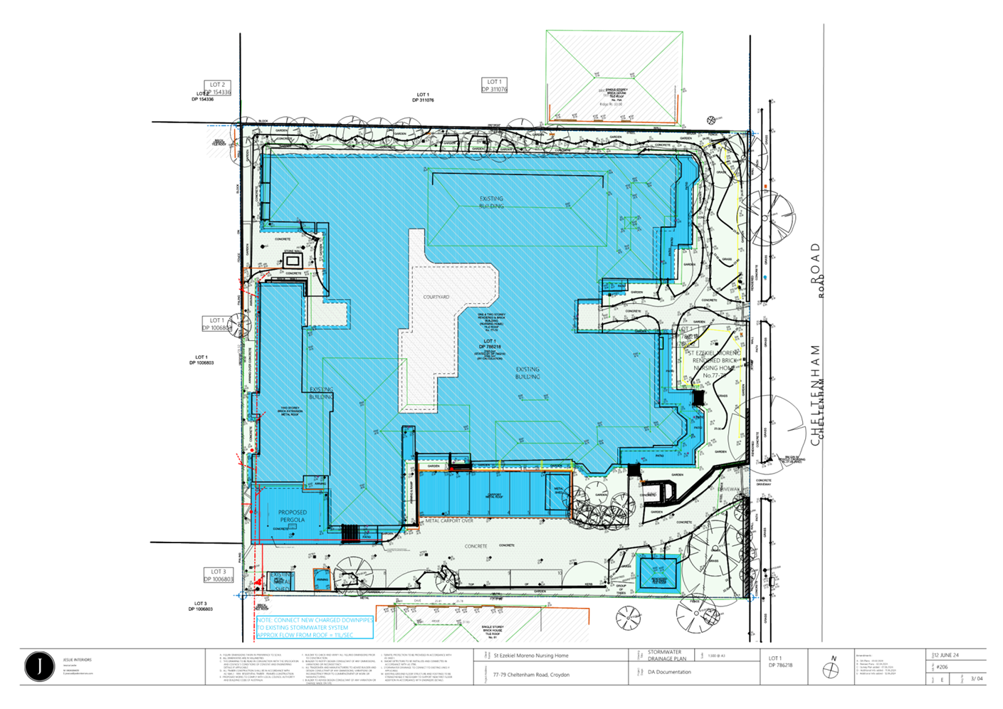
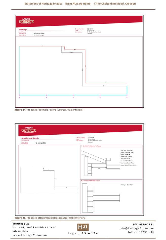
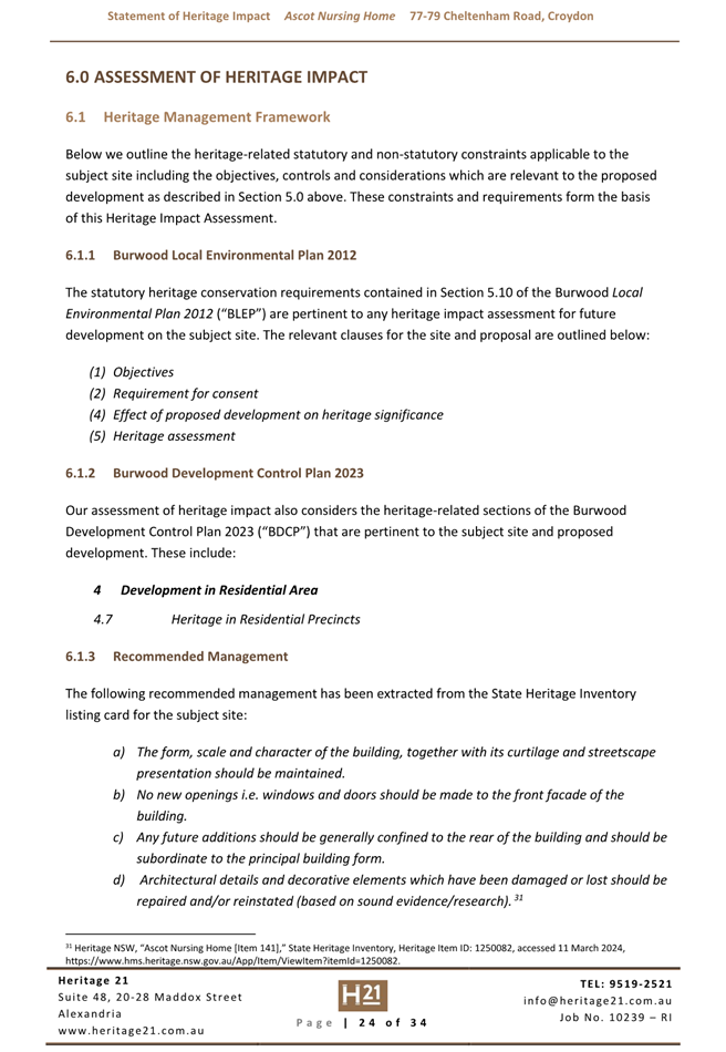
Figure 1 – Extract of applicants site plan
showing the extent of the proposed new pergola.
Source: (Architect –
Jeslie Interiors)
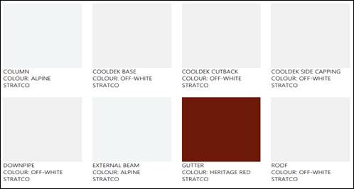
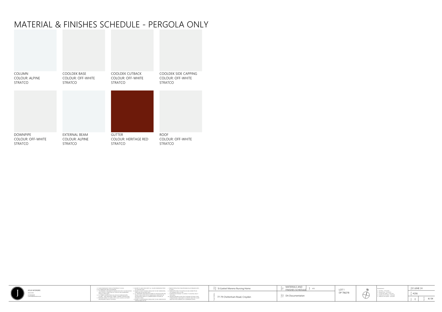
Figure 2 – Extract of applicant’s
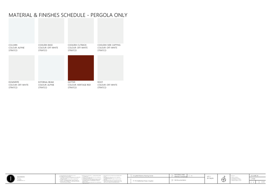
materials and finishes schedule.
Source: (Architect –
Jeslie Interiors)
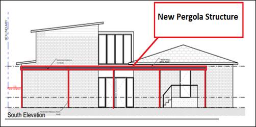
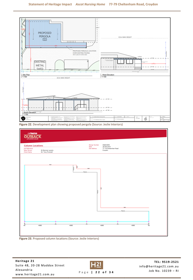
Figure 3 – Extract
of applicants submitted southern elevation showing the extent of the proposed
new pergola structure.
Source: (Architect –
Jeslie Interiors)
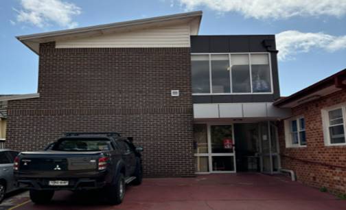
Figure 4: Location of the proposed pergola structure
at the subject site.
Source: (Site Inspection
Photograph)
It is to be noted, the proposed
pergola structure is not visible from the public domain, given the angled
driveway arrangement and dense significant vegetation at the front of the site,
adjacent to the driveway. (Refer to Figure 5 below). The pergola
structure will connect to the contemporary building at the rear of the site
which forms part of the nursing home, however is not part of the original
fabric of the heritage item on the site.
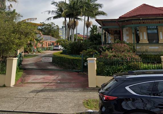
Figure 5 – Subject Site as viewed from
Cheltenham Road.
Source: (Site Inspection
Photograph)
Background
Application History
BD.2012.091 –
Alterations and additions to the existing aged care facility – approved
on 10 October 2012.
Current Application History
On 14 June 2024, the development
application (DA.2024.34) was lodged.
The application was referred to
the following internal Council departments:
- Development Engineer;
- Heritage
The application did not require
any external referrals.
In accordance with the Burwood
Community Participation Plan, the owners of surrounding properties were given
notice of the application on 25 June 2024, with the notification period for
submissions closing on 9 July 2024. In response to the public notification of
the DA, no submissions were received.
Statutory Requirements
The application is assessed under
the provisions of Section 4.15 of the Environmental Planning and Assessment
Act 1979, as amended, which include:
· State
Environmental Planning Policy (Resilience and Hazards) 2021;
· Burwood
Local Environmental Plan 2012 (BLEP 2012);
· Burwood
Development Control Plan 2013 (BDCP 2013);
· The
likely social, environmental and economic impacts of the development;
· The
suitability of the site for the development;
· The
public interest, and
· Submissions
made under the Act and Regulations.
These matters are considered in
this report.
Locality
The
site is legally described as Lot 1 within DP 786218 and is known as No.77-79
Cheltenham Road, Croydon. The subject site is a rectangular shaped rectangular
allotment with an area of 3765.1m2. The site presently accommodates
a double storey rendered brick nursing home with a tile roof, eleven (11)
existing car parking spaces and three (3) ancillary shed structures located within
the southern side setback. (Refer to Figure 10 and Figure 11
below). Vehicular access is provided to the subject site via the existing
single width driveway and crossover from Cheltenham Road.
The site has an eastern frontage
to Cheltenham Road. The topography of the site generally slopes down from
northern side boundary to the southern side boundary. The subject site is
located within the R2 Low Density Residential Zone in accordance with the BLEP
2012. (Refer to Figure 6 below). Notably, the
subject site also contains heritage item (No.141) listed within Schedule 5 of
the BLEP 2012. The site is also located directly adjacent to heritage item
(No.142) listed within Schedule 5 of the BLEP 2012. (Refer to Figure 8
below). In addition, the site is subject to the building appearance and
streetscape provisions. (refer to Figure 9 below).
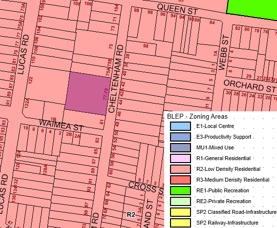
Figure 6 – Subject site located within the R2
Low Density Residential Zone.
Source: (Council MapInfo)
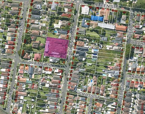
Figure 7 – Aerial Image of the Subject Site and
Surrounds.
Source: (Council MapInfo)
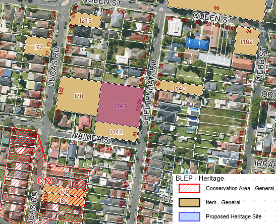
Figure 8 – Subject site contains heritage item
No.141 listed within Schedule 5 of BLEP 2012. Site also located adjacent to
heritage item No.142 listed within Schedule 5 of BLEP 2012.
Source: (Council MapInfo)
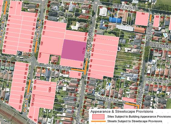
Figure 9 – Site is subject to the building
appearance and streetscape provisions.
Source: (Council MapInfo)
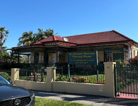
Figure 10 – Subject Site as viewed from
Cheltenham Road.
Source: (Site Inspection
Photograph)
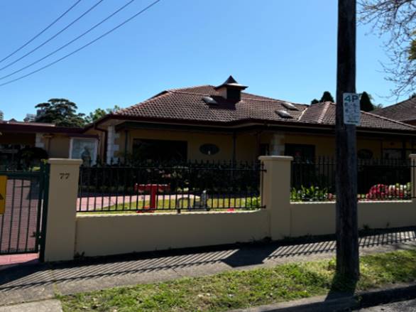
Figure 11 – Subject Site as viewed from
Cheltenham Road.
Source: (Site Inspection
Photograph)
Surrounding Development
There is general established low
density residential development all around the subject site. To the immediate
north of the subject site is No.75A Cheltenham Road, which comprises a single
storey brick dwelling house with a tile roof and detached garage located at the
rear of the site. (Refer to Figure 12 below). To the immediate south of
the site is No.81 Cheltenham Road, which comprises a single storey brick
dwelling house (heritage Item No.142, “Wyrac”) with a tile roof,
and detached outbuilding located at the rear of the site. (Refer to Figure
13 below).
On the opposite side of
Cheltenham Road is No. 1/42 Cheltenham Road, which comprises a single storey
semi-detached bring dwelling house with a tile roof. (Refer to Figure 14
below). Also opposite the subject site, across Cheltenham Road, is No.42A
Cheltenham Road, which comprises recently constructed two storey dwelling house
with a basement garage. (Refer to Figure 15 below). No.44 Cheltenham Road
is also located directly opposite the subject site and comprises a two storey
rendered brick dwelling house with a tile roof and integrated double garage at
the front of the site. (Refer to Figure 16 below). Adjoining the subject
site to the rear, is a large parcel of land known as No.122 Lucas Road which
comprises a two storey heritage item (No.72 Montrose and grounds) and a single
storey dwelling house located directly adjacent. (Refer to Figure 17 and
Figure 18 below).
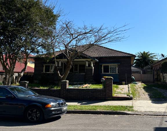
Figure 12 – No.75A Cheltenham Road, located to
the immediate north of the subject site.
Source: (Site Inspection
Photograph)
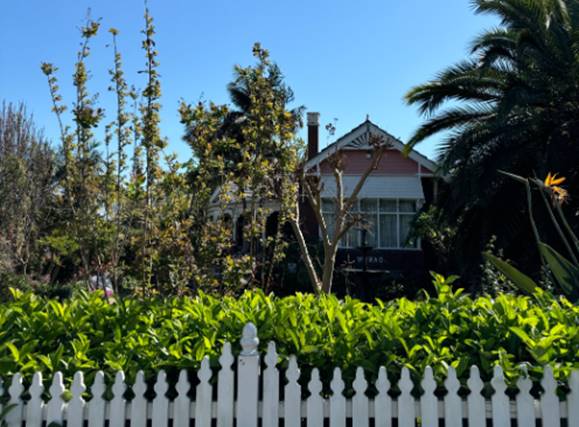
Figure 13 – No.81 Cheltenham Road, located to
the immediate south of the subject site.
Source: (Site Inspection
Photograph)
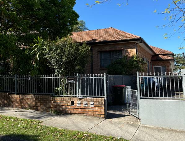
Figure 14 – No.1/42 Cheltenham Road, located
across the road to the east of the subject site.
Source: (Site Inspection
Photograph)
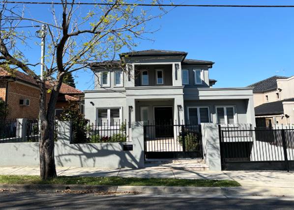
Figure 15 – No.42A Cheltenham Road, located
across the road to the east of the subject site.
Source: (Site Inspection
Photograph)
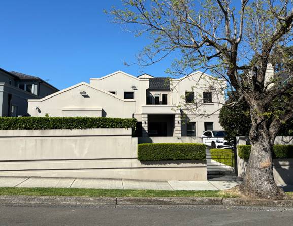
Figure 16 – No.44
Cheltenham Road, located across the road to the east of the subject site.
Source: (Site Inspection
Photograph)
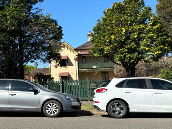
Figure 17 – No.122
Lucas Road (heritage item No.72 - 2 storey dwelling), located to the west
(rear) of the subject site.
Source: (Site Inspection
Photograph)
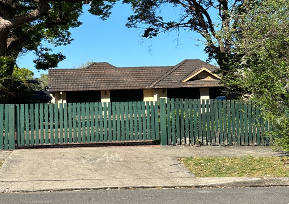
Figure 18 – No.122
Lucas Road (single storey dwelling), located to the west (rear) of the subject
site.
Source: (Site Inspection
Photograph)
Planning Assessment
State Environmental Planning Policy
(Resilience and Hazards) 2021
The provisions of SEPP
(Resilience and Hazards) 2021 are required to be considered for any development
application. Consideration must be made if the land is suitable for the
proposed development, if it is contaminated, if it is suitable for the proposed
use, and/or of the contamination is required to be remediated before the land
is used for that purpose.
The subject site has been
historically used for residential purposes as an aged care facility. As such,
it is unlikely to contain any contamination and further investigation is not
warranted in this case.
Burwood Local Environmental Plan
2012
Under Burwood LEP 2012, the
property is zoned R2 Low Density Residential, and new pergola structures are
permitted with Council’s consent.
Objectives of the R2 Low
Density Residential Zone
· To
provide for the housing needs of the community within a low density residential
environment.
· To
enable other land uses that provide facilities or services to meet the day to
day needs of residents.
The proposed development is
considered to satisfy the objectives for residential development as it will
provide for the needs of the community within a low density residential
environment.
The second objective is not of
relevance to the proposed development. The proposed satisfies the relevant
objectives for residential developments in the R2 zone.
The
Burwood Local Environmental Plan 2012 came into effect on 9 November 2012.
Burwood LEP 2012 contains a number of controls including some numerical
development standards which apply to the proposed development. A summary of the
assessment of the application against the relevant planning controls within LEP
2012 is shown in Table 1 below.
Table
1: Assessment of the proposed
development against Burwood LEP 2012
|
Burwood LEP 2012
|
Proposal
|
Compliance
|
|
4.3(2) Height
|
|
8.5m
|
Roof Ridge RL:26.00
EGL RL:23.00
Max Height of proposed Dwelling: 3m
|
Yes
|
|
4.4(2) FSR
|
|
0.55:1
|
The proposed pergola structure does not result in any
change to the existing FSR of the proposed development.
|
N/A
|
|
4.4A(2) FSR
|
|
Despite clause 4.4, the floor
space ratio for a dwelling house on land in Zone R2 Low Density Residential
with a site area of more than 500 square metres is not to exceed 0.52:1.
|
Subject site contains an aged care facility. Refer above.
|
N/A
|
|
4.6 Exceptions to Development Standards
|
|
(3) Development consent must
not be granted for development that contravenes a development standard unless
the consent authority has considered a written request from the applicant
that seeks to justify the contravention of the development standard by demonstrating
–
(a) the compliance with the
development standard is unreasonable or unnecessary in the circumstances of
the case and,
(b) that there are sufficient
environmental planning grounds to justify contravening the development
standard.
|
The proposal does not seek any variations to development
standards.
|
N/A
|
|
5.10 Heritage Conservation
|
|
(1) The objectives of this clause are as follows—
(a) to conserve the heritage significance of heritage
items and heritage conservation areas, including associated fabric, settings
and views,
(b) to conserve the heritage significance of heritage
items and heritage conservation areas, including associated fabric, setting
and views,
(c) To conserve archaeological sites,
(d) to conserve Aboriginal objects and Aboriginal places
of heritage significance
|
The subject site contains heritage item No.141
(Ascot Nursing Home) listed within Schedule 5 of the BLEP 2012. In addition,
the subject site is located directly adjacent to heritage item No.142 listed
within Schedule 5 of the BLEP 2012.
As part of the assessment of the subject DA, the
proposal was referred to Council’s Heritage Officer for comment.
In their referral response issued on 4 August
2024, no objections were raised, subject to conditions.
|
Yes
|
|
6.1 Acid Sulfate Soils
|
|
(1) The objectives of this clause is to ensure that
development does not disturb, expose or drain acid sulfate soils and cause
environmental damage.
|
The subject site is affected by Class 5 Acid Sulfate
Soils. However, there are no works proposed within 500m of adjacent Class 1,
2, 3 or 4 land that is below 5 metres Australian Height Datum and by which
the water table is likely to be lowered below 1m.
|
Yes
|
|
6.2 Flood Planning
|
|
(1) The objectives of this
clause are as follows:
(a) to minimise the flood risk
to life and property associated with the use of land,
(b) to allow development on
land that is compatible with the land’s flood hazard, taking into account
project damages as a result of climate change,
(c) to avoid significant
adverse impacts on flood behaviour and the environment.
|
The subject site is not affected by flooding.
|
N/A
|
|
Clause 6.3 Active street frontages
|
|
(1) The objectives of this clause is to promote uses that
attract pedestrian traffic along certain ground floor street frontages in
Zone B4 Mixed Use.
(2) This clause applies to land identified as
“Active street frontage” on the Active Street Frontages
Map”
(3) Development consent must not be granted to the
erection of a building, or a change of use of a building, on land to which
this clause applies unless the consent authority is satisfied that the
building will have an active street frontage after its erection or change of
use.
(4) Despite subclause (3), an active street frontage is
not required for any part of a building that is used for any of the
following—
(a) entrances and lobbies (including as part of
mixed use development),
(b) access for fire services,
(c) vehicular access.
(5) In this clause, a building
has an active street frontage if all premises on the ground floor of the
building facing the street are used for the purposes of business premises or
retail premises.
|
The subject site is not identified as “Active street
frontage” on the Active Street Frontages Map.
|
N/A
|
Burwood Development Control Plan
2013 (BDCP 2013)
The development is subject to the
provisions outlined within the table above. The provisions of BDCP have been
considered in this assessment and it is concluded that the proposal is
consistent with the aims and objectives of BDCP 2013. The proposed awning and
weather protection pergola complies with the controls contained within BDCP
2013.
Community Consultation
Internal Referrals
The application was referred to
the following internal Council departments. The below summaries their referral
comments on the latest plans:
Development Engineer - As
part of the assessment of the subject DA, the proposal was referred to
Council’s Senior Development Engineer for comment. In their referral
response issued on 24 June 2024, no objections were raised, subject to the
imposition of consent conditions.
Heritage: As part of the
assessment of the subject DA, the proposal was referred to Council’s
Heritage Officer for comment. In their referral response issued on 4 August
2024, the following was advised:
“The proposed works
relate to an awning and pergola to provide weather protection. They adjoin the
above-mentioned contemporary additions and are set apart from the existing
heritage fabric. The scale and form of the work will be clearly read as contemporary,
reversible, and of a scale that will not overwhelm the existing Victorian
building”.
“The proposed works are
such that they are unlikely to impact the heritage significance of the item and
are acceptable”.
As such, no objections were
raised by Council’s Heritage Officer, subject to conditions.
External Referrals
The application did not require
any external referrals.
Neighbour Notification
In accordance with Burwood
Community Participation plan, the owners of surrounding properties were given
notice of the application on 25 June 2024, with the notification period for
submissions closing on 9 July 2024. In response, no submissions were received.
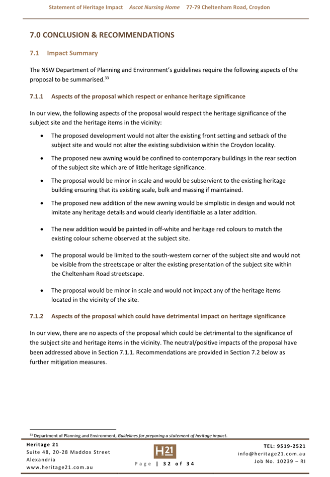
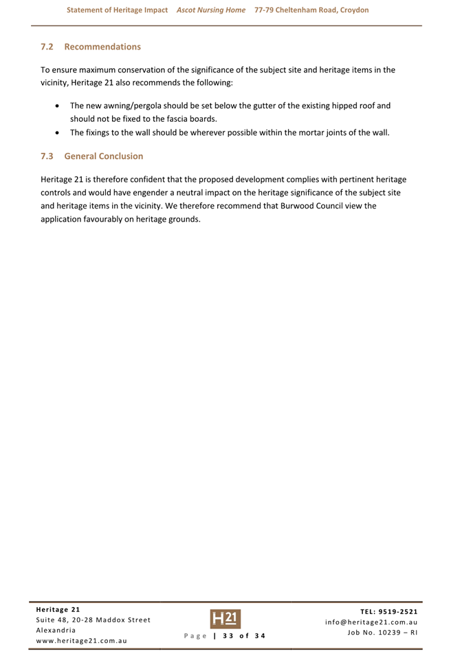
Conclusion
After consideration of the
development against section 4.15 of the Environmental Planning and
Assessment Act 1979 and the relevant statutory and policy provisions, the
proposal is satisfactory for the site and in the public interest. Therefore, it
is recommended that the application be approved, subject to conditions.
Recommendation(s)
That
Development Application (DA.2024.34) for the construction of a new pergola
structure to the rear yard, attached to the existing dwelling on land at No.77-79
Cheltenham Road, Croydon, be approved, subject to the conditions provided
within Attachment 1 of this report.
1⇩
Architectural Plans - 77-79 Cheltenham Road, Croydon -
DA.2024.34
2⇩
Architectural Plans - 77-79 Cheltenham Road - DA.2024.34
3⇩
Heritage Impact Statement - 77-79 Cheltenham Road -
DA.2024.34
4⇩
Heritage Referral - 77-79 Cheltenham Road - DA.2024.34
Item Number DA10/24 - Attachment 1
Architectural Plans -
77-79 Cheltenham Road, Croydon - DA.2024.34


Item Number DA10/24 -
Attachment 2
Architectural Plans -
77-79 Cheltenham Road - DA.2024.34
Item Number DA10/24 -
Attachment 3
Heritage Impact Statement
- 77-79 Cheltenham Road - DA.2024.34
Item Number DA10/24 -
Attachment 4
Heritage Referral - 77-79
Cheltenham Road - DA.2024.34
Burwood
Local Planning Panel Meeting 17 September 2024
(Item GB3/24) Disclosure of
pecuniary interests by Burwood Local Planning Panel Members
File No: 24/36830
Report by Acting Manager Governance and Risk
Summary
In accordance
with Clause 4.21 of the Code of Conduct for Local Planning Panel Members,
the Pecuniary Interests and Other Matters Returns required to be lodged with
the panel chair under clause 4.17 must be tabled at the next panel meeting
after the return is lodged.
Background
Under Clause
4.17 of the Code of Conduct for Local Planning Panel Members, Panel
Members are required to make and lodge a disclosure of interest with the Panel
Chair as at 30 June 2024.
In addition, new
members are to lodge their first time disclosure within one month of
appointment and before they attend any panel meetings. Burwood Council recently
appointed several new expert members to the Panel who are submitting their
first time returns.
The following
Disclosures have been lodged:
|
Position
|
Incumbent
|
Received
|
|
Chair (new)
|
Kevin Hoffman
|
22 July 2022
|
|
Alternate Chair (new)
|
Donna Rygate
|
26 July 2024
|
|
Expert Member
|
Luke Foley
|
5 August 2024
|
|
Expert Member
|
Schandel Fortu
|
5 September 2024
|
|
Expert Member
|
Linda Kelly
|
22 July 2024
|
|
Expert Member
|
Stephen Pearse
|
6 September 2024
|
|
Expert Member
|
Deborah Sutherland
|
26 July 2024
|
|
Expert Member (new member)
|
Awais Piracha
|
22 July 2024
|
|
Expert Member (new member)
|
Ian Armstrong
|
5 September 2024
|
|
Expert Member (new member)
|
Louise Bochner
|
1 August 2024
|
|
Expert Member (new member)
|
John Brockhoff
|
4 September 2024
|
|
Expert Member (new member)
|
Judith Clark
|
22 July 2024
|
|
Expert Member (new member)
|
Brian Kirk
|
25 July 2024
|
|
Expert Member (new member)
|
Michael Leavey
|
22 July 2024
|
|
Expert Member (new member)
|
Larissa Ozog
|
30 July 2024
|
|
Expert Member (new member)
|
Annette Ruhotas
|
26 July 2024
|
|
Community Member
|
Claire Boskett
|
28 July 2024
|
|
Community Member
|
Brian James
|
27 July 2024
|
|
Community Member
|
Tom Morgan
|
22 July 2024
|
|
Community Member
|
Kristy Wellfare
|
28 July 2024
|
Recommendation(s)
That the
receipt of Disclosures of Pecuniary Interest and Other Matters Returns by the
Burwood Local Planning Panel Members as listed in this report be noted and
accepted as tabled in readiness for proactive release via the Burwood Council
website.
Attachments
There are no attachments for this report.