Ordinary Meeting
Notice is hereby given that a
meeting of the Council of Burwood will be held in the Conference Room, 2 Conder
Street, Burwood on Tuesday 24 March 2026 at 6:00 PM to consider the matters
contained in the attached Agenda.
The public gallery will be open for
those wishing to observe the meeting. In addition, an opportunity to observe
the meeting via audio visual link will also be made available.
Public Forum
A public forum will be held at
6:00 pm, prior to the commencement of the meeting, to allow members of the
public to make oral submissions about an item on the Agenda for the meeting.
The opportunity will also be provided to speak via audio visual link.
Anyone wishing to address Council
during the public forum will need to register by 2:00 pm on the day of the
meeting. A person wishing to speak must indicate the item of business on the
Agenda they wish to speak on and whether they wish to speak ‘for’
or ‘against’ the item. Registrations to speak can be lodged on Council’s
website.
The Council Meeting will commence
immediately after the conclusion of the Public Forum.
Tommaso Briscese
General Manager
Councillors
Council meeting
room
Agenda
For an Ordinary Meeting of Burwood Council to be
held in the Conference Room, Level 1, 2 Conder Street, Burwood on Tuesday
24 March 2026 immediately after the Public Forum commencing at 6.00pm.
1. Prayer
Lord,
we humbly beseech thee to vouchsafe thy blessing on this Council, direct and
prosper its deliberations for the advancement of this area and the true welfare
of its people. Amen.
2. Acknowledgement
of Country
3. Statement
of Ethical Obligations
4. Recording
of Meeting
5. Apologies
6. Declarations
of Interest
7. Declaration
of Political Donations
8. Confirmation
of Minutes
Minutes of the Council Meeting held on Tuesday, 17
February 2026, copies of which were previously circulated to all councillors be
hereby confirmed as a true and correct record.
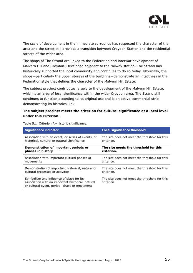
9. Mayoral
Minutes
(Item MM4/26) Infrastructure
Delivery to Support Urban Growth...................................... 5
(Item MM5/26) Keeping
Burwood Cool Competition......................................................... 6
10. Reports to Council
(Item 10/26) Burwood
North Metro Precinct – NSW Government State-Led Rezoning Proposal..................................................................................................... 7
(Item 11/26) Endorsement
of Planning Proposal for the Heritage Listing of The Strand for Submission to
DPHI for Gateway Determination.................................... 11
(Item 12/26) 2025-26
Burwood Community Satisfaction Survey............................... 186
(Item 13/26) Draft
Related Party Disclosures Policy - Endorsement for Public Exhibition 191
(Item 14/26) Draft
Statement of Business Ethics - For Adoption............................... 211
(Item 15/26) Investment
Report as at 31 January 2026 and 28 February 2026....... 219
(Item 16/26) National
General Assembly of Local Government and the Australasian Placemaking Summit
2026 - Conference Attendance.......................... 227
11. Conclusion
of the Meeting
Council Meeting 24 March 2026
Mayoral Minutes
(Item MM4/26) Infrastructure Delivery
to Support Urban Growth
File No: 26/11847
Mayoral
Minute by Cr John Faker (Mayor)
Summary
Over the next 15–20 years,
the population of the Burwood Local Government Area is expected to increase
significantly to support housing supply and employment growth, consistent with
the NSW Government’s metropolitan strategy and the designation of Burwood
as a Strategic Centre.
The strong partnership between
Council and the NSW Government has delivered a range of social and economic
outcomes, including over $110 million in transformational infrastructure
projects through the Western Sydney Infrastructure Grants Program, investment
in arts and culture through vibrancy and night-time economy initiatives, and
the delivery of the Sydney Metro, which will enable residents to travel to both
Parramatta and the Sydney CBD within approximately 10 minutes.
While these investments are
acknowledged, it is important that Council seeks clarity from the NSW
Government regarding how critical State infrastructure and services will be
planned, delivered and funded to support future growth. As population increases
within the Burwood Local Government Area, the provision of infrastructure such
as schools, health services, transport, and emergency services will be required
to support the community. It is also important that planning frameworks
supporting future growth include clear mechanisms to facilitate the delivery
and provision of additional open space for the community.
Operational Plan Objective
C.3 An
urban environment that maintains and enhances our sense of identity and place.
C.3.1 Facilitate
well designed, high quality and sustainable land use and development that is
appropriately scaled to complement its surroundings.
C.4 Sustainable,
integrated transport, infrastructure and networks to support population growth
and improve liveability and productivity.
C.4.2
Plan for a city that is safe, accessible and easy to
get to and move around in
I therefore move that:
That the
Mayor write to the NSW Minister for Planning and Public Spaces and the Local
Member for Strathfield seeking confirmation that any urban transformation
within the Burwood Local Government Area, and associated population growth,
will be supported by the timely planning, delivery and funding of adequate
state infrastructure, including schools, health services, transport, and
emergency services, and that planning frameworks include clear mechanisms to
facilitate the provision of additional open space to support the growing
community.
There are no attachments for this report.
Council Meeting 24 March 2026
(Item MM5/26) Keeping Burwood Cool Competition
File No: 26/4976
Mayoral
Minute by Cr John Faker (Mayor)
Summary
Burwood has recently been
recognised as Australia’s coolest neighbourhood, but being cool is not
only about culture, food and vibrancy. It is also about creating a greener,
healthier and more comfortable place to live.
For years, Council has made a
strong and sustained investment in greening Burwood’s neighbourhoods,
including extensive tree planting across streets, parks and public spaces, with
almost $1 million invested. Initiatives such as the Mayoral Street Tree
Planting Program, now in its sixth year, have played a key role in
strengthening urban canopy and improving street amenity across the LGA, with
over 1,600 trees planted to date.
There is an opportunity to build
on this momentum through a new community initiative, the “Keeping Burwood
Cool Competition”, celebrating the residents who are helping to green and
cool Burwood through their planting efforts.
Across the community residents are
already making meaningful contributions by caring for their gardens, balconies and
other small green spaces around their homes. These everyday efforts
collectively shape the character of our streets, enhance neighbourhood amenity,
and support a healthier and more liveable environment for all.
Greening also plays an important
role in supporting wellbeing and improving urban comfort. When multiplied
across streets and communities, these small contributions help create cooler,
greener and more pleasant places for everyone to enjoy.
This competition could recognise
gardens, verges, balconies and other green spaces that contribute to cooling
and beautifying the local environment. A small prize could be awarded to the
winner or winners across categories, to recognise effort and contribution,
based on people’s votes and a selection overseen by Council staff.
This initiative aligns with
Council’s continued commitment to urban greening, improving neighbourhood
amenity, supporting wellbeing and strengthening community pride of place, while
reinforcing Burwood’s identity as a cool, vibrant and liveable
neighbourhood.
Operational Plan Objective
C.2.3 Provide opportunities for
people to participate in activities and events that celebrate our diverse
community, history and culture
I therefore move that:
1. The General Manager investigate the
establishment of an annual Keeping Burwood Cool Competition, commencing in
2026.
2. The General Manager investigate the
development of a policy to enable planting on verges, to further encourage
community participation in greening and cooling Burwood’s neighbourhoods.
There are no attachments for this report.
Council Meeting 24 March 2026
Reports to Council
(Item 10/26) Burwood North Metro
Precinct – NSW Government State-Led Rezoning Proposal
File No: 26/12476
Report by Director City Strategy
Summary
The NSW Government has placed an
updated Burwood North Metro Precinct Masterplan on public
exhibition as part of a State-led rezoning process for land surrounding the
future Burwood North Metro Station.
The proposal is currently on
exhibition until 10 April 2026, with submissions required to be made directly
to the NSW Department of Planning, Housing and Infrastructure (DPHI) by both
community members and councils.
The proposal includes an increase
in development density and associated population growth, which has implications
for the provision of physical and social infrastructure.
This report seeks Council’s
endorsement for Council to prepare and submit a technical submission to DPHI on
the exhibited Masterplan, including addressing the delivery and funding of the
physical and social infrastructure required to support increased density within
the precinct, as well as consideration of infrastructure delivery
responsibilities and development contributions and funding mechanisms.
Operational Plan Objective
A.63 Research
plans and opportunities for the creation of public open spaces as part of the
planning of the Burwood North Precinct.
A.76 Undertake
initiatives that support new economic growth in the Burwood North Precinct and
Burwood Town Centre.
C. 3 An
urban environment that maintains and enhances our sense of identity and
place.
C.3.1 Facilitate
well designed, high quality and sustainable land use and development that is
appropriately scaled to complement its surroundings.
C.4 Sustainable,
integrated transport, infrastructure and networks to support population growth
and improve liveability and productivity.
C.4.2 Plan
for a city that is safe, accessible and easy to get to and move around in
Background
The NSW Government has placed the
updated Burwood North Metro Precinct Masterplan on public
exhibition as part of a State-led rezoning process for land surrounding the
future Burwood North Metro Station. The proposal is being progressed by the NSW Department of Planning, Housing and Infrastructure
(DPHI) through the State Significant Rezoning Pathway, following the
NSW Government’s 2025 decision to assume responsibility for rezoning the
precinct and build upon master planning work previously undertaken by Burwood
Council and Canada Bay Council.
The rezoning proposal seeks to
amend the planning controls within the Burwood Local Environmental Plan 2012
(BLEP 2012) and the Canada Bay Local Environmental Plan 2013 (CBLEP 2013).
These amendments are intended to facilitate increased housing supply, employment
opportunities and supporting infrastructure within a transit-oriented precinct
aligned with the delivery of the Sydney Metro West project, which is scheduled
for completion in 2032.
The precinct comprises
approximately 113 hectares of land within an 800-metre walking catchment of the
future metro station, located at the intersection of Burwood Road and
Parramatta Road. It spans land within both the Burwood and Canada Bay local
government areas and is identified as a key urban renewal area within broader
strategic planning frameworks, including the Parramatta Road Urban
Transformation Strategy.
Key elements of the proposal
include capacity for approximately 18,300 new dwellings, including a
requirement for 5–10 per cent affordable housing, and approximately 3,900
additional jobs. The proposal also includes the provision of more than 20 pocket
parks and greenways, enhanced public domain areas, and improved active
transport connections, including walking and cycling links. Building heights
are proposed to range from approximately 8 to 42 storeys (28 to 140 metres),
reflecting a transition to a high-density, mixed-use environment centred on the
future metro station.
The proposal introduces changes
to land use zoning, including the application of MU1 Mixed Use, R4 High Density
Residential and SP2 Infrastructure zones to support a mix of residential,
commercial, employment and community use. Amendments to floor space ratio and
building height controls are also proposed to facilitate increased development
capacity, supported by urban design analysis and feasibility testing.
The proposal also includes the
identification of key sites intended to deliver public benefits, such as open
space, through-site links, public domain improvements, and road infrastructure.
These sites may be eligible for incentive-based planning controls where
identified infrastructure outcomes are delivered. Additional provisions relate
to active street frontages, design excellence, and the preparation of a
precinct-specific Design Guide to support built form, public domain, and
amenity outcomes.
The proposal is currently on
public exhibition until 10 April 2026, with submissions required to be made
directly to DPHI. Submissions received during the exhibition period will inform
the finalisation of the rezoning proposal, with an outcome anticipated in 2026.
Proposal
This report seeks endorsement for
Council to undertake a review of the NSW Government’s publicly exhibited
Burwood North Metro Precinct Masterplan and supporting documentation, and to
prepare and submit a technical submission on planning and urban design matters
to the NSW Department of Planning, Housing and Infrastructure (DPHI).
As part of this submission,
specific consideration is to be given to infrastructure-related matters,
including infrastructure provision, delivery responsibilities, and funding
mechanisms. Noting that the scale of proposed development and associated population
growth has implications for the provision of physical and social
infrastructure, including transport infrastructure, open space, schools, health
services, community facilities, emergency services, and affordable housing.
Development Contributions
Framework
Infrastructure funding and
delivery for the precinct is proposed to occur through a combination of local
and State mechanisms. Local infrastructure is typically funded through
development contributions plans, while State infrastructure may be supported through
mechanisms such as the Housing and Productivity Contribution and capital
funding programs. DPHI has indicated that further work will be undertaken in
collaboration with councils to align infrastructure delivery with the timing
and scale of development.
Local infrastructure
contributions, also referred to as developer contributions, are levied by
councils under the Environmental Planning and Assessment Act 1979 to fund
infrastructure required to support development. This includes infrastructure
such as parks, community facilities, local roads, footpaths, stormwater
drainage, and traffic management works.
Contributions are generally
collected through Section 7.11 contributions, which are based on the
relationship between development and infrastructure demand, and Section 7.12
levies, which are applied as a percentage of development cost.
Council currently delivers local
infrastructure through development contributions plans, including a 4% levy
within the Burwood Town Centre, supported by Council’s Voluntary Planning
Agreement (VPA) Policy. Any submission should include a request for at least
the same application or adaptation of similar infrastructure funding mechanisms
within the Burwood North Metro Precinct to support infrastructure delivery
associated with future growth as 7.11 contributions are capped at a maximum of
$20,000 per dwelling and lower percentages under 7.12 contributions will
possibly lead to a funding shortfall impacting councils’ financial
sustainability.
Open Space Provision and
Ongoing Maintenance
The exhibited masterplan
identifies the delivery of new and enhanced open space within the precinct,
including parks, greenways, and public domain improvements. The provision of
this open space appears to be facilitated through incentive-based planning mechanisms,
including key site provisions, which may enable the delivery and dedication of
land for public use. Consideration should be given to ensuring that any land
delivered for public open space is provided to Council at no cost as part of
the development process.
Given the scale of proposed
growth and the associated increase in public infrastructure assets, there are
ongoing implications for Council in relation to maintenance, renewal, and
operational costs. Consideration should also be given to the availability of
State funding mechanisms, including grants or other funding programs, to
support the long-term maintenance and management of new infrastructure
delivered as part of the precinct.
Affordable Housing
The proposal incorporates an
affordable housing requirement of 5–10 per cent of new residential
development, to be delivered either as dwellings or as equivalent contributions
and managed by a registered community housing provider. Council should also
advocate for additional planning mechanisms to increase social infrastructure
such as affordable housing through the activation of existing provisions under
relevant State Environmental Planning Policies for infill affordable housing,
or the introduction of a similar mechanism through amendments to
Council’s Local Environmental Plan to achieve the same outcomes in
support of the delivery of affordable housing and associated community
infrastructure within the precinct.
Consultation
The NSW Government has placed an
updated Burwood North Metro Precinct Masterplan is currently on public
exhibition until 10 April 2026 as part of a State-led rezoning process for land
surrounding the future Burwood North Metro Station.
Any community or Council
submissions is required to be made directly to the NSW Department of Planning,
Housing and Infrastructure (DPHI) by both community members and councils.
Planning or Policy Implications
The publicly exhibited The NSW
Government updated Burwood North Metro Precinct Masterplan looks to made
amendments to Burwood Local Environment Plan 2012 to increase housing and jobs
in the Burwood North and Concord area. This will result in zoning, height, FSR
and other planning control changes along with a variation to the urban form of
the area. Any change to density will have implication on infrastructure for the
LGA and a need to fund, implement and maintain new assets.
Financial Implications
Any change
to density in the Burwood North Precinct will have financial implication on
infrastructure for the LGA and a need to fund, implement and maintain new
assets.
Conclusion
The NSW Government has exhibited
an updated masterplan for the Burwood North Metro Precinct as part of a
State-led rezoning process around the future metro station.
Public submissions are open until
10 April 2026 and are to be made directly to the NSW Department of Planning,
Housing and Infrastructure.
The proposal introduces increased
development capacity and population growth, with associated requirements for
supporting physical and social infrastructure.
This report seeks Council’s
endorsement to prepare and submit a technical response to the exhibited
masterplan, including consideration of infrastructure provision, delivery
responsibilities, and funding arrangements.
Recommendation(s)
1. Council notes that the NSW
Government has placed the Burwood North Metro Precinct Masterplan on public
exhibition as part of the State-led rezoning process, with submissions open
until 10 April 2026 and to be made directly to the NSW Department of Planning,
Housing and Infrastructure.
2. The General Manager prepare
and submit a technical submission to the NSW Department of Planning, Housing
and Infrastructure which also addresses the need for infrastructure provision
to support the population growth, appropriate funding mechanisms for required
infrastructure and the need to increase provision of social infrastructure
within the proposed rezoning as outlined in this report.
Attachments
There are no attachments for this report.
Council Meeting 24 March 2026
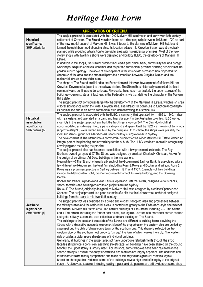
(Item 11/26) Endorsement of Planning Proposal for the Heritage Listing of
The Strand for Submission to DPHI for Gateway Determination
File No: 26/11359
Report by Director City Strategy
Summary
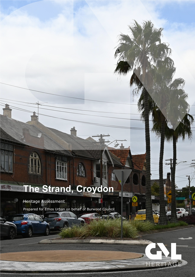
Council has
prepared a Planning Proposal (Attachment 1) to amend Schedule 5 of the Burwood
Local Environmental Plan (BLEP) 2012 by adding a group heritage listing for The
Strand, Croydon. The Planning Proposal applies to the properties located at 1–50
The Strand, Croydon.
The Planning
Proposal responds to Council’s resolution at its Extraordinary Meeting of
29 January 2025, following the NSW Government’s Transport Oriented
Development (TOD) Program for Croydon (gazetted by DPHI on 6 February 2026),
where it resolved to further protect the buildings and shops within the
commercial areas of the existing Heritage Conservation Area of The Strand,
Croydon by pursuing their listing as a group heritage item.
The Planning
Proposal is supported by a heritage assessment (Attachment 2) prepared by an
independent heritage consultant, GML Heritage. The assessment demonstrates that
the subject sites meet the threshold for local group heritage listing,
satisfying multiple criteria established by the NSW Heritage Office.
In
accordance with Ministerial Directions under the Environmental Planning and
Assessment Act 1979, advice was sought from the Burwood Local Planning Panel
(BLPP) on the Planning Proposal. The BLPP has subsequently endorsed the
Planning Proposal for progression to Gateway Determination to amend the Burwood
Local Environmental Plan 2012.
Operational Plan Objective
C.3 An
urban environment that maintains and enhances our sense of identity and place.
C.3.1 Facilitate well
designed, high quality and sustainable land use and development that is
appropriately scaled to complement its surroundings.
C3.2 Protect
our unique built heritage and maintain or enhance local character.
C.1.1 Support and
deliver initiatives that encourage high-quality design, sustainable development
and enhanced urban amenity.
C.10 A
well informed community active in civic life, local planning and decision
making
P.38 Deliver
attractive, healthy streetscapes and centres that are inviting and foster
community pride
Background
Council
Resolution and Croydon Masterplan Response
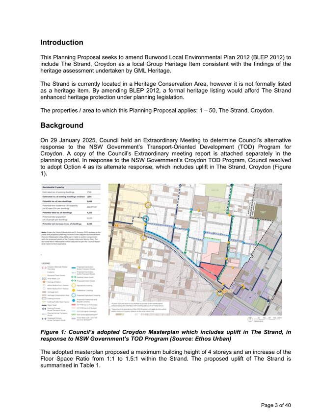
On 29
January 2025, Council held an Extraordinary Meeting to determine its
alternative response to the NSW Government’s Transport-Oriented
Development (TOD) Program for Croydon. A copy of the Council report can be
accessed here.
In response
to the NSW Government’s Croydon TOD Program, Council resolved to adopt
Option 4 as its alternate response, which includes uplift in The Strand,
Croydon.
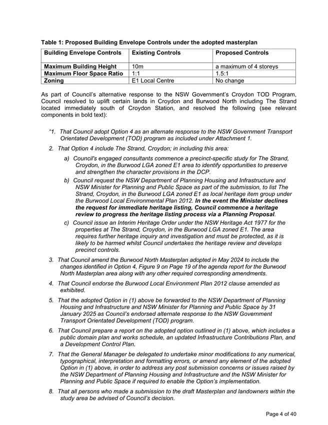
The adopted
masterplan proposed a maximum building height of four storeys and an increase
in the Floor Space Ratio (FSR) from 1:1 to 1.5:1 within The Strand.
Council’s
resolution includes the following as it relates to The Strand, Croydon:
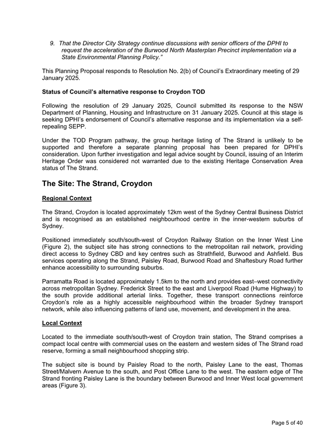
“2.
That Option 4 include The Strand, Croydon; in including this area:
a) Council's engaged consultants commence a
precinct-specific study for The Strand, Croydon, in the Burwood LGA zoned E1
area to identify opportunities to preserve and strengthen the character
provisions in the DCP.
b) Council request the NSW Department of
Planning Housing and Infrastructure and NSW Minister for Planning and Public
Spaces as part of the submission, to list The Strand, Croydon, in the Burwood
LGA zoned E1 as local heritage item group under the Burwood Local Environmental
Plan 2012. In the event the Minister declines the request for immediate
heritage listing, Council commence a heritage review to progress the heritage
listing process via a Planning Proposal.
c) Council issue an Interim Heritage Order under
the NSW Heritage Act 1977 for the properties at The Strand, Croydon, in the
Burwood LGA zoned E1. The area requires further heritage inquiry and
investigation and must be protected, as it is likely to be harmed whilst
Council undertakes the heritage review and develops precinct controls.”
The full
minutes of Council’s Extraordinary meeting of 29 January 2025 can be
accessed here.
NSW
Government Transport-Oriented Development Program
Council’s
endorsed alternate Croydon Masterplan was submitted to the Department of
Planning, Housing and Infrastructure (DPHI) on 31 January 2025.
On 6
February 2026, the NSW Government gazetted and implemented the
Transport-Oriented Development (TOD) Program for Croydon within the Burwood
Local Government Area.
The scheme
was implemented through the gazettal of State Environmental Planning Policy
(Amendment – Croydon North Masterplan Precinct) 2026. This is a
self-repealing planning instrument and has the effect of amending the Burwood
Local Environmental Plan 2012 to introduce changes to zoning, floor space
ratios and maximum building heights across parts of Croydon.
A copy of
the amending SEPP is available at the following link: Notice of Gazettal , with updated precinct
maps available on the NSW Governments Eplanning Spatial Viewing Platform
Heritage
Listing Request for The Strand
As
anticipated, although Council requested the group heritage listing of The
Strand through the TOD Program pathway, the amending SEPP did not include this
listing. Accordingly, a separate Planning Proposal has been prepared for
DPHI’s consideration.
Further
investigation and legal advice obtained by Council confirmed that the issuing
of an Interim Heritage Order was not available due to the existing Heritage
Conservation Area status of The Strand.
Early
Engagement and Community Feedback
Early
engagement on the proposed heritage listing of The Strand commenced on 18
August 2025 and concluded on 22 September 2025. During this period, a total of
23 submissions were received. Of these:
· 19
submissions were received through the Participate Burwood online platform; and
· 4
submissions were received via direct email correspondence to Council, including
submissions from the Burwood & District Historical Society and the National
Trust of Australia (NSW).
None of the
submissions received objected to the proposed group heritage listing of The
Strand.
Burwood
Local Planning Panel Advice
In
accordance with Ministerial Directions under the Environmental Planning and
Assessment Act 1979, advice on the Planning Proposal was sought from the
Burwood Local Planning Panel (BLPP) on 16 October 2025.
The BLPP
subsequently endorsed the Planning Proposal for the heritage listing of The
Strand properties. A copy of the BLPP resolution is available in Attachment 5.
Next
Steps
The matter
is now before Council for endorsement of the Planning Proposal for progression
to Gateway Determination to amend the Burwood Local Environmental Plan 2012.
Proposal
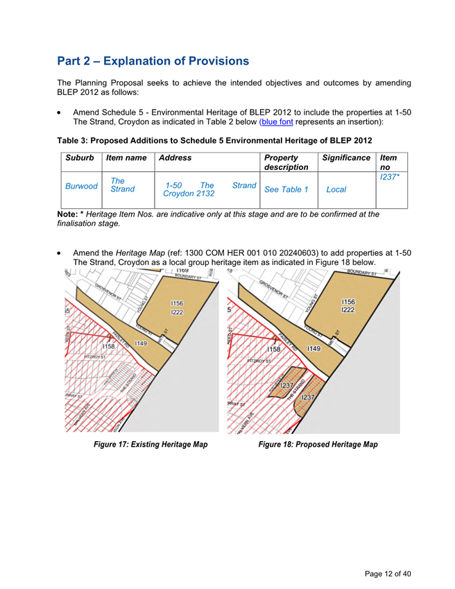
The Planning Proposal seeks to
amend BLEP 2012 to include the properties at 1-50 The Strand, Croydon as a
local group heritage item through their listing in Schedule 5 - Environmental
Heritage and identification on the Heritage Map.
The Planning Proposal seeks to
achieve the intended objectives and outcomes by amending Burwood LEP 2012 as
follows:
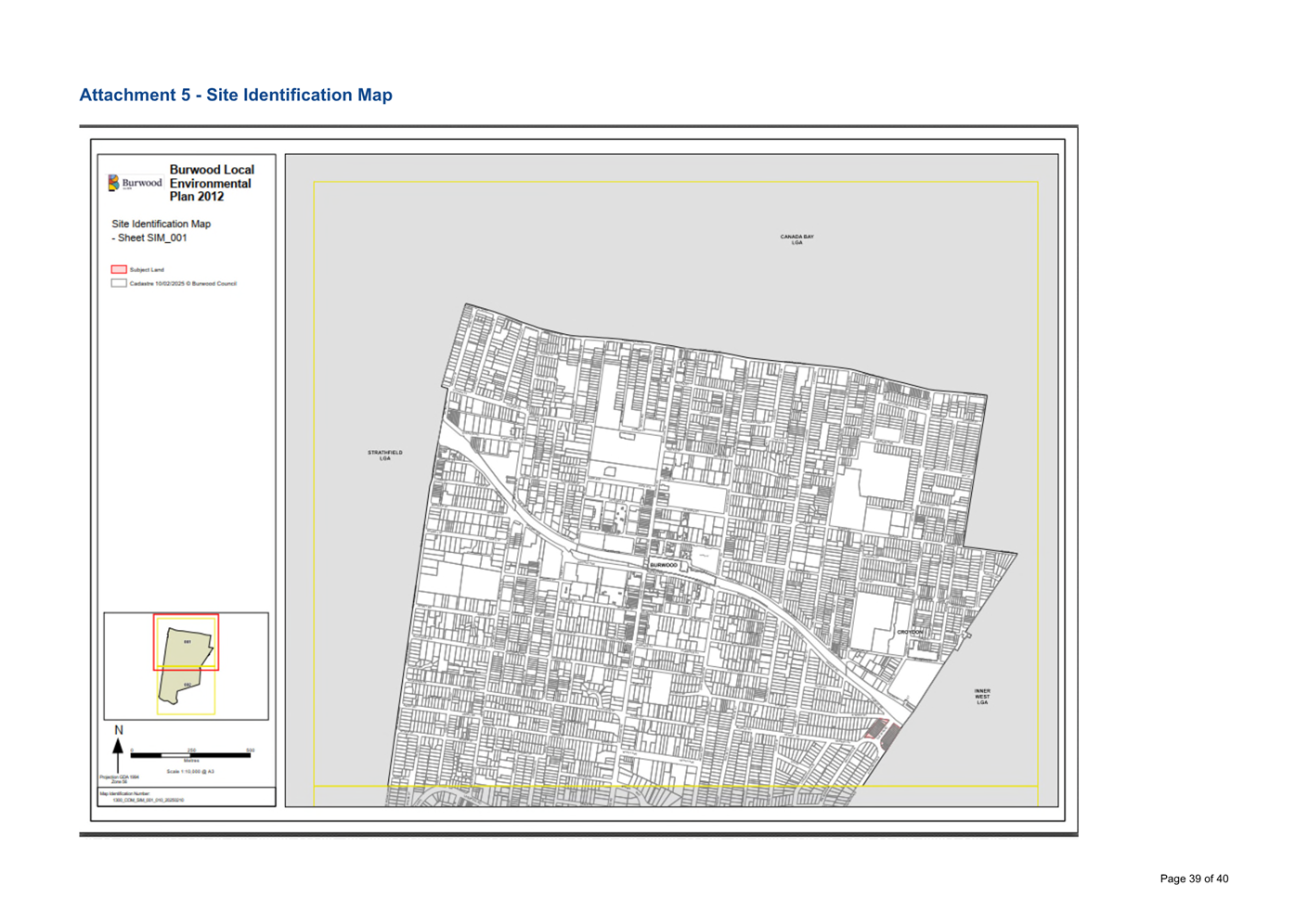
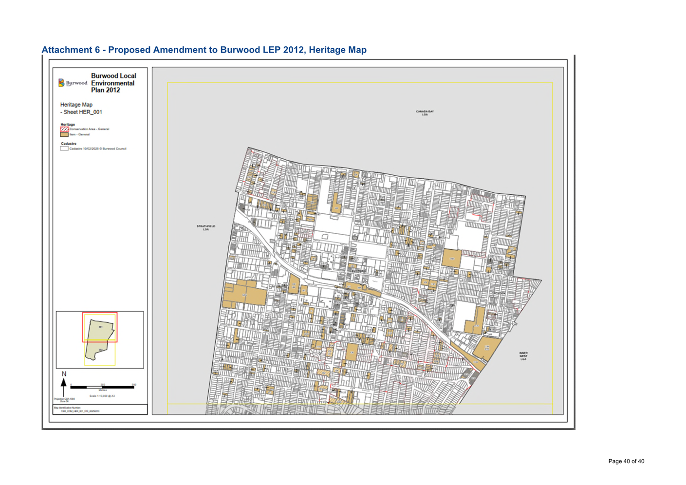
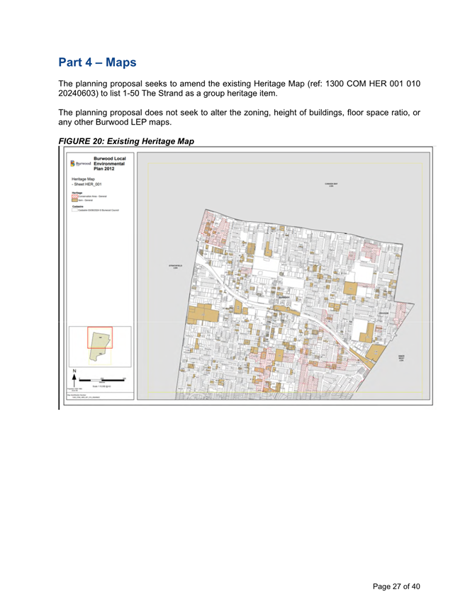
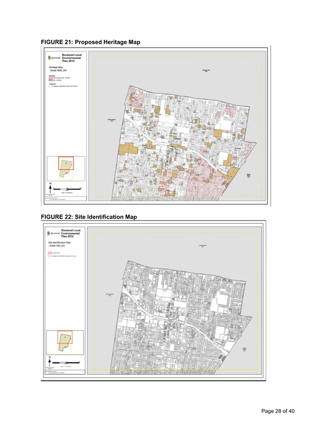
· Amend the existing Heritage Map (ref:
1300 COM HER 001 010 20240603) (Figure 14) to add properties at 1-50 The
Strand, Croydon as a local group heritage item as indicated in Figure 15 below.
· Amend Schedule 5 - Environmental Heritage to
include the properties at 1-50 The Strand, Croydon as indicated in Table 3
below (blue font represents an insertion):
Attachment
1 contains the draft Planning Proposal Report in the format required by the
Department of Planning, Housing and Industry (DPHI). This report contains
detailed information on the planning proposal as it relates to the heritage
significance of The Strand, Croydon to facilitate its group listing under
Schedule 5 of BLEP 2012.
Attachment
2 is the Heritage Assessment Report for The Strand Croydon, dated August
2025. This report provides a detailed heritage assessment of The Strand,
Croydon to support its proposed group heritage listing.
Attachment
3 contains the exhibited draft Heritage Inventory Sheet in the format
required by the Heritage NSW and contains the key summary of the assessment
completed by GML.
Site
Context
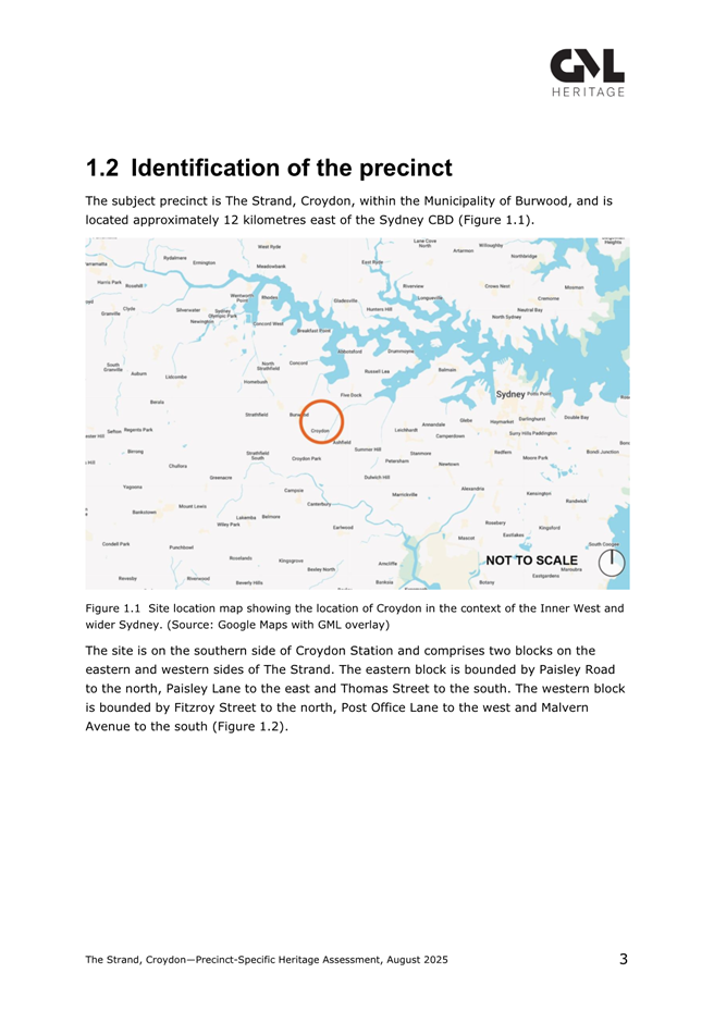
Regional
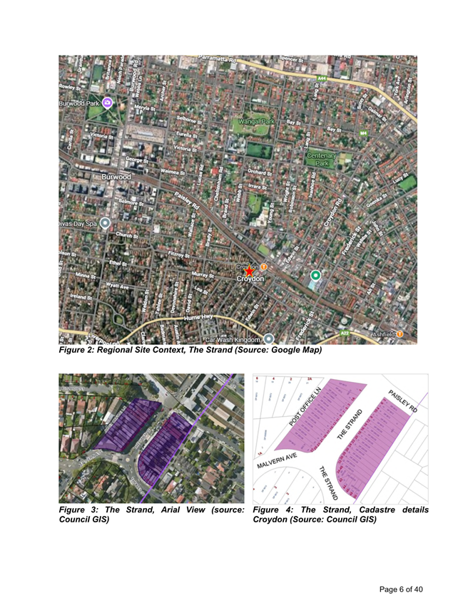
Context
The Strand,
Croydon is located approximately 12 kilometres west of the Sydney CBD and is
recognised as an established neighbourhood centre in the inner-western suburbs
of Sydney.

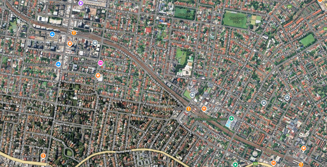
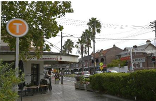
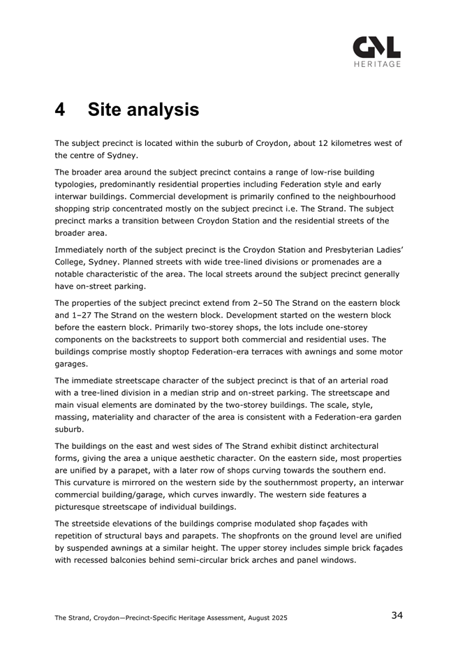
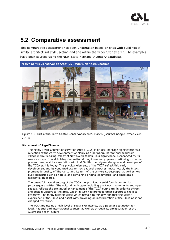
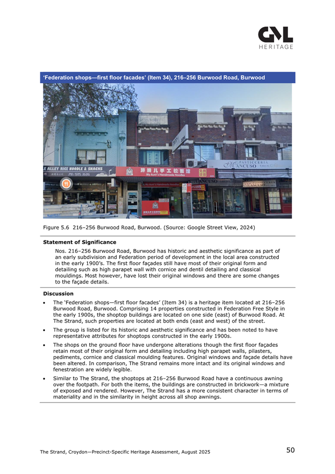
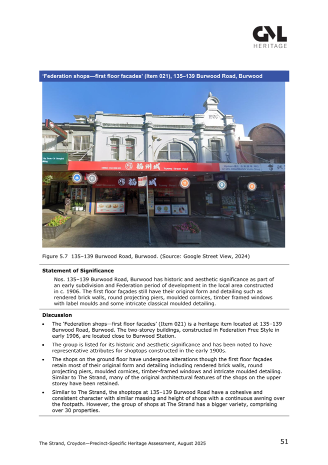
Figure
1: Site Context, The Strand, Croydon (Source: Google Map)
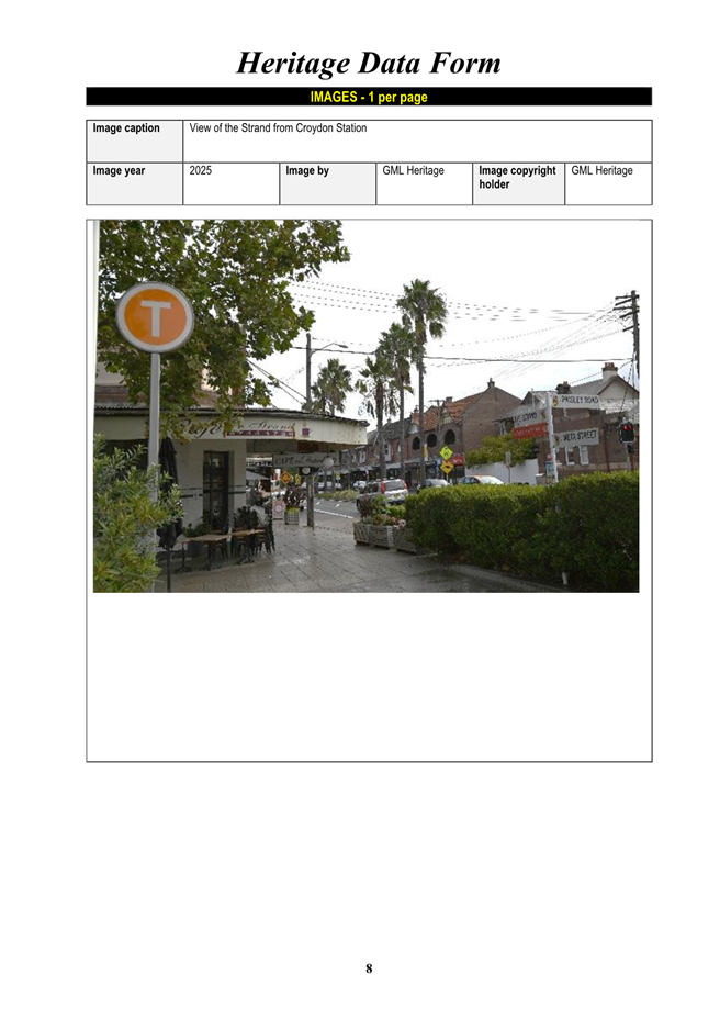
Positioned
immediately south/south-west of Croydon Railway Station on the Inner West Line
(Figure 1), the subject site has strong connections to the metropolitan rail
network, providing direct access to Sydney CBD and key centres such as
Strathfield, Burwood and Ashfield. Bus services operating along the Strand,
Paisley Road, Burwood Road and Shaftesbury Road further enhance accessibility
to surrounding suburbs.
Parramatta
Road is located approximately 1.5km to the north and provides east–west
connectivity across metropolitan Sydney. Frederick Street to the east and
Liverpool Road (Hume Highway) to the south provide additional arterial links.
Together, these transport connections reinforce Croydon’s role as a
highly accessible neighbourhood within the broader Sydney transport network,
while also influencing patterns of land use, movement, and development in the
area.
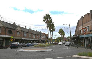
Local Context
Located to
the immediate south/south-west of Croydon train station, The Strand comprises a
compact local centre with commercial uses on the eastern and western sides of
The Strand road reserve, forming a small neighbourhood shopping strip.
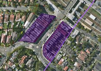
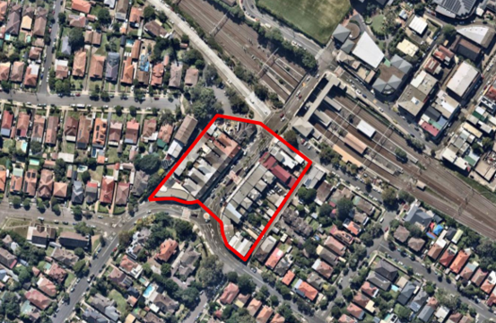
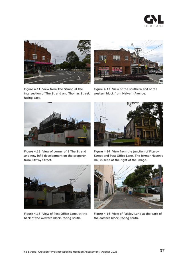
The subject site is bound by Paisley Road to the
north, Paisley Lane to the east, Thomas Street/Malvern Avenue to the south, and
Post Office Lane to the west. The eastern edge of The Strand fronting Paisley
Lane is the boundary between Burwood and Inner West local government areas
(Figure 2).
|
|
|
|
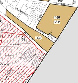
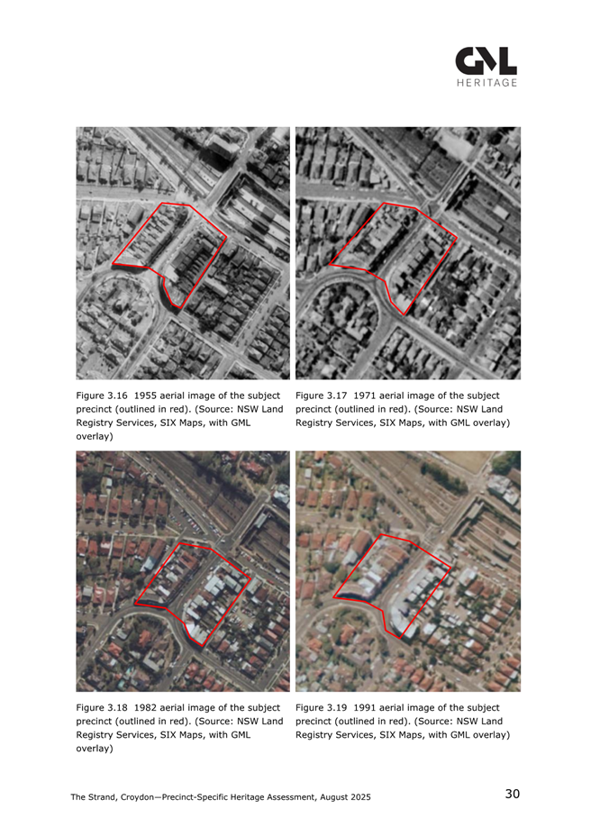
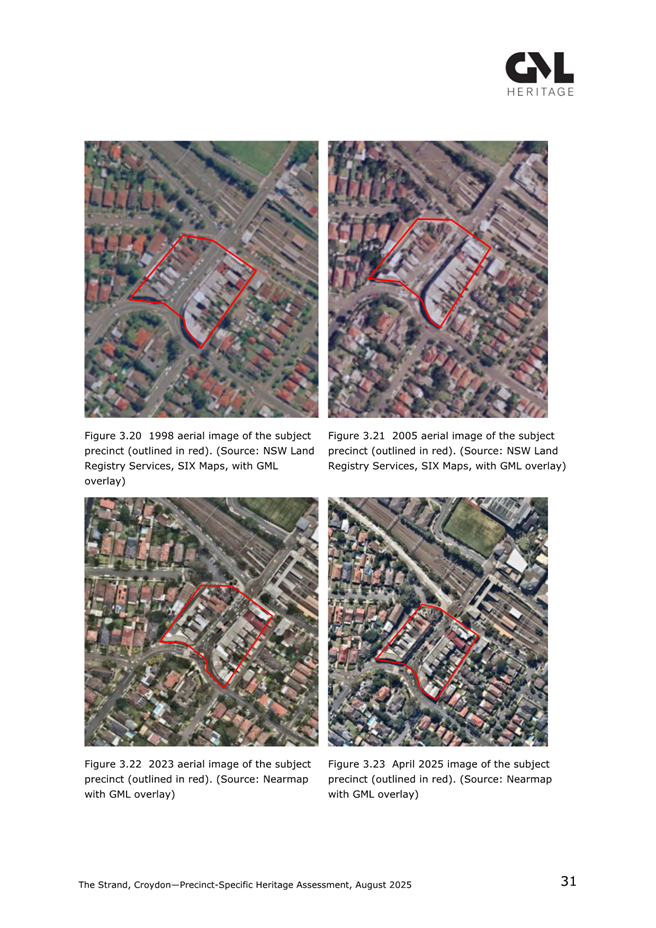
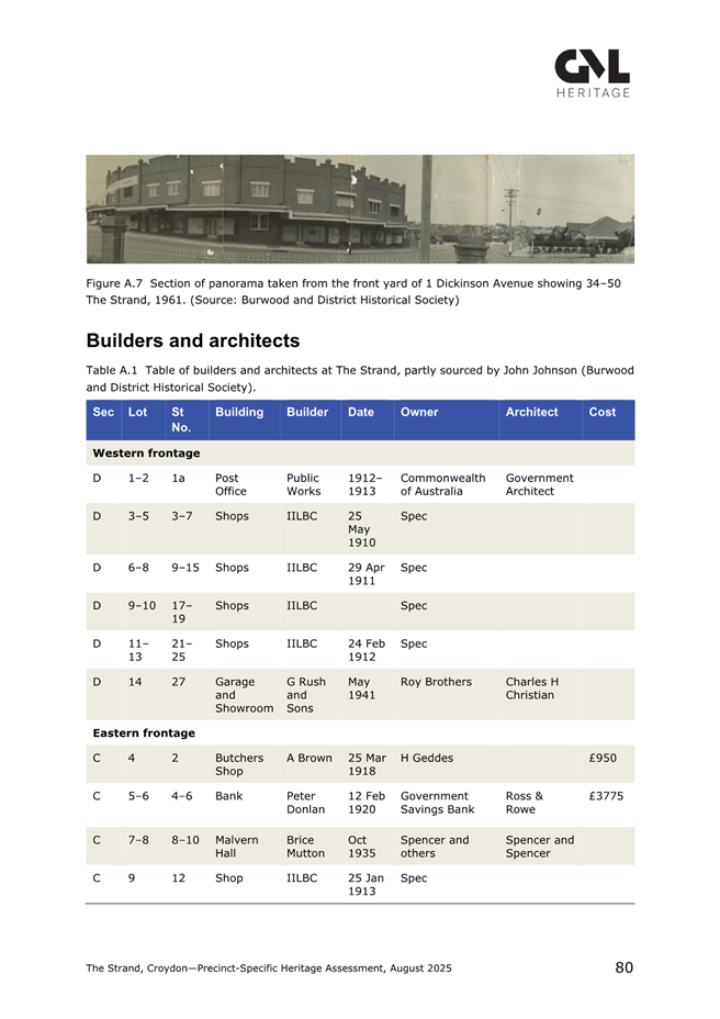
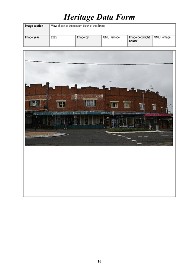
Figure 2: The Strand, Aerial View (source: Council GIS)
|
Figure 3: The Strand,
Cadastre details Croydon (Source: Council GIS)
|
Statutory Planning Context
|
|
|
|
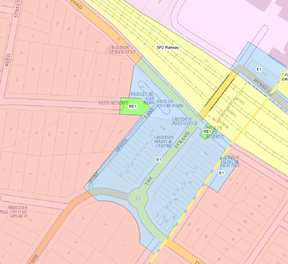
Figure 4: Existing
Zoning
(Source: NSW Eplanning
Spatial Viewer)
|
Figure 5: Existing
Maximum FSR
(Source: NSW Eplanning
Spatial Viewer)
|
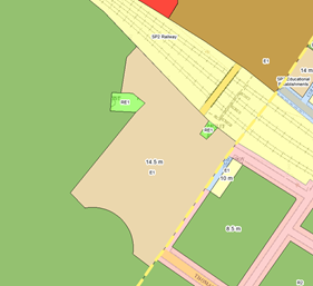
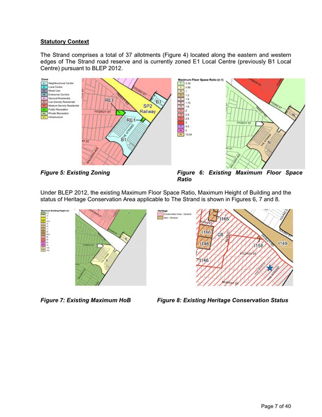
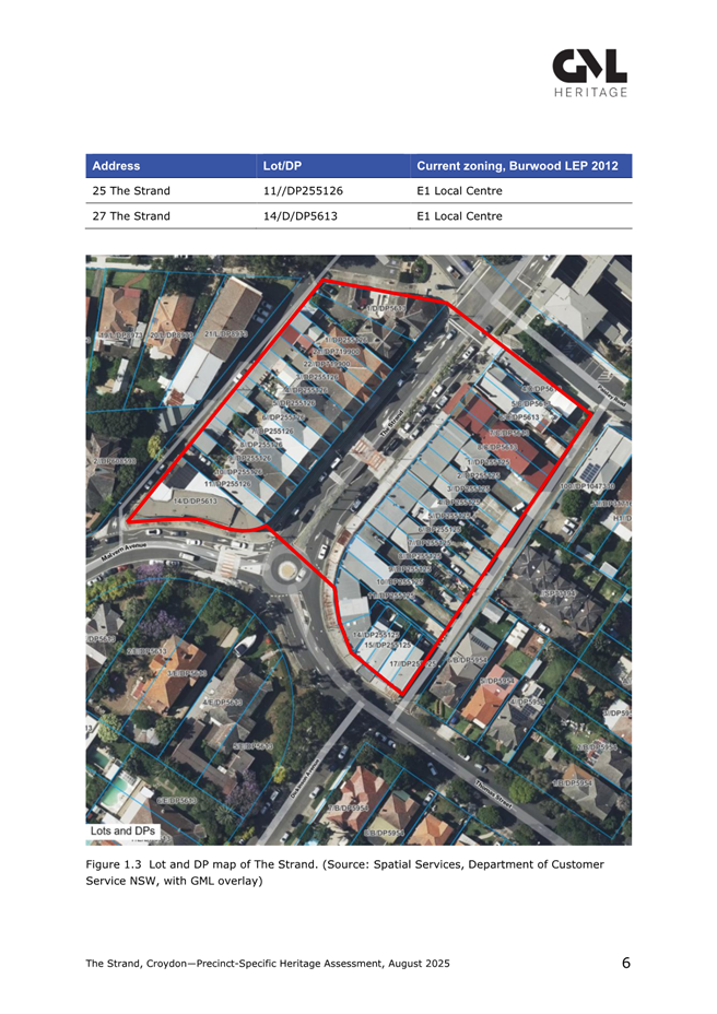
The Strand comprises a total of 37 allotments
(Figure 3) located along the eastern and western edges of The Strand road
reserve and is currently zoned E1 Local Centre (previously B1 Local
Centre) pursuant to BLEP 2012.
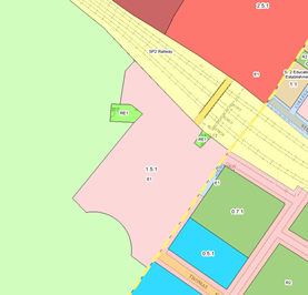
Under BLEP
2012, the existing Maximum Floor Space Ratio, Maximum Height of Building and
the status of Heritage Conservation Area applicable to The Strand is shown in
Figures 6, 7 and 8.
|
|
|
|
Figure 6: Existing
Maximum Height of Building
(Source: NSW Eplanning
Spatial Viewer)
|
Figure 7: Existing
Heritage Conservation Status of the Strand
(Source: NSW
Legislation website)
|
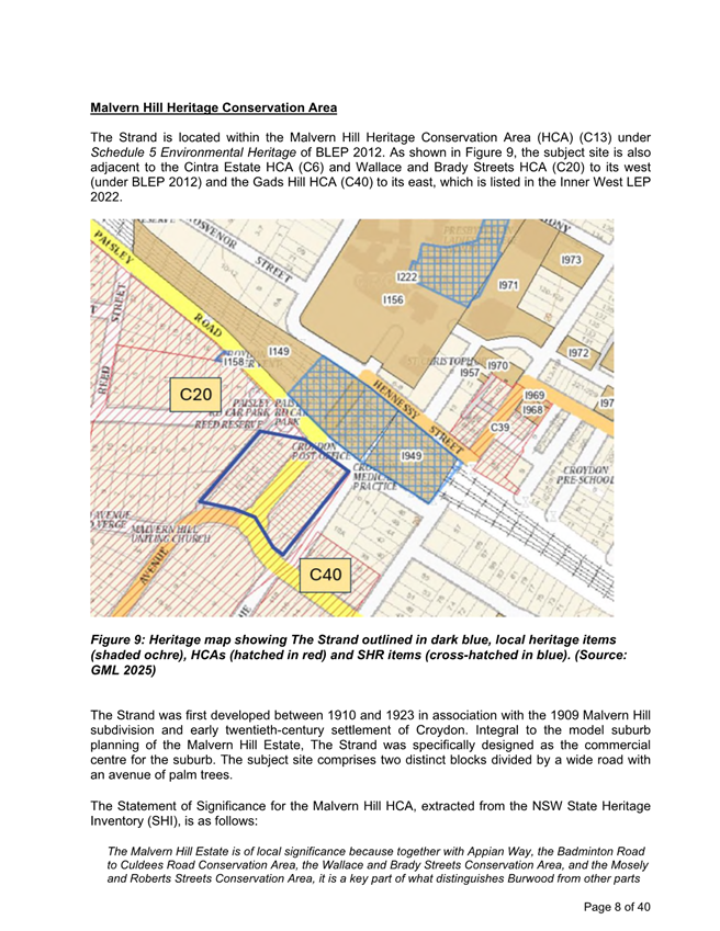
Malvern
Hill Heritage Conservation Area
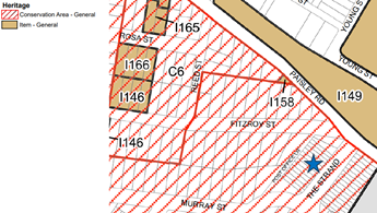
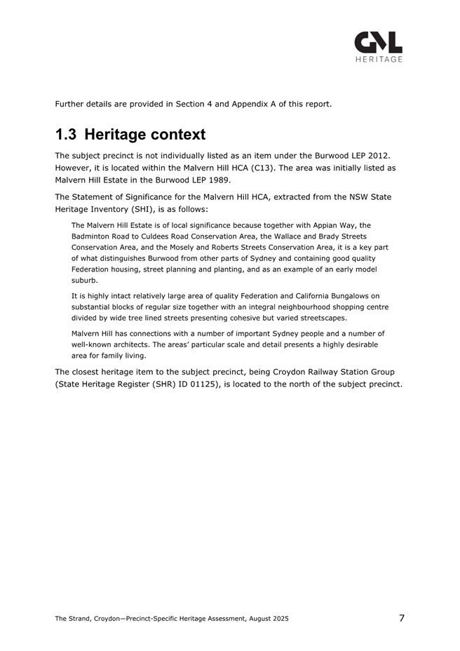
The Strand is located within the Malvern Hill
Heritage Conservation Area (HCA) (C13) under Schedule 5 Environmental
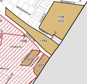
Heritage of BLEP 2012. As shown in Figure 8, the subject site is also adjacent to
the Cintra Estate HCA (C6) and Wallace and Brady Streets HCA (C20) to its west
(under BLEP 2012) and the Gads Hill HCA (C40) to its east, which is listed in
the Inner West LEP 2022.
Figure 8: Heritage map showing The Strand outlined in dark
blue, local heritage items (shaded ochre), HCAs (hatched in red) and SHR items
(cross-hatched in blue). (Source: GML 2025)
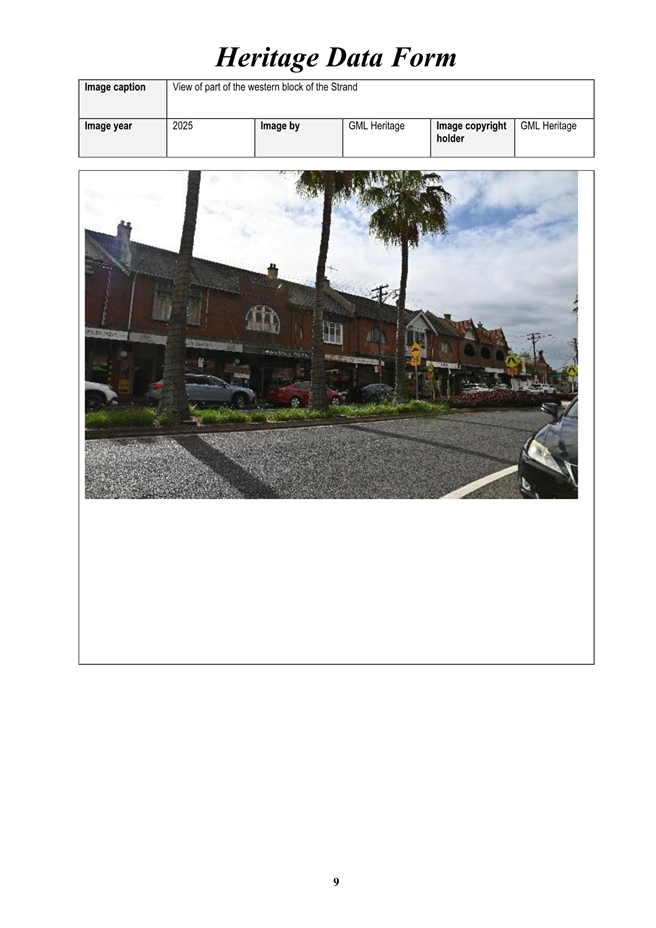
The Strand
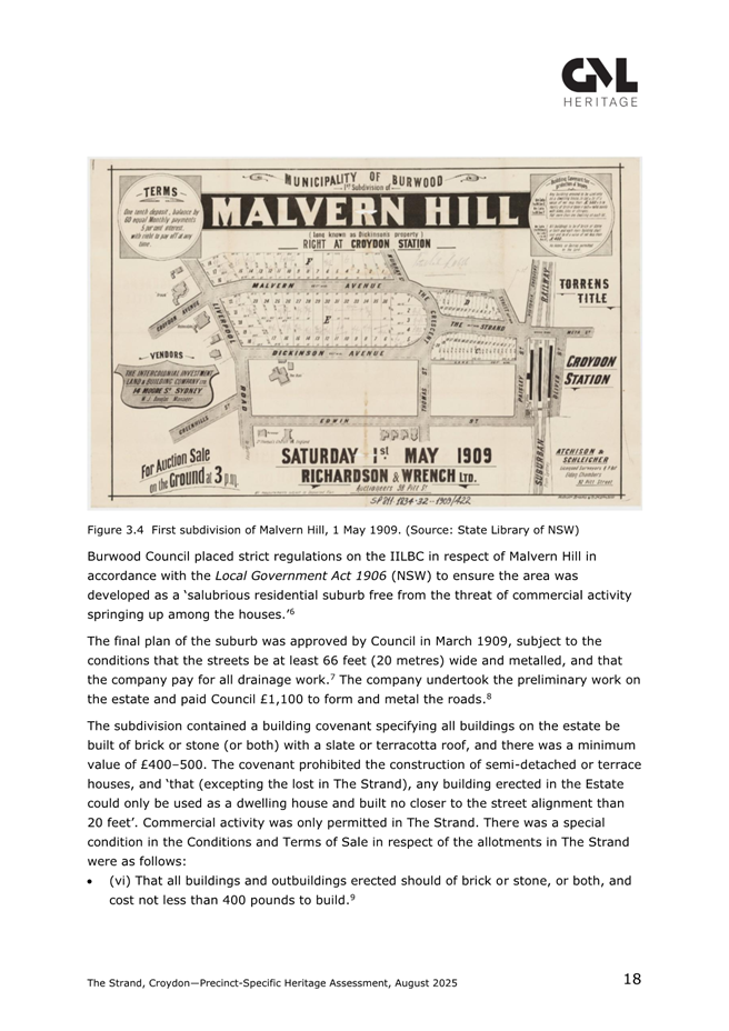
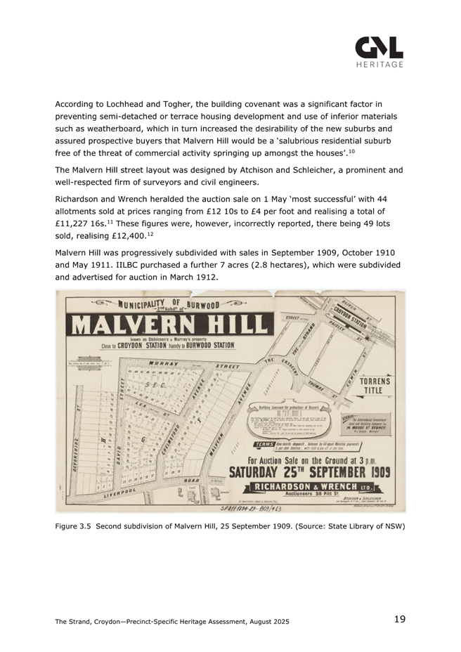
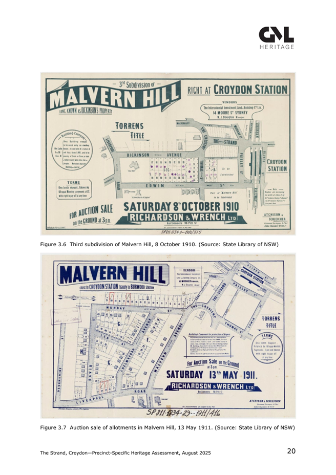
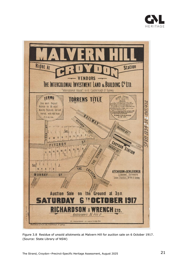
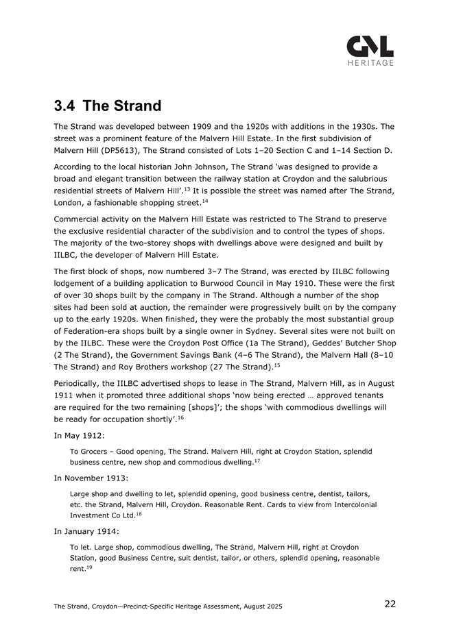
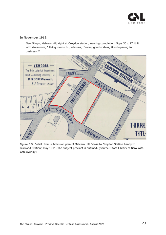
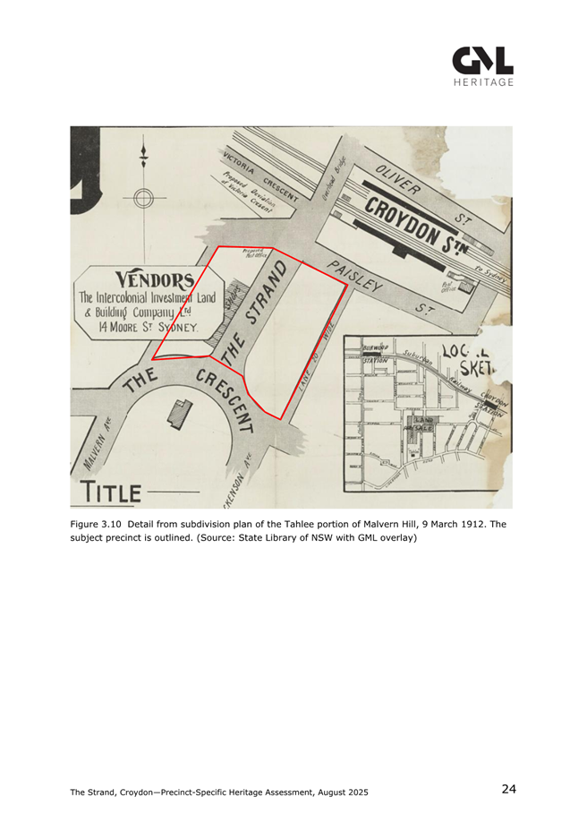
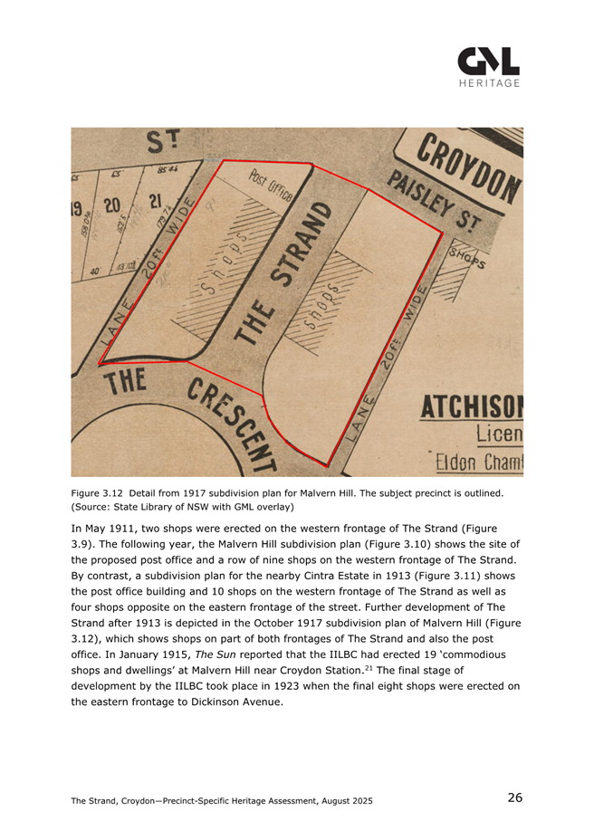
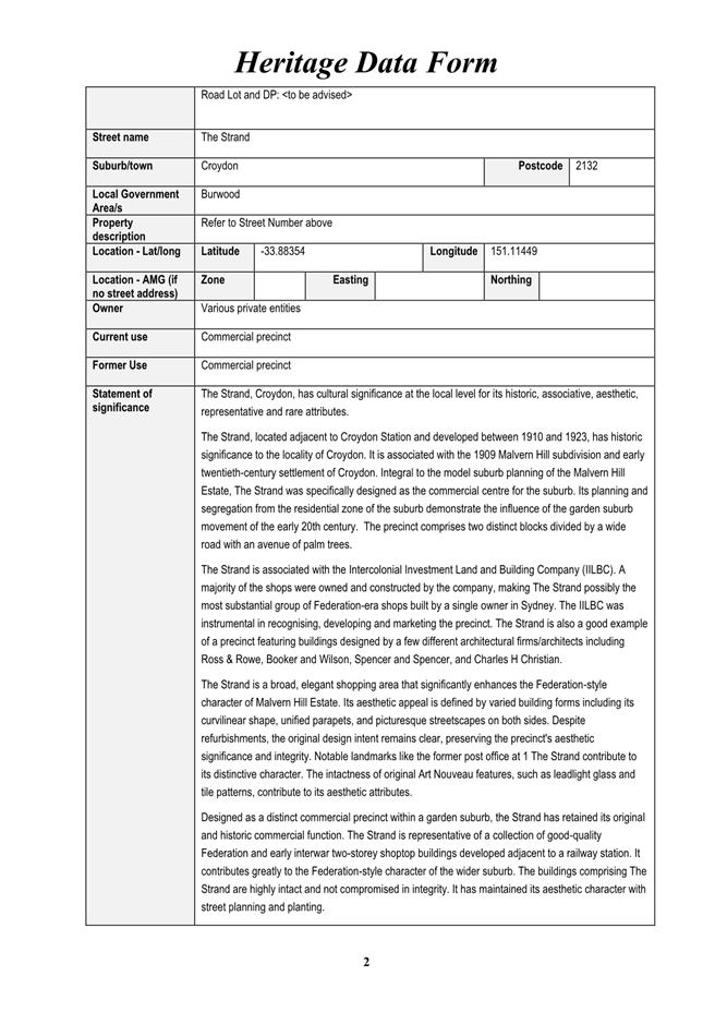
was first developed between 1910 and 1923 in association with the 1909 Malvern
Hill subdivision and early twentieth-century settlement of Croydon. Integral to
the model suburb planning of the Malvern Hill Estate, The Strand was
specifically designed as the commercial centre for the suburb. The subject site
comprises two distinct blocks divided by a wide road with an avenue of palm
trees.
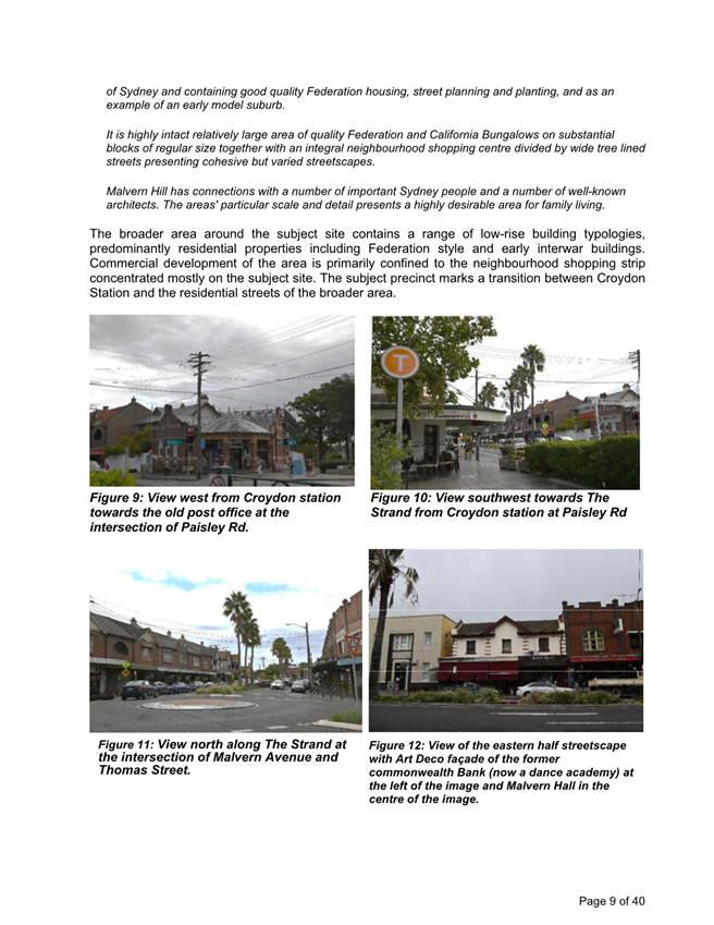
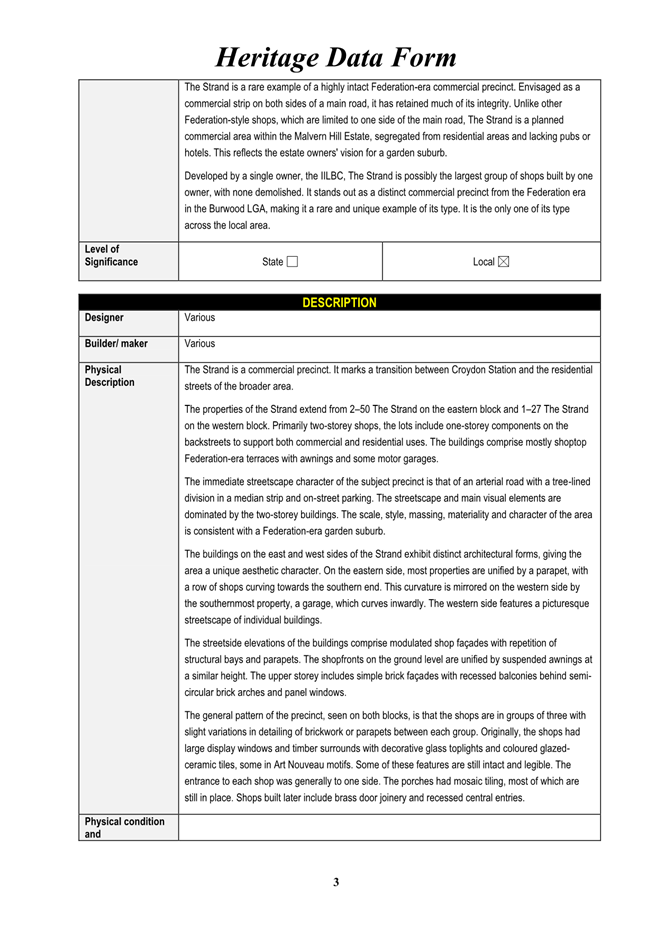
The broader
area around the subject site contains a range of low-rise building typologies,
predominantly residential properties including Federation style and early
interwar buildings. Commercial development of the area is primarily confined to
the neighbourhood shopping strip concentrated mostly on the subject site. The
subject precinct marks a transition between Croydon Station and the residential
streets of the broader area.
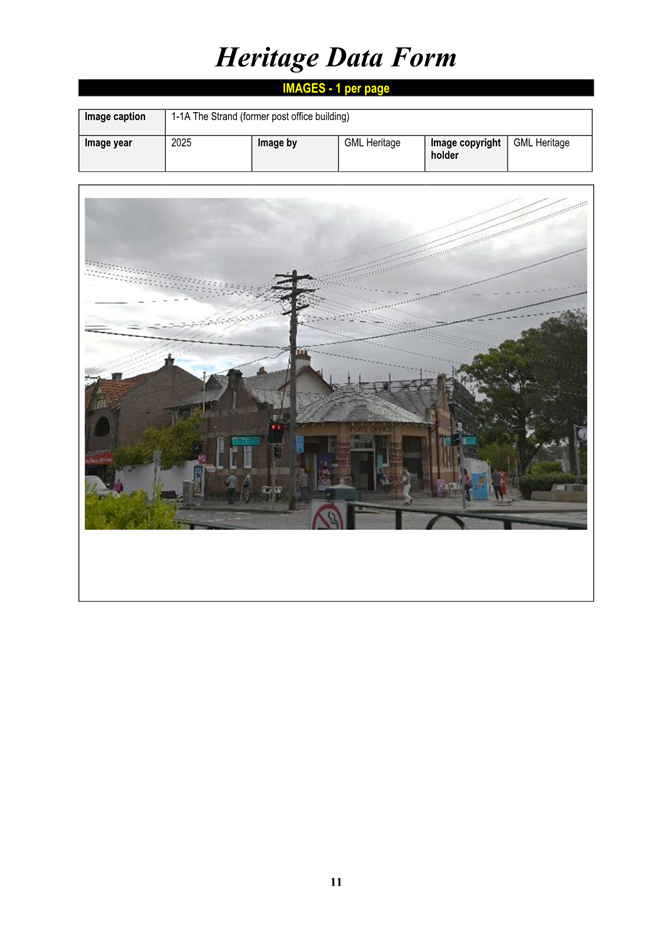
|
|
|
|
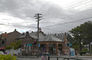
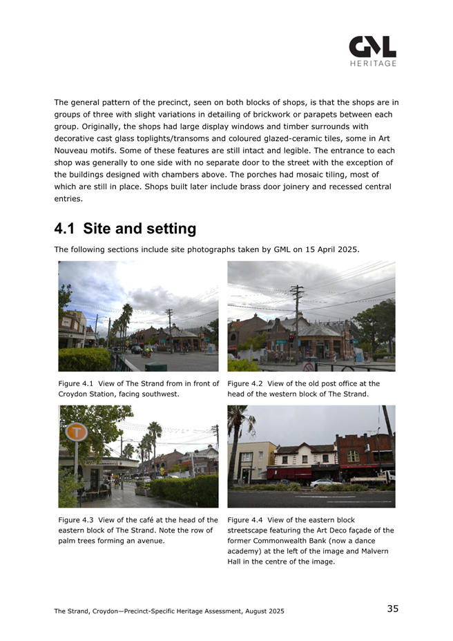
Figure 9: View west from Croydon station towards
the old post office at the intersection of Paisley Rd.
|
Figure 10: View southwest towards The Strand
from Croydon station at Paisley Rd
|
|
|
|
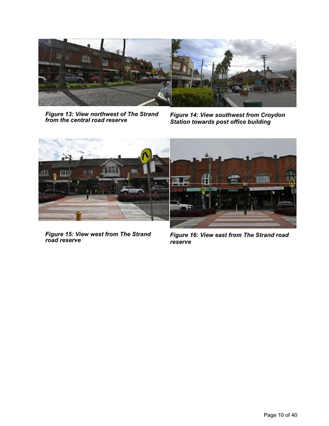
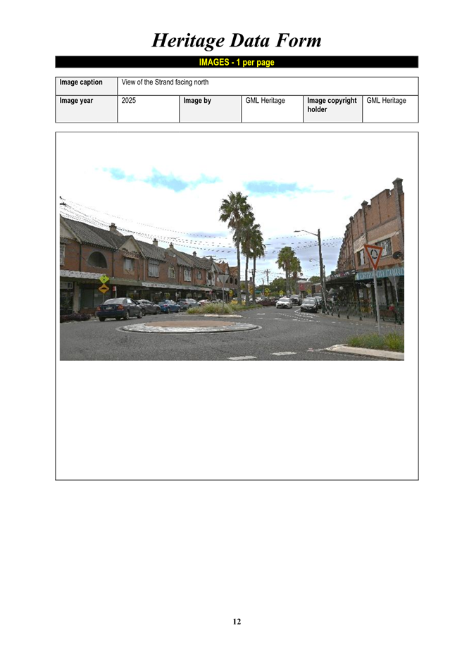
|
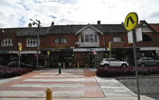
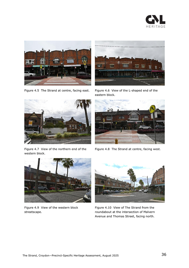
Figure 11: View north along The Strand at the
intersection of Malvern Avenue & Thomas Street.
|
Figure 12: The Strand road reserve, view west
|
The Planning
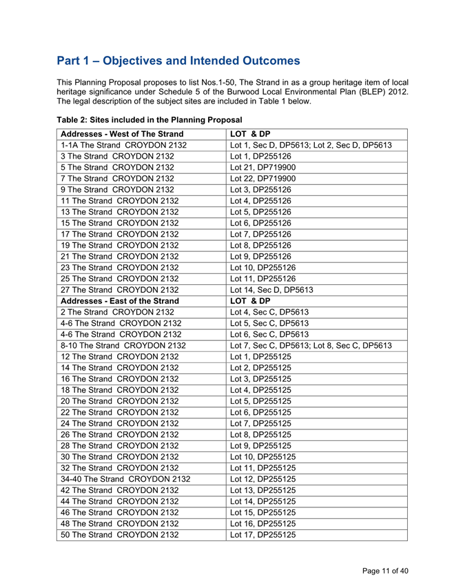
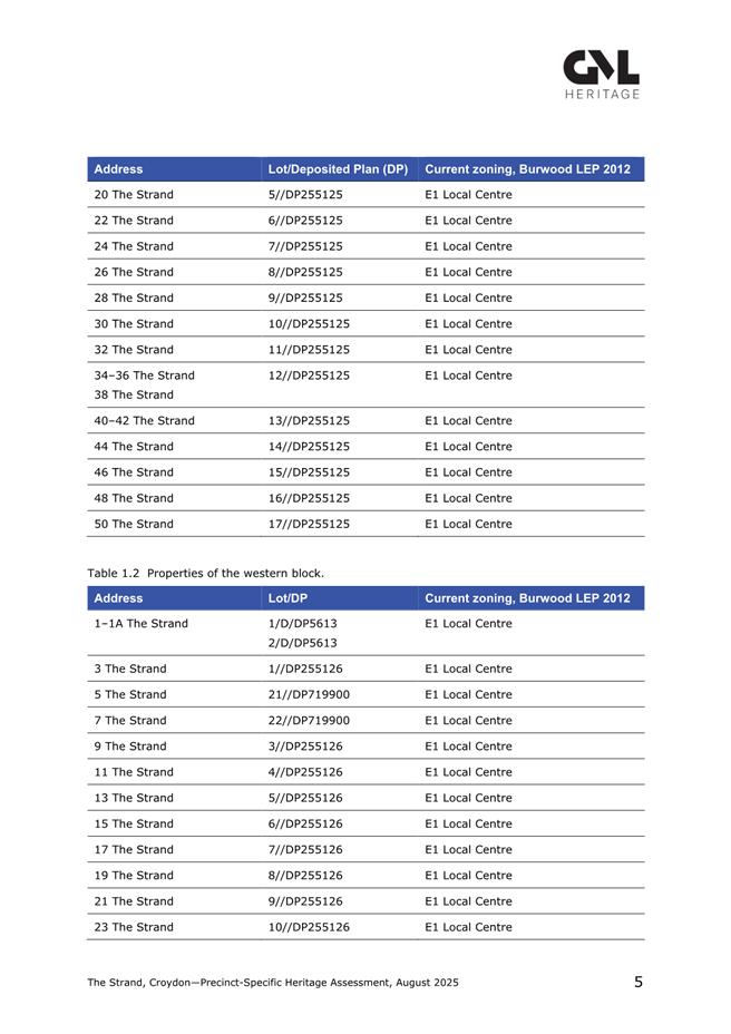
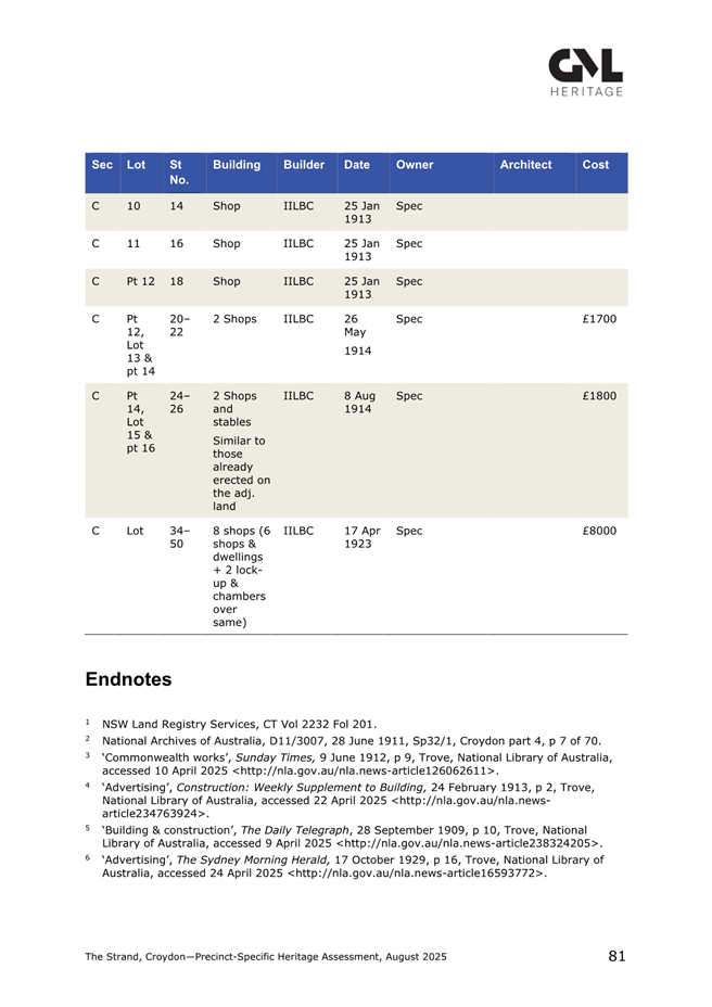
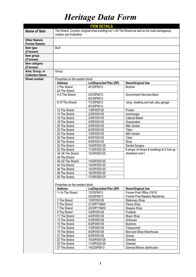
Proposal relates to the properties detailed in Table 1.
Table 1:
Legal description of The Strand, Croydon
|
Address (West of the Strand)
|
LOT & DP
|
Address (East of the Strand)
|
LOT & DP
|
|
1-1A The Strand
|
Lot 1, Sec D, DP5613; Lot 2, Sec
D, DP5613
|
2 The Strand
|
Lot 4, Sec C, DP5613
|
|
3 The Strand
|
Lot 1, DP255126
|
4-6 The Strand
|
Lot 5, Sec C, DP5613
|
|
5 The Strand
|
Lot 21, DP719900
|
4-6 The Strand
|
Lot 6, Sec C, DP5613
|
|
7 The Strand
|
Lot 22, DP719900
|
8-10 The Strand
|
Lot 7, Sec C, DP5613; Lot 8, Sec
C, DP5613
|
|
9 The Strand
|
Lot 3, DP255126
|
12 The Strand
|
Lot 1, DP255125
|
|
11 The Strand
|
Lot 4, DP255126
|
14 The Strand
|
Lot 2, DP255125
|
|
13 The Strand
|
Lot 5, DP255126
|
16 The Strand
|
Lot 3, DP255125
|
|
15 The Strand
|
Lot 6, DP255126
|
18 The Strand
|
Lot 4, DP255125
|
|
17 The Strand
|
Lot 7, DP255126
|
20 The Strand
|
Lot 5, DP255125
|
|
19 The Strand
|
Lot 8, DP255126
|
22 The Strand
|
Lot 6, DP255125
|
|
21 The Strand
|
Lot 9, DP255126
|
24 The Strand
|
Lot 7, DP255125
|
|
23 The Strand
|
Lot 10, DP255126
|
26 The Strand
|
Lot 8, DP255125
|
|
25 The Strand
|
Lot 11, DP255126
|
28 The Strand
|
Lot 9, DP255125
|
|
27 The Strand
|
Lot 14, Sec D, DP5613
|
30 The Strand
|
Lot 10, DP255125
|
|
|
32 The Strand
|
Lot 11, DP255125
|
|
34-40 The Strand
|
Lot 12, DP255125
|
|
42 The Strand
|
Lot 13, DP255125
|
|
44 The Strand
|
Lot 14, DP255125
|
|
46 The Strand
|
Lot 15, DP255125
|
|
48 The Strand
|
Lot 16, DP255125
|
|
50 The Strand
|
Lot 17, DP255125
|
|
|
|
|
Figure 14: Existing Heritage Map
|
Figure 15: Proposed Heritage Map
|
Table 2: Proposed addition to
Schedule 5 of Burwood LEP 2012
|
Suburb
|
Item name
|
Address
|
Property description
|
Significance
|
Item no
|
|
Burwood
|
The Strand
|
1-50 The
Strand, Croydon 2132
|
See Table 1
for property description
|
Local
|
I237*
|
* Heritage Item Nos. are indicative only at this stage and
are to be confirmed at finalisation.
Heritage Assessment
In April 2025, Council engaged a qualified heritage
consultant, GML Heritage to seek independent heritage on the heritage
significance of The Strand, Croydon.
The heritage assessment report (Attachment 2)
completed by GML includes an assessment of significance of the subject
properties in accordance with the standard criteria established in the NSW
Heritage Office guidelines. These guidelines provide the framework for heritage
assessment and incorporate the seven criteria of cultural heritage values
identified in the Burra Charter into a structured framework.
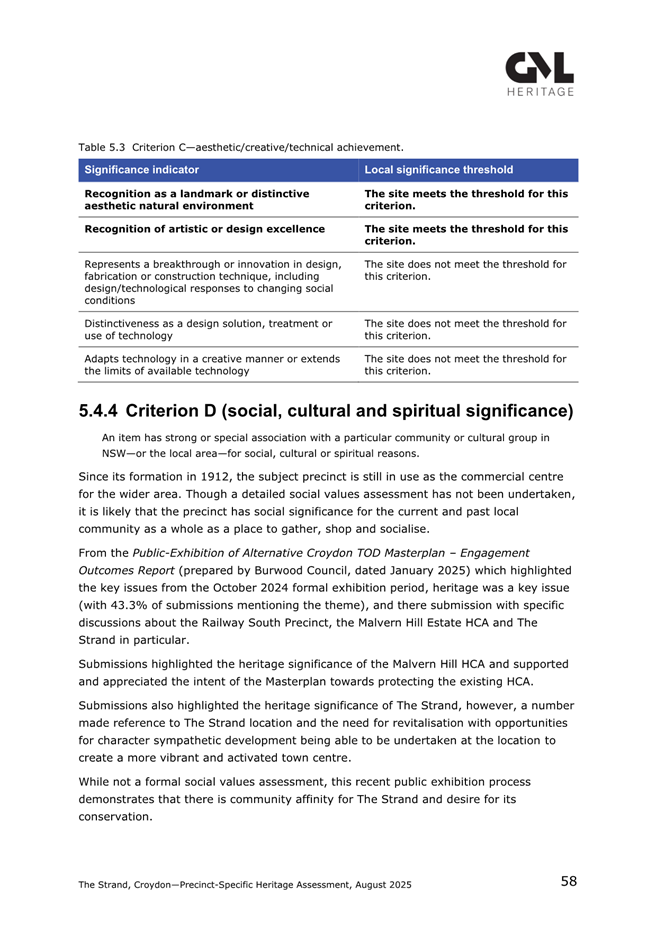
Table 4 below provides a summary of heritage
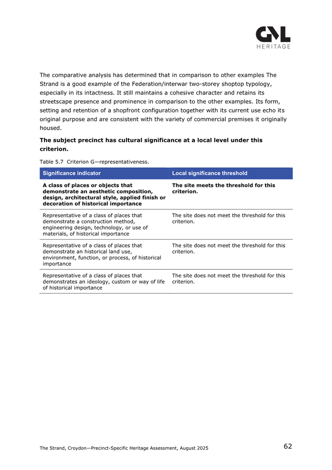
assessment of The Strand against the assessment framework demonstrating
that The Strand satisfies multiple heritage assessment criteria for its local group heritage listing.
Table
4: NSW Heritage Assessment Criteria applying to The Strand
|
NSW
Heritage Criteria for local listing
|
The
Strand
|
|
Criterion
(A) Historical Significance
The Strand meets the threshold for Criterion (A) Historical
Significance with the following significance indicator:
· Demonstration of important periods or phases in history
|
Yes
|
|
Criterion
(B) Historical Association
The Strand
meets the threshold for Criterion (B) Historical Association with the
following significance indicator:
· A key phase(s) in the
establishment or subsequent development at the place or object was undertaken
by, or directly influenced by, the important person(s) or organisation.
· An event or series of
events of historical importance occurring at the place or object were
undertaken by, or directly influenced by, the important person(s) or
organization.
|
Yes
|
|
Criterion
(C) Aesthetic/Technical Significance
The Strand meets the threshold for Criterion (C) Aesthetic or Technical Significance with the following
significance indicator:
· Recognition as a
landmark or distinctive aesthetic natural environment.
· Recognition of
artistic or design excellence.
|
Yes
|
|
Criterion
(D) Social, Cultural and Spiritual Significance
The Strand meets the
threshold for Criterion (C) Aesthetic or Technical Significance with the
following significance indicator:
· Highly regarded by a community as a
key landmark (built feature, landscape or streetscape) within the physical
environment.
· Important to the community as a
landmark within social and political history
· Important as a place of symbolic
meaning and community identity.
· Important as a place of community
service (including health, education worship, pastoral care, communications,
emergency services, museums).
|
Yes
|
|
Criterion
(E) Research Potential
No
sufficient evidence is currently present to satisfy this criterion.
|
No
|
|
Criterion (F) Rarity
The Strand
meets the threshold for Criterion (F) Rarity due
to the following significance indicator:
· Distinctiveness in demonstrating an
unusual historical, natural, architectural, archaeological, scientific,
social or technical attribute(s) that is of special interest.
|
Yes
|
|
Criterion (G)
Representativeness
The Strand meets the threshold for Criterion
(G) Representativeness with the following
significance indicator:
· A class of places or objects that demonstrate an aesthetic
composition, design, architectural style, applied finish or decoration of
historical importance.
|
Yes
|
|
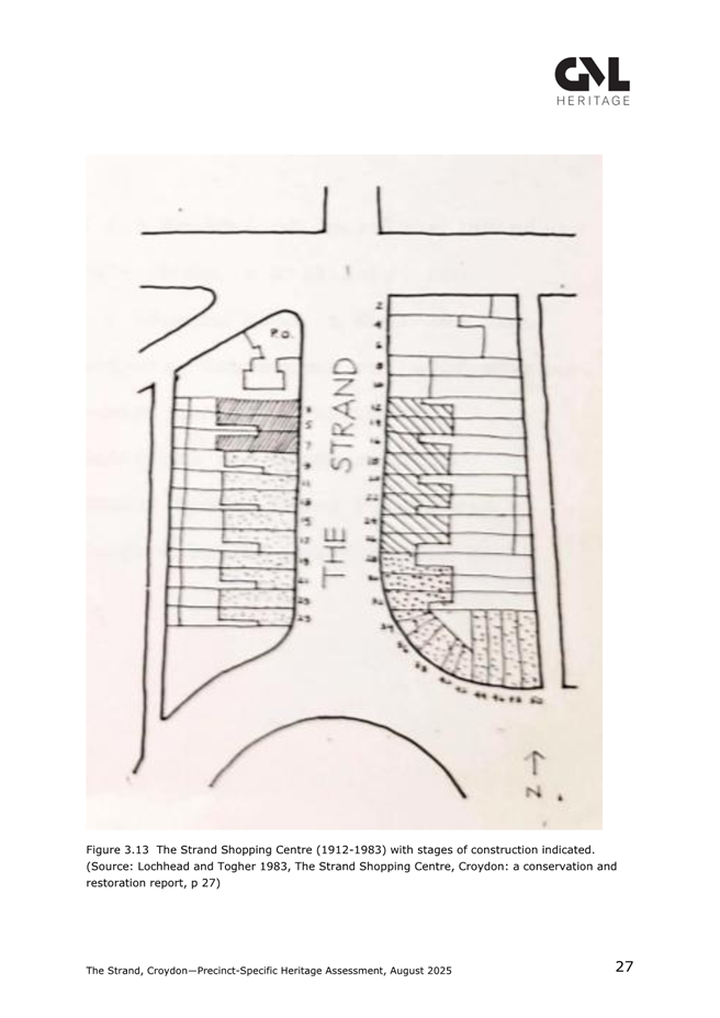
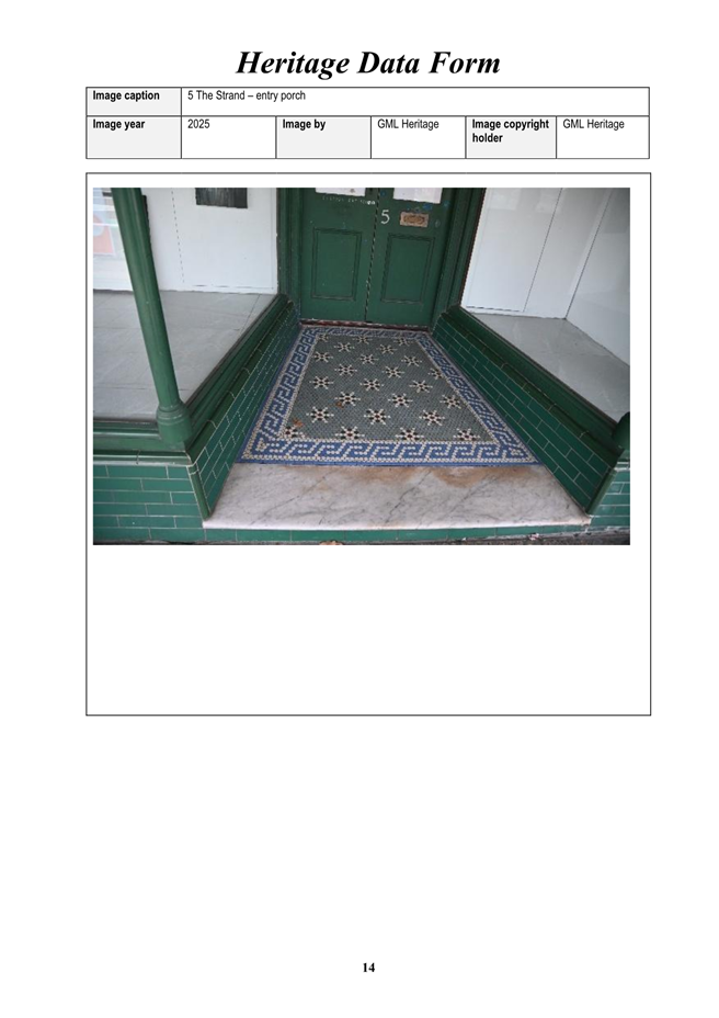
Integrity
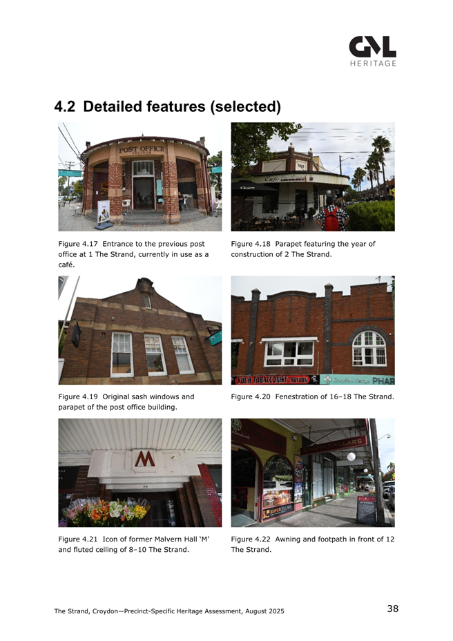
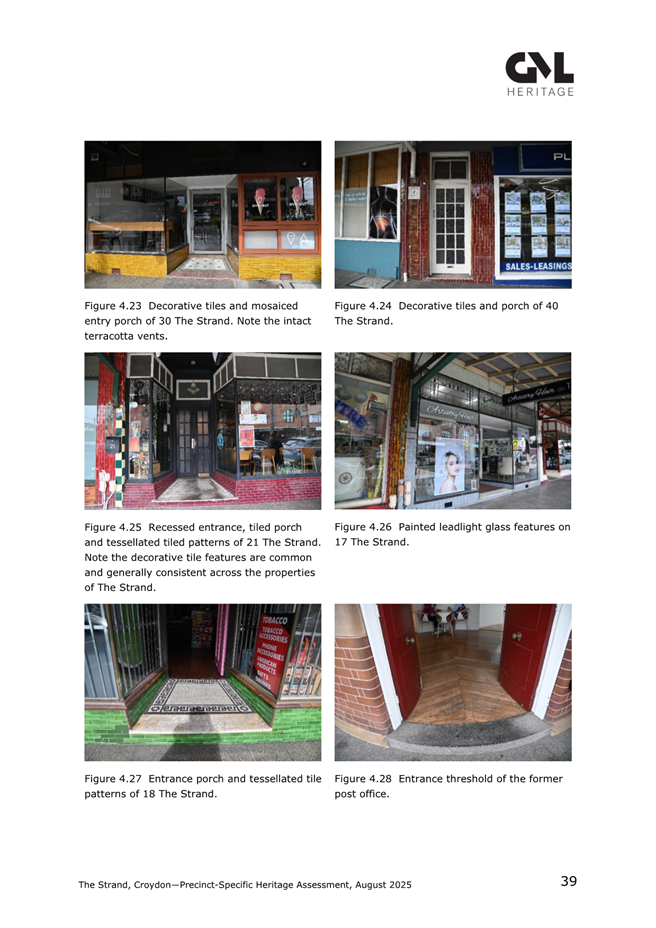
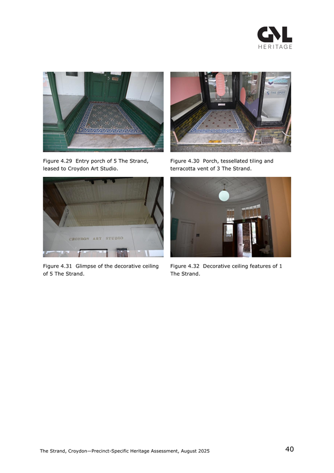
The setting and context of The Strand have
remained unchanged since the development of its buildings. The planned layout
of the pedestrian realm and central avenue of trees is still extant and adds
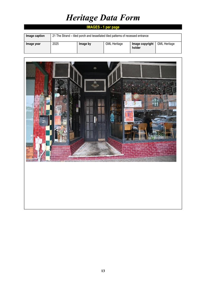
to the character of the precinct. The buildings vary in integrity. Most
shopfronts on the northern side of the road are intact. Features including
pressed metal ceilings have been retained. All of the shops have been altered
at ground level with changes in use and tenancy. However, in general, most
buildings retain some original features such as ceramic tiled front porches
with Art Nouveau motifs, tessellated tile patterns, brass sashes around
windows, leadlight glazing and terracotta vents.
The
upper-storey fabric is mostly intact across all buildings. No new openings
and limited infills were noted for the upper storeys of the buildings.
Features such as recessed facades in arches, original sash windows, parapets
and details in brickwork remain intact and legible. The buildings can be
considered to have integrity consistent with original design, composition and
external materiality. Overall, the planned layout of The Strand and the
Federation-style character of its buildings remain highly legible.
|
Yes
|
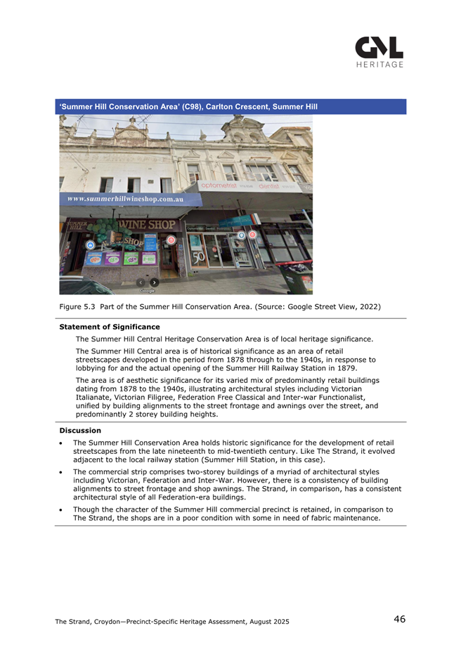
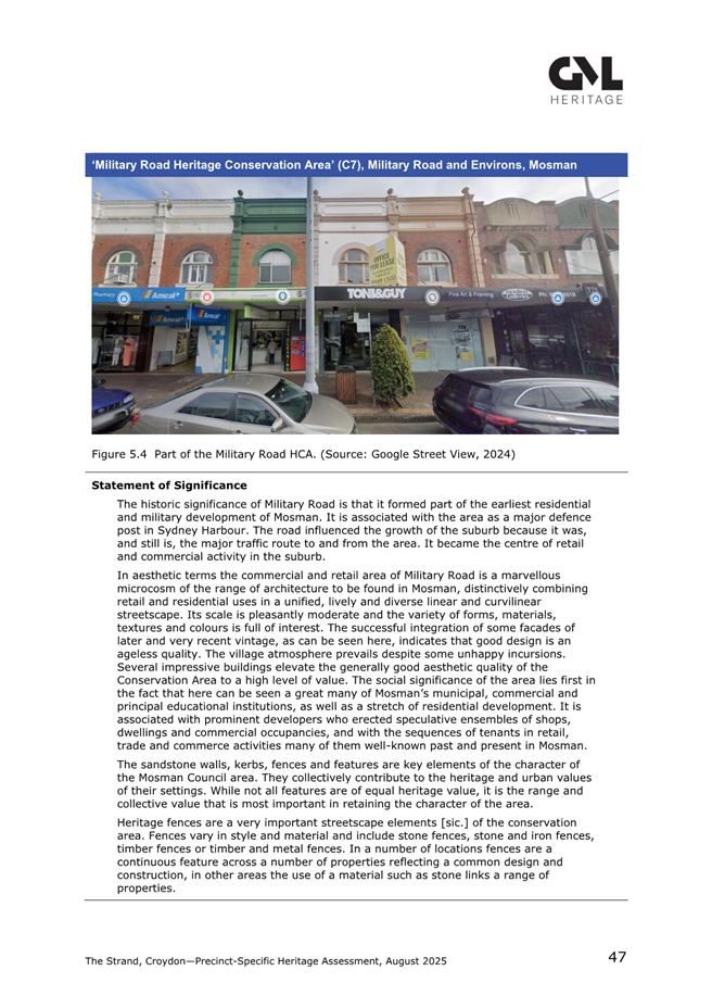
Heritage Statement of Significance – The Strand, Croydon
The assessment undertaken by GML recommends the following as the key
evidence and support for heritage significance of The Strand:
· The
Strand, Croydon meets the threshold for heritage listing under the historic,
associative, aesthetic, social, representative and rare criterion of the NSW
Heritage Assessment Criteria. These attributes are contributory to, but
distinct from, the values of the Malvern Hill HCA as a whole.
· The Strand,
located adjacent to Croydon Station and developed between 1910 and 1923, has
historic significance to the locality of Croydon. It is associated with the
1909 Malvern Hill subdivision and early twentieth-century settlement of
Croydon. Integral to the model suburb planning of the Malvern Hill Estate, The
Strand was specifically designed as the commercial centre
for the suburb. Its planning and segregation from the residential zone of the
suburb demonstrate the influence of the garden suburb movement of the early
20th century. The precinct comprises two distinct blocks divided by a wide road
with an avenue of palm trees.
· The Strand is
associated with the Intercolonial Investment Land and Building Company (IILBC).
Most of the shops were owned and constructed by the company, making The Strand
possibly the most substantial group of Federation-era shops built by a single
owner in Sydney. The IILBC was instrumental in recognising, developing and
marketing the precinct. The Strand is also a good example of a precinct
featuring buildings designed by a few different architectural firms/architects
including Ross & Rowe, Booker and Wilson, Spencer and Spencer, and Charles
H Christian.
· The Strand is a
broad, elegant shopping area that significantly enhances the Federation-style
character of Malvern Hill Estate. Its aesthetic appeal is defined by varied
building forms including its curvilinear shape, unified parapets, and
picturesque streetscapes on both sides. Despite refurbishments, the original
design intent remains clear, preserving the precinct's aesthetic significance
and integrity. Notable landmarks like the former post office at 1 The Strand
contribute to its distinctive character. The intactness of original Art Nouveau
features, such as leadlight glass and tile patterns, contribute to its
aesthetic attributes.
· Designed as a
distinct commercial precinct within a garden suburb, The Strand has retained
its original and historic commercial function. The Strand is representative of
a collection of good-quality Federation and early interwar two-storey, shop top
buildings developed adjacent to a railway station. It contributes greatly to
the Federation-style character of the wider suburb. The buildings comprising
The Strand are highly intact and not compromised in integrity. It has
maintained its aesthetic character with street planning and planting.
· The Strand has
social value as a community centre which has been a place to gather, shop and
socialise since the 20th century.
· While not a formal
social values assessment, the recent public exhibition process of the
Alternative Croydon TOD Masterplan demonstrates that there is community
affinity for The Strand and desire for its conservation.
· The Strand is a
rare example of a highly intact Federation-era commercial precinct. Envisaged
as a commercial strip on both sides of a main road, it has retained much of its
integrity. Unlike other Federation-style shops, which are limited to one side
of the main road, The Strand is a planned commercial area within the Malvern
Hill Estate, segregated from residential areas and lacking pubs or hotels. This
reflects the estate owners' vision for a garden suburb.
· Developed by a
single owner, the IILBC, The Strand is possibly the largest group of shops
built by one owner, with none demolished. It stands out as a distinct
commercial precinct from the Federation era in the Burwood LGA, making it a
rare and unique example of its type. It is the only one of its type across the
local area.
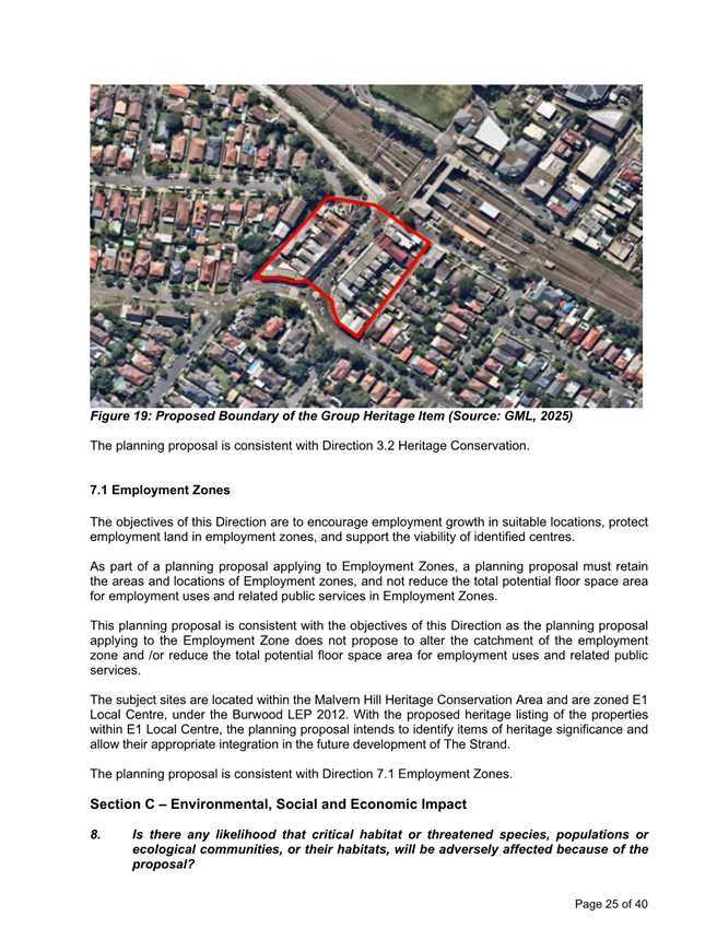
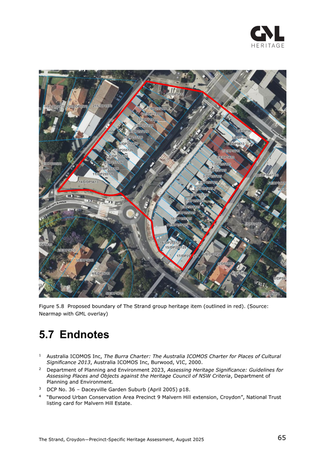
Proposed Boundary of the Group Heritage Item
The proposed
heritage boundary of The Strand is shown in Figure 16 which takes into
consideration significant views of The Strand, its setting and contextual
relationships with its surrounding.
Located
adjacent to Croydon Station, The Strand exhibits strong aesthetic qualities
that contribute to its setting and broader context. Notable views include the
southwest vista from the railway station, which frames the former Post Office
(No. 1 The Strand) and the former Butchery (No. 2 The Strand) at the junction
of The Strand.
Figure
16: Proposed Boundary of the Group Heritage Item
(Source: GML, 2025)
These
landmark buildings function as visual markers and provide a principal entry
point into the commercial precinct. While views from the south are of lesser
significance, the presentation of each streetscape along The Strand contributes
to the overall character of the precinct.
Consistency
with State and Local Planning Policies
A detailed assessment demonstrating the strategic and site-specific merit of the Planning Proposal
and its consistency with the applicable State and Local Planning Policies is
included in Attachment 2. This section highlights some of the key matters of
the assessment:
· The Planning Proposal is consistent with the key objectives
and priorities of the Greater Sydney Region Plan: A Metropolis of Three Cities
and the Eastern City District Plan via identification of The Strand as an
‘environmental heritage’ in BLEP 2012 for its statutory protection.
· The Planning Proposal is consistent with Council’s
Community Strategic Plan (CSP) and Burwood Local Strategic Planning Statement
(LSPS) as the proposal ensures local character is protected and enhanced via
listing of The Strand in the BLEP heritage schedule.
· The Planning Proposal is consistent with Council’s
Housing Strategy in enabling The Strand to transform in the future to meet the
changing community needs; achieve vibrancy, vitality and rejuvenation whilst
allowing the intrinsic value and heritage significance of The Strand being
appropriately acknowledged and celebrated via the local listing.
· This Planning Proposal is consistent with the objectives of
Burwood LEP 2012 in conserving environmental heritage via its listing on the
heritage Schedule and providing statutory protection through Clause 5.10
Heritage Conservation of the LEP.
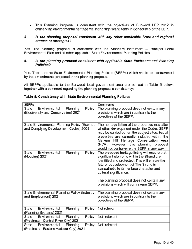
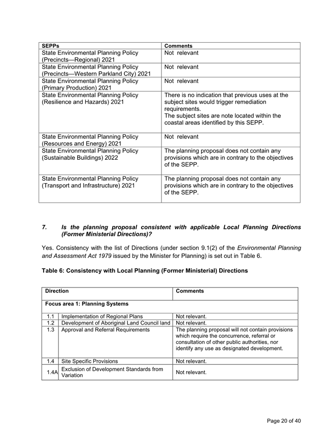
· The Planning Proposal is consistent with the applicable
State Environmental Planning Policies (SEPPs) and Local Planning Directions
(formerly known as Ministerial Directions) and are detailed in the attached
Planning Proposal (Attachment 2). Some of the most relevant SEPPs and Local
Planning Directions are listed below:
§ Consistent with SEPP (Exempt and Complying Development Codes) 2008: The
proposal does not contravene the intent of the SEPP as The Strand is part of
the Malvern Hill Heritage Conservation Area.
§ Consistent with SEPP (Housing) 2021: The proposal ensures significant
elements within The Strand are identified and protected so that any future
development is sympathetic to its heritage character and cultural significance.
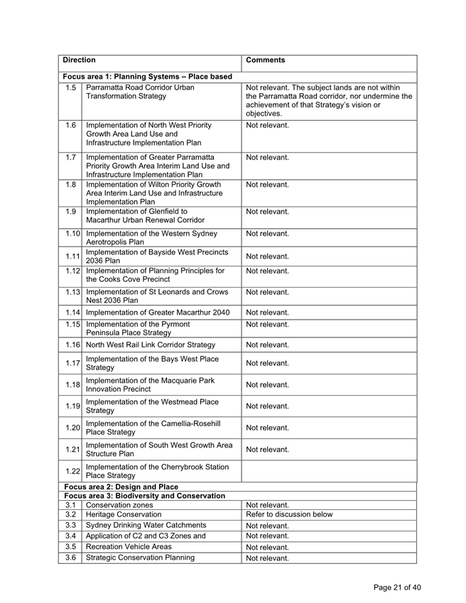
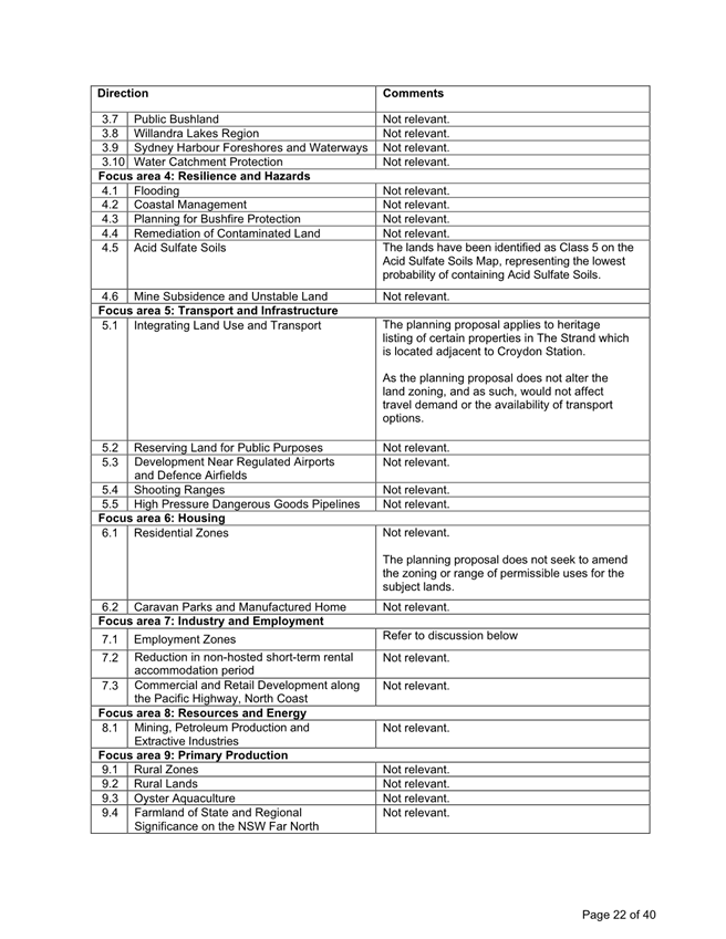
§ Consistent with Local Planning Direction 3.2 Heritage Conservation:
Clause 5.10 Heritage Conservation of BLEP 2012 would apply to the subject sites
following the gazettal of the PP, providing statutory protection.
§ Consistent with Local Planning Direction 7.1 Employment Zones: The
planning proposal applying to the Employment Zone does not propose to alter the
extent of the employment zone and /or reduce the total potential space area for
employment uses.
Consultation
On 15 August 2025, early engagement notification letters
were sent out to the property owners in The Strand who would be directly
impacted by the proposed heritage listing. The intent of the notification
letter was to inform the property owners of Council resolution of 29 January
2025, the Heritage Assessment report prepared by GML and the commencement of
pre-engagement for the proposed group heritage listing.
The objective of undertaking early engagement was to gather
feedback from the affected property owners and the wider community on the
proposed group heritage listing of The Strand prior
to reporting the matter to the Burwood Local Planning Panel.
A dedicated section was established on Council’s online
platform, Participate Burwood with the following documents being
displayed for review and submission:
· Heritage Assessment Report of the
Strand, GML Aug 2025
· Draft Heritage Inventory Sheet,
GML Aug 2025
· Site Identification Map
· Proposed amendments to the Heritage
Map of the Burwood LEP 2012
Email correspondence was sent to Inner West Council, the
Burwood & District Historical Society, and local Councillors to advise them
of the proposed group heritage listing and the accompanying GML report, and to
invite their feedback.
Early engagement commenced
on 18 August and concluded on 22 September 2025. During this period, a total of
23 submissions were received. 19 submissions were received via online Participate
Burwood platform, and (4) four submissions were received as direct email
correspondence to Council which included the submissions from the Burwood & District Historical Society and the NSW
National Trust of Australia.
None of the submissions received objected to the proposed
group heritage listing of The Strand. A detailed submissions register and
Council’s response to the submissions are included in Attachment 4.
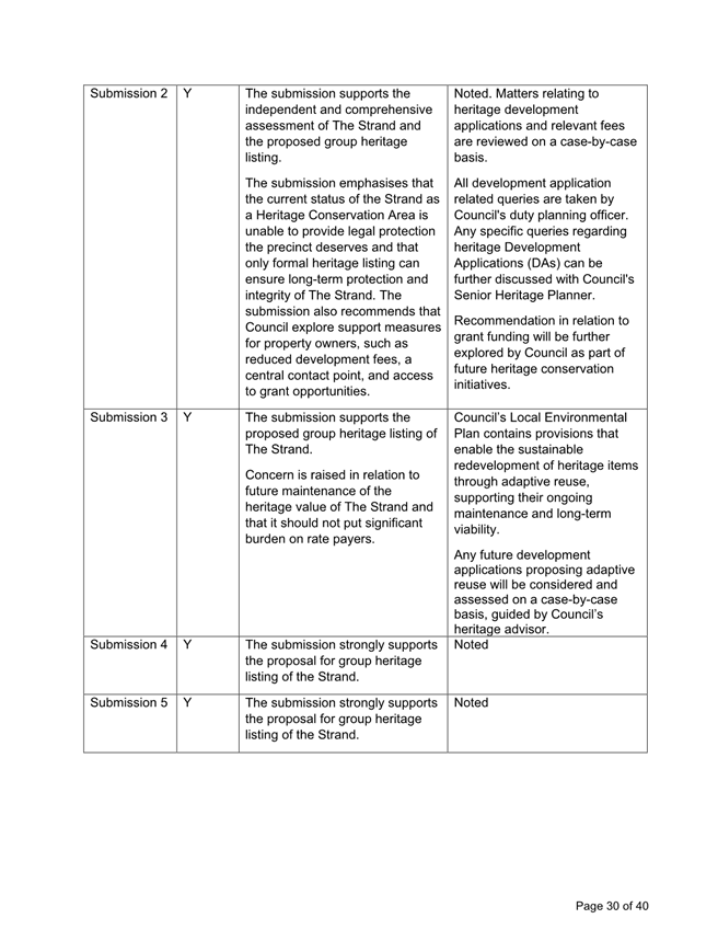
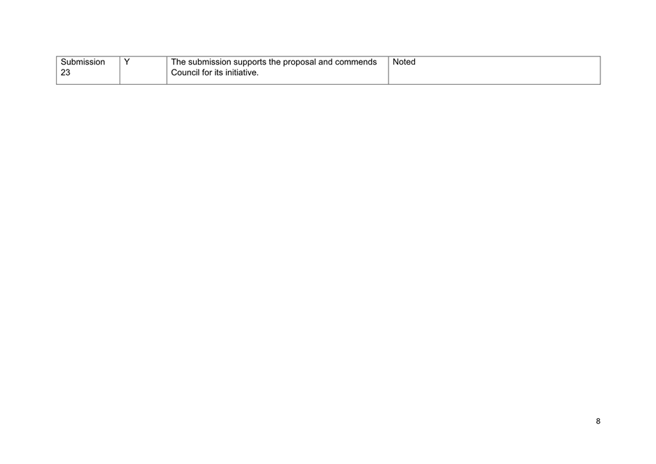
Some of the key matters noted in the submissions are summarised in Table 5
below:
Table
5: Summary of key matters noted in early engagement submissions
|
Summary of key matters
|
Council response
|
|
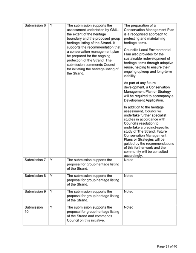
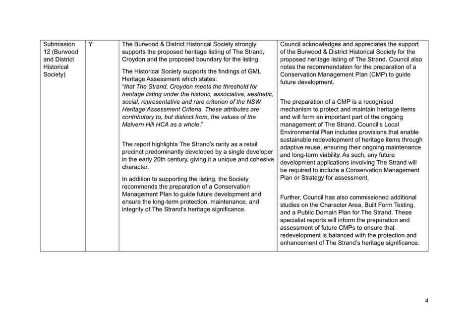
The submission supports the independent and
comprehensive assessment of The Strand and the proposed group heritage
listing.
The submission emphasises that the current status of The
Strand as a Heritage Conservation Area is unable to provide the legal
protection the precinct deserves and that only formal heritage listing can
ensure long-term protection and integrity of The Strand.
The submission also recommends that Council explore
support measures for property owners, such as reduced development fees, a
central contact point, and access to grant opportunities.
|
Noted. Matters relating to heritage development
applications and relevant fees are reviewed on a case-by-case basis.
All development application related queries are
taken by Council's duty planning officer. Any specific queries regarding
heritage Development Applications (DAs) can be further discussed with
Council's Senior Heritage Planner.
Recommendation in relation to grant funding will be
further explored by Council as part of future heritage conservation
initiatives.
|
|
The submission supports the proposed group heritage
listing of The Strand.
Concern is raised in relation to future maintenance of the
heritage value of The Strand and that it should not put significant burden on
rate payers.
|
Council’s Local Environmental Plan contains
provisions that enable the sustainable redevelopment of heritage items
through adaptive reuse, supporting their ongoing maintenance and long-term
viability.
Any future development applications proposing adaptive
reuse will be considered and assessed on a case-by-case basis, guided by
Council’s heritage advisor.
|
|
The submission supports the assessment undertaken by GML,
the extent of the heritage boundary and the proposed group heritage listing
of The Strand.
It supports the recommendation that a conservation
management plan be prepared for the ongoing protection of The Strand. The
submission commends Council for initiating the heritage listing of The
Strand.
|
The preparation of a Conservation Management Plan is
a recognised approach to protecting and maintaining heritage items.
Council’s Local Environmental Plan also
provides for the sustainable redevelopment of heritage items through adaptive
reuse, helping to ensure their ongoing upkeep and long-term viability.
As part of any future development, a Conservation
Management Plan or Strategy will be required to accompany a Development
Application.
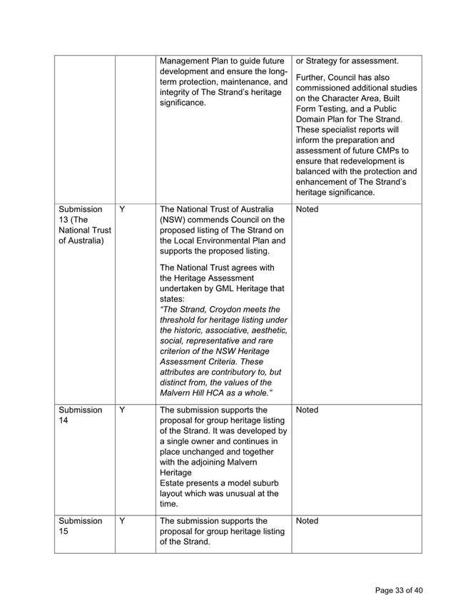
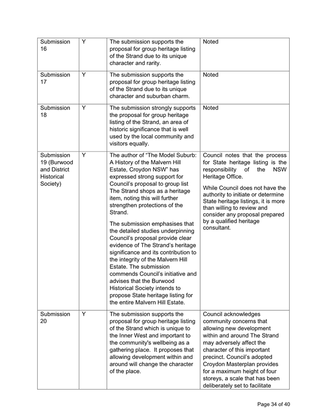
In addition to the heritage assessment, Council will
undertake further specialist studies in accordance with Council’s
resolution to undertake a precinct-specific study of The Strand. Future
Conservation Management Plans or Strategies will be guided by the
recommendations of this further work, and the community will be consulted
accordingly.
|
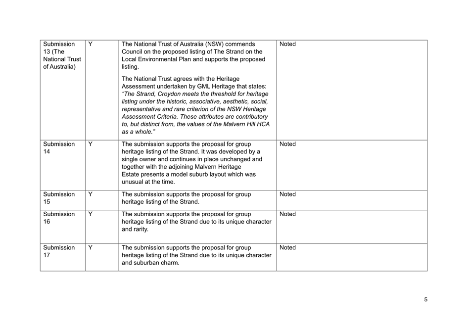
|
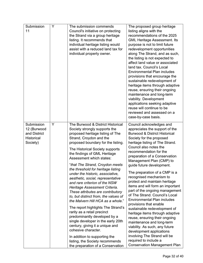
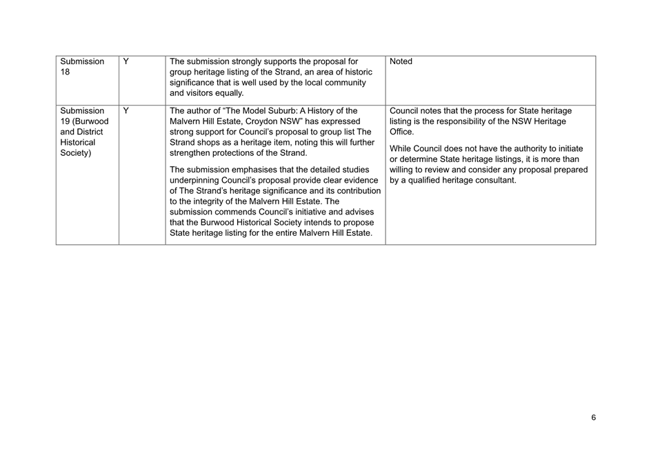
The submission provides strong support for
Council’s proposal to group list The Strand shops as a heritage item,
noting this will further strengthen protections of The Strand.
The submission emphasises that the detailed studies
underpinning Council’s proposal provide clear evidence of The
Strand’s heritage significance and its contribution to the integrity of
the Malvern Hill Estate.
The submission commends Council’s initiative and
proposes State heritage listing for the entire Malvern Hill Estate.
|
Council notes the comment received and notes that
the process for State heritage listing and determination lies with the
responsibility of the NSW Heritage Office.
Council does not have the authority to initiate or
determine State heritage listings.
|
Further consultation on the
proposal will occur post Gateway Determination.
Planning or Policy
Implications
This report following initial community consultation and
advice of the Burwood LPP in respect to the Planning Proposal, Councils
endorsement and progression of the planning proposal to Gateway Determination
stage.
The key steps in progressing the Planning Proposal are
outlined below:
1. Submission of the Planning Proposal to DPHI
for Gateway Determination. This step establishes whether the proposal may
proceed and sets out the requirements for formal community consultation.
2. Formal public exhibition of the Planning
Proposal and consultation with relevant State agencies, consistent with requirements
of the Environmental Planning and Assessment Act, the Environmental
Planning and Assessment Regulation 2021, as well as other relevant plans
and guidelines including the Burwood Community Engagement Strategy,
Local Environmental Plan Making Guideline and any conditions of the
Gateway Determination.
3. Reporting the outcomes of the formal
community consultation to Council, at which time Council will determine whether
to adopt the Planning Proposal and proceed to plan-making.
4. If adopted, Council will submit relevant
documentation to DPHI to amend Schedule 5 of BLEP 2012.
5. Formal inclusion of the subject site as a
group heritage listing in Schedule 5 of the Burwood LEP 2012.
It is anticipated that the process will take approximately
three to six months to complete, from submission of the Planning Proposal to
DPHI. Notwithstanding this timeframe, the subject sites will be afforded
interim heritage protection (i.e. deemed “draft heritage items”)
once the Planning Proposal is placed on public exhibition. At that time, a
notation will also be added to Council’s Planning Certificates to ensure
the information is available to current and future landowners.
Financial Implications
Financial implications for the
preparation of the Planning Proposal are covered within Council’s
existing operating budget.
Conclusion
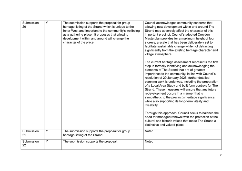
Whilst the recently gazetted Croydon TOD provisions seek to
increase density in The Strand due to the proximity to public transport, the
proposed local group heritage listing intends to strengthen character
protections and inform heritage planning processes for any future development
in The Strand, Croydon.
The Planning Proposal will
facilitate the group heritage listing of The Strand under Schedule 5 of BLEP
2012. The Strand is currently located in the Malvern Hill Conservation Area
under BLEP 2012 but not listed as a heritage item under Schedule 5.
The Planning Proposal is supported by an independent
heritage advice prepared by a qualified heritage consultant, GML in accordance
with the resolution of Council’s extraordinary meeting of 29 January
2025. The advice provided in the report by GML concludes that The Strand
demonstrates heritage significance for local group listing and meets the
threshold of local significance under multiple criteria set out in the NSW
Heritage Office Guidelines.
It is recommended that the Council support the Planning
Proposal for the group heritage listing of The Strand, Croydon and endorse it
for DPHI Gateway Determination.
Recommendation(s)
1. That Council approve and endorse the preparation and
submission to the NSW Department of Planning, Housing and Infrastructure of a
request for Gateway Determination for a Planning Proposal to amend the Burwood
Local Environmental Plan 2012 by updating Schedule 5 to include a group
heritage listing for The Strand, Croydon. The Planning Proposal applies to the
properties located at 1–50 The Strand, Croydon, as outlined in this
report.
2. That, subject to the issuing of a Gateway Determination by
DPHI, the Planning Proposal be publicly exhibited for a minimum period of 28
days, with community consultation undertaken and a public hearing held in
accordance with the Environmental Planning and Assessment Act 1979.
3. That the General Manager be delegated authority to make
minor modifications to correct any numerical, typographical, interpretative, or
formatting errors, if required.
4. That the results of the Gateway Determination, community
consultation and engagement process, and public hearing be reported back to
Council.
Attachments
1⇩
Attachment 1 - Planning Proposal for Group Heritage Listing
- The Strand
2⇩
Attachment 2 - GML Final Heritage Assessment Report, The
Strand Croydon, August 2025
3⇩
Attachment 3 - Draft Heritage Inventory Sheet - The Strand
4⇩
Attachment 4 - List of Submissions - The Strand
5⇩
Attachment 5 - BLPP Minutes - Group Heritage Listing The
Strand - October 2025
Item Number 11/26 - Attachment 1
Attachment 1 - Planning
Proposal for Group Heritage Listing - The Strand

Item Number 11/26 - Attachment 2
Attachment 2 - GML Final
Heritage Assessment Report, The Strand Croydon, August 2025


Item Number 11/26 - Attachment 3
Attachment 3 - Draft
Heritage Inventory Sheet - The Strand
Item Number 11/26 - Attachment 4
Attachment 4 - List of
Submissions - The Strand
Item Number 11/26 - Attachment 5
Attachment 5 - BLPP
Minutes - Group Heritage Listing The Strand - October 2025
Council Meeting 24 March 2026
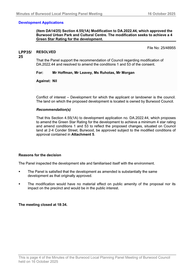
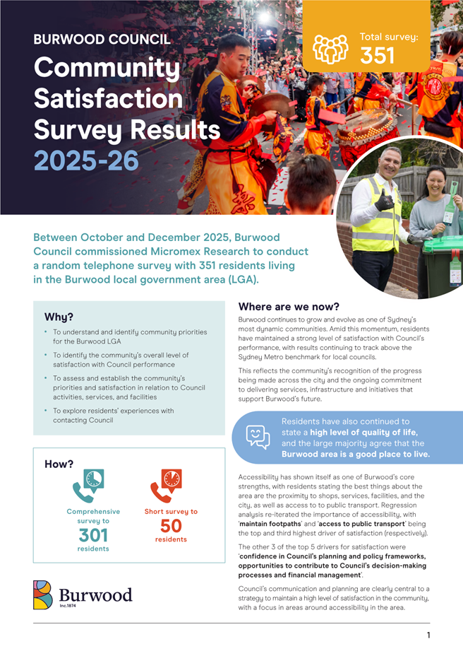
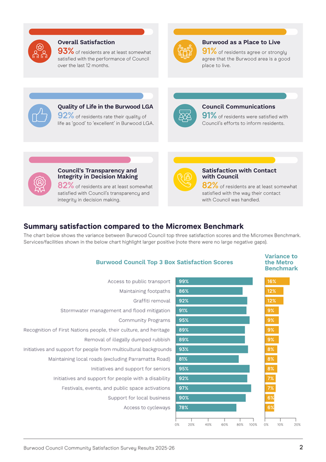
(Item 12/26) 2025-26 Burwood Community Satisfaction Survey
File No: 26/10324
Report by Director People & Performance
Summary
Every two years, Council
undertakes a community satisfaction survey to better understand
residents’ views, priorities and experiences. The most recent survey was
conducted by Micromex Research between October and November 2025.
The research involved a random
telephone survey of 351 residents living within the Burwood Local Government
Area, conducted via both landline and mobile phones.
This report presents the key
findings and insights from the survey, highlighting community priorities and
satisfaction levels.
Operational Plan Objective
C.11.1 Conduct Council business
with transparency, accountability, compliance and probity that ensures
community confidence in decision making
Background
The Community Satisfaction survey
assesses overall satisfaction with Council’s performance, identifies key
community priorities for Burwood’s future, measures satisfaction with a
range of Council services, facilities and activities, and explores
residents’ experiences when contacting Council.
The results provide a clear
snapshot of community perceptions and help guide Council’s strategic
focus over the coming years.
Proposal
Burwood continues to grow and
evolve as one of Sydney’s most dynamic communities. Amid this momentum,
residents have maintained a strong level of satisfaction with Council’s
performance, with results continuing to track above the Sydney Metro benchmark
for local councils.
This reflects the
community’s recognition of the progress being made across the city and
the ongoing commitment to delivering services, infrastructure and initiatives
that support Burwood’s future.
A summary of the survey results
is enclosed as an attachment.
Consultation
A comprehensive survey was
conducted with 301 residents, complemented by a shorter survey with an
additional 50 time‑poor residents.
Planning or Policy
Implications
No Planning or Policy
implications.
Financial Implications
No Financial implications.
Conclusion
As Burwood continues to welcome
new residents, understanding the community’s experience of the area
remains essential. This survey provides an important snapshot of how people
feel about living in Burwood and the role Council plays in supporting a vibrant,
well-serviced and connected community. Overall, the findings reflect a
community that remains positive about Council’s performance and the
direction of the area, with satisfaction levels continuing to sit above the
Sydney Metro benchmark.
Recommendation(s)
That
Council receive and note this report.
Attachments
1⇩
Community Satisfaction Survey Snapshot 2025-2026
Item Number 12/26 - Attachment 1
Community Satisfaction
Survey Snapshot 2025-2026
Council Meeting 24 March 2026
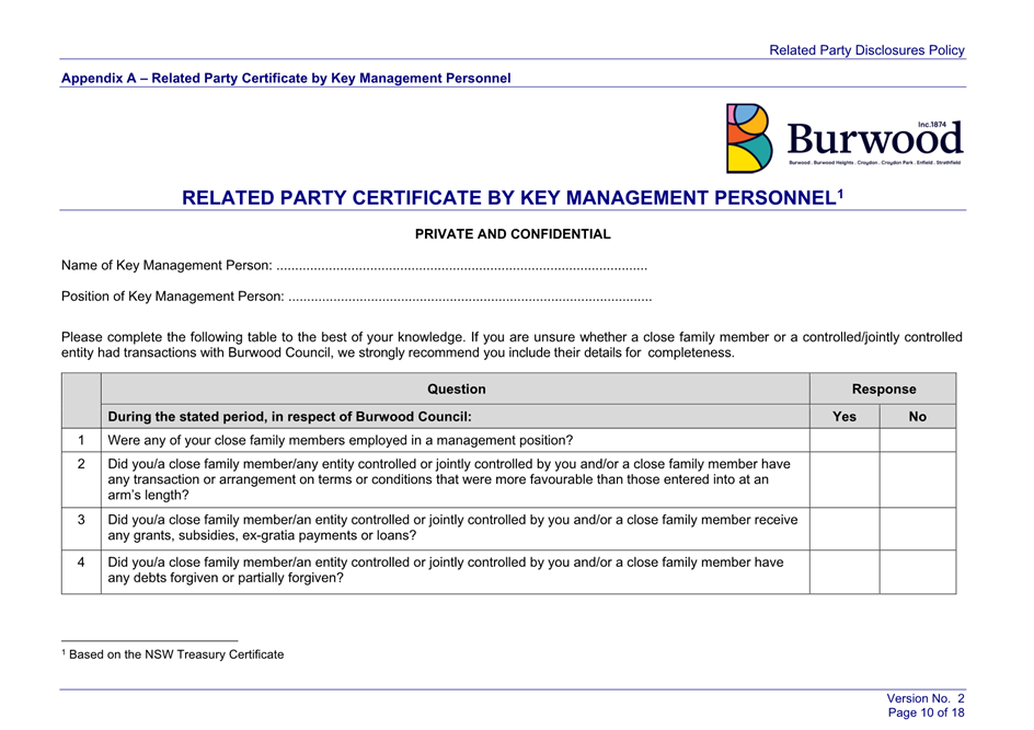
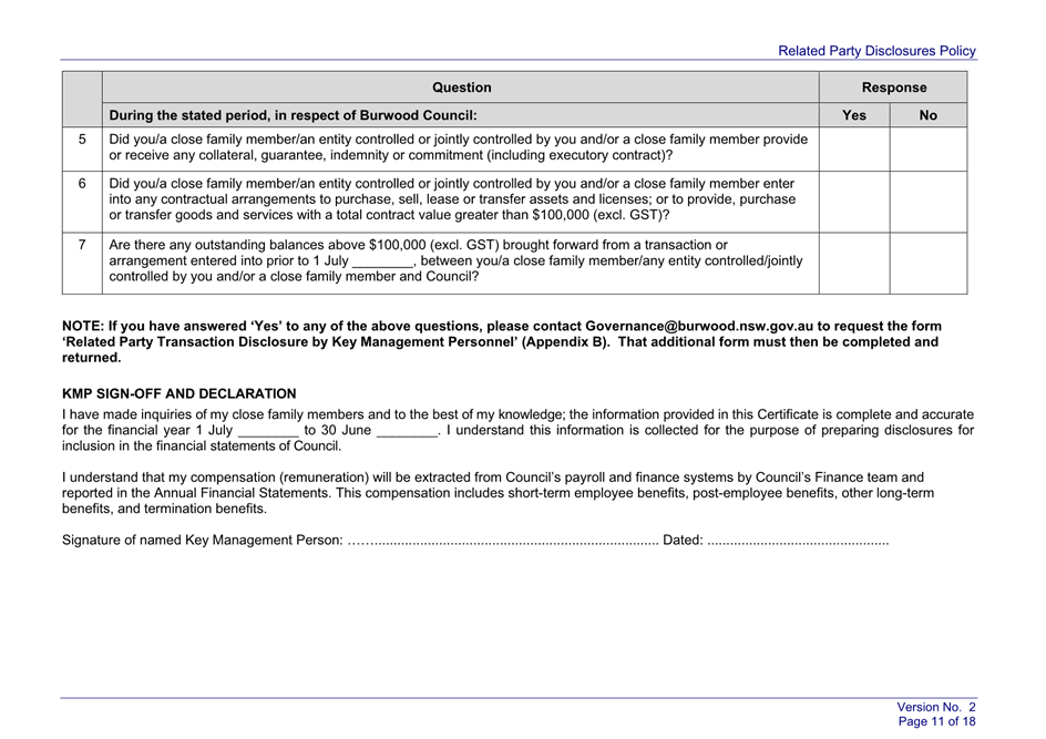
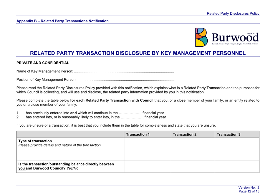
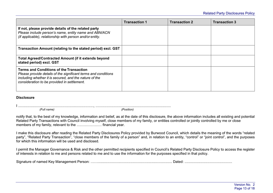
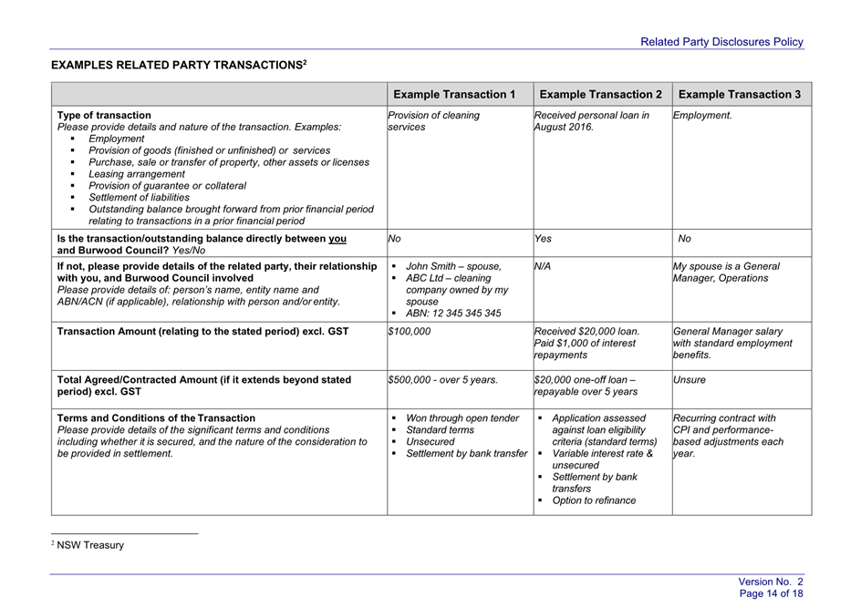
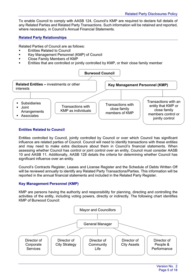
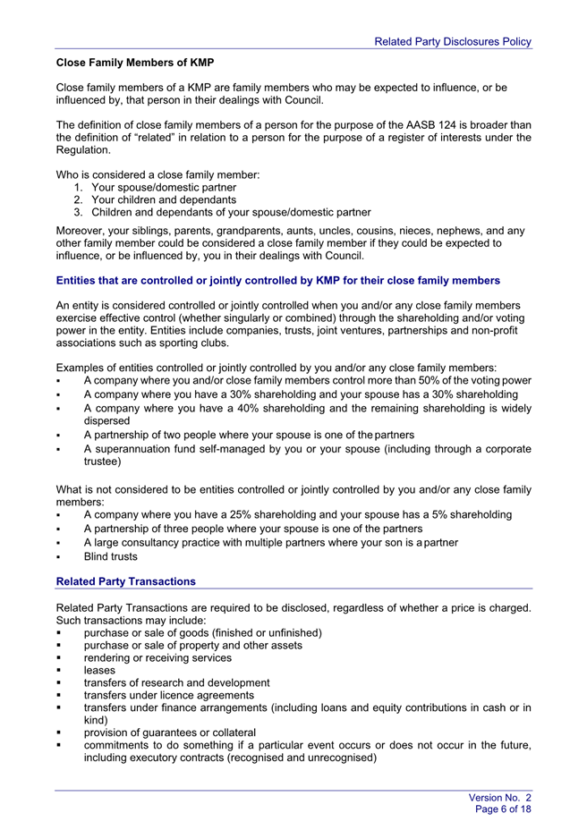
(Item 13/26) Draft Related Party Disclosures Policy - Endorsement for
Public Exhibition
File No: 26/10626
Report by Director Corporate Services
Summary
This report seeks Council
endorsement to place the updated draft Related Party Disclosures Policy
on public exhibition for subsequent adoption. The revised policy reflects
current legislative requirements in line with the Australian Accounting
Standards Board (AASB), and improves clarity regarding the obligations of
Councillors, Key Management Personnel of Council, and related persons. Public
exhibition will provide the community with an opportunity to review the updated
policy and offer feedback prior to adoption.
Operational Plan Objective
C11.1 Conduct Council business
with transparency, accountability, compliance and probity that ensures
community confidence in decision making
Background
Under the Australian Accounting
Standards, Council is required to disclose all related party relationships,
transactions, and Key Management Personnel compensations in its Annual
Financial Statements. The draft Policy sets out how Council identifies related
parties, captures and records related party transactions and commitments, and
discloses required information within annual financial statements in accordance
with AASB 124.
Proposal
The draft Related Party
Disclosures Policy, contained in Attachment 1 to this report, has
been prepared to ensure that Council’s financial statements contain the
necessary related party disclosures. This ensures public transparency in
dealings with Council and their effect on Council’s financial position.
The draft policy is based on the
current Related Party Disclosures Policy adopted in 2017 and has been
reviewed to ensure alignment with the current Australian Accounting Standards.
Despite no significant changes to the applicable Standards, the review
identified several areas where updates would improve readability and, therefore,
make it easier to comply with the Policy. The updated Policy clarifies
definitions and reporting responsibilities, whilst simplifying the process and
forms for managing disclosures.
Consultation
It is proposed to place this
draft Policy on public exhibition for 28 days and invite submissions from the
public. Placing the Policy on exhibition will ensure openness and provide the
community with the chance to comment on the proposed changes. If no submissions
are received, it is proposed that the Policy be automatically adopted without
further amendment. If submissions are received, a further report will be
brought back to Council.
Planning or Policy
Implications
No planning or additional policy
implications.
Financial Implications
No
financial implications.
Conclusion
The proposed revision of the Draft
Related Party Disclosures Policy is in line with current applicable
Australian Accounting Standards, effectively supporting transparency and
accountability within Council’s Annual Financial Statements.
Recommendation(s)
That Council:
1. places the Draft Related Party Disclosures
Policy, contained in Attachment 1 to this report, on public
exhibition for a period of 28 days and invite submissions from the public,
2. if submissions are received, directs the
General Manager to report on the outcome of public exhibition at the next
ordinary meeting of Council following the last date for the lodgement of
submissions, and
3. if no submissions are received, adopts the Draft
Related Party Disclosures Policy without further amendment and revokes the
previous Related Party Disclosures Policy adopted in 2017.
Attachments
1⇩
DRAFT - Related Party Disclosures Policy - Updated Version 2
Item Number 13/26 - Attachment 1
DRAFT - Related Party
Disclosures Policy - Updated Version 2
Council Meeting 24 March 2026
(Item 14/26) Draft Statement of Business Ethics - For Adoption
File No: 26/10627
Report by Director Corporate Services
Summary
It is proposed that Council
adopts an updated Statement of Business Ethics to guide suppliers on the
standards and expectations of suppliers when conducting business with Council.
Operational Plan Objective
C.11.1 Conduct Council
business with transparency, accountability, compliance and probity that ensures
community confidence in decision making
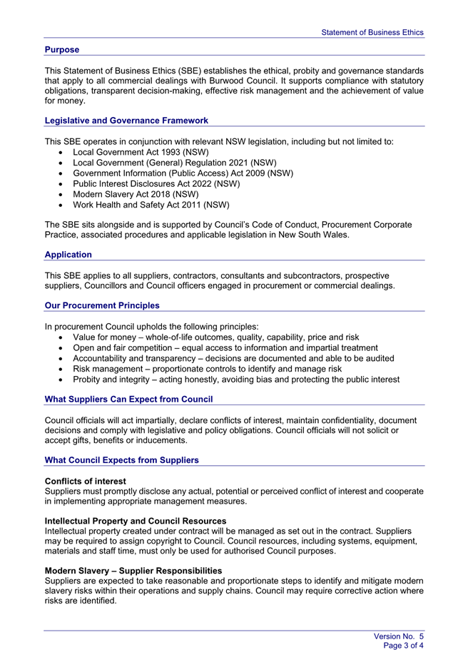
Background
The Statement of Business Ethics
sets out Burwood Council’s standards and expectations for ethical,
transparent and lawful business with our suppliers, contractors, consultants
and partners. Council has published a Statement of Business Ethics since 2007,
with the most recent Statement being thoroughly reviewed in 2018.
Proposal
The Statement has now been
reviewed and updated. The proposed Statement includes consideration of modern
slavery legislation, emerging cyber security and information management risks,
recommendations of ICAC investigations, and community expectations of social,
sustainable and ethical procurement practices.
The Statement will be published
on Council’s website alongside examples of prohibited or high-risk
conduct. Suppliers will be required to read and sign a supplier declaration
stating they have read and agree to the Statement of Business Ethics. Copies of
those documents are provided for information.
Consultation
The proposed Statement was
reviewed by the Audit Risk and Improvement Committee and that Committee’s
feedback was considered before finalising the draft Statement.
Planning or Policy Implications
While there is no legislative
requirement to have a Statement of Business Ethics, it is a long-standing
practice for most local councils as a probity and corruption-prevention
measure. The revised Statement is consistent with current legislation and with
existing procurement and governance practices in place at Council.
Financial Implications
No financial implications.
Conclusion
The proposed Statement reflects
legislative and procurement practice changes since the last review. Adoption of
the updated Statement will continue to support and encourage ethical
procurement practices for Burwood Council.
Recommendation(s)
That
Council:
1. places the Draft Statement of Business
Ethics contained in Attachment 1 to this report on public exhibition
for a period of 28 days and invite submissions from the public,
2. if submissions are received, directs the
General Manager to report on the outcome of public exhibition at the next
ordinary meeting of Council following the last date for the lodgement of
submissions, and
3. if no submissions are received, adopts the Draft
Statement of Business Ethics without further amendment and revokes the
Statement of Business Ethics last adopted in 2018.
Attachments
1⇩
Draft Statement of Business Ethics - Responsibility
Procurement v2
2⇩
Statement of Business Ethics - Examples of Prohibited or
High Risk Conduct
3⇩
Statement of Business Ethics - Supplier Declaration Template
Item Number 14/26 - Attachment 1
Draft Statement of
Business Ethics - Responsibility Procurement v2
Item Number 14/26 - Attachment 2
Statement of Business
Ethics - Examples of Prohibited or High Risk Conduct
Item Number 14/26 - Attachment 3
Statement of Business
Ethics - Supplier Declaration Template
Council Meeting 24 March 2026
(Item 15/26) Investment Report as at 31 January 2026 and 28 February 2026
File No: 26/10648
Report by Director Corporate Services
Summary
In accordance with Clause 212 of
the Local Government (General) Regulation 2005, this report details all
money that Council has invested under Section 625 of the Local Government
Act 1993.
Operational Plan Objective
A.103 Implement and monitor appropriate
investment strategies and prepare monthly investment reports.
Background
As provided for in Clause 212 of
the Local Government (General) Regulation 2005, a report listing
Council’s investments must be presented to Council.
Council’s investments are
made up of a number of direct investments, some of which are managed or advised
by external agencies.
Investment Portfolio
Council has a diversified
investment portfolio and has a number of direct investments in term
deposits. Its investment portfolio as at 31 January 2026 is:
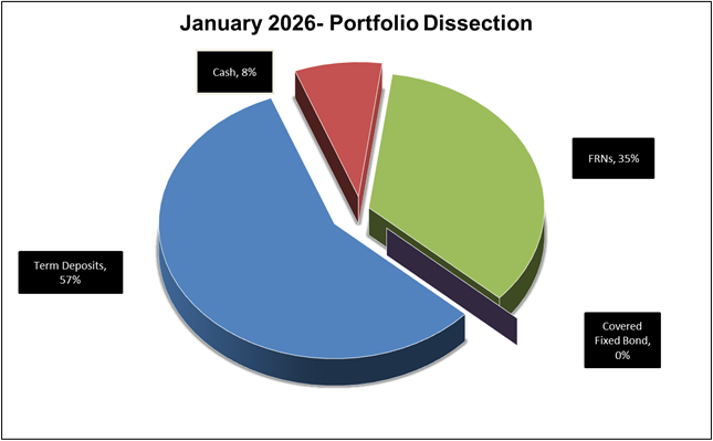
As at 31 January 2026 Council
held the following term deposits:
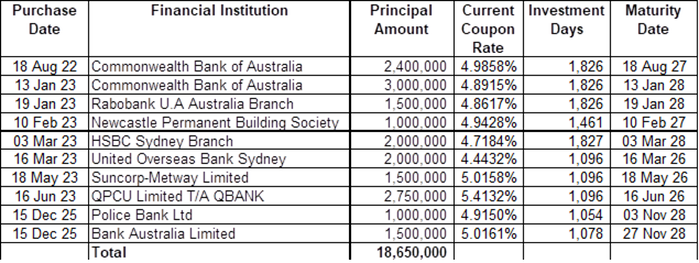
As at 31 January 2026 Council
held the following Floating Rate Notes:
Its investment portfolio as at 28
February 2026 is:
As at 28 February 2026 Council
held the following term deposits:
As at 28 February 2026 Council
held the following Floating Rate Notes:
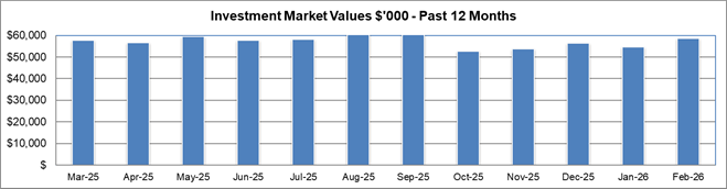
The following graph highlights
Council’s investment balances for the past 12 months:
Council’s investment
portfolio is recognised at market value and some of its investments are based
on the midpoint valuations of the underlying assets and are subject to market
conditions that occur over the month.
Council’s investment
balances as at reporting date are detailed in Attachment 1 & 2. Definitions
on the types of investments are detailed in Attachment 3.
Investment Performance and
Market Commentary
At the Reserve Bank of Australia
(RBA) meeting on the 3 February 2026, the Board decided to increase the
official cash rate by 25 basis points to 3.85 per cent. According to the
Statement by the Reserve Bank Board:
"…While
inflation has fallen substantially since its peak in 2022, it picked up
materially in the second half of 2025. The Board has been closely monitoring
the economy and judges that some of the increase in inflation reflects greater
capacity pressures. As a result, the Board considers that inflation is likely
to remain above target for some time.
Capacity
pressures reflect, in part, the greater momentum in demand seen in recent
months. Growth in private demand has strengthened substantially more than
expected, driven by both household spending and investment. Activity and prices
in the housing market are also continuing to pick up. Financial conditions
eased over 2025 and it is uncertain whether they remain restrictive. Credit is
readily available to both households and businesses and the effects of earlier
interest rate reductions are yet to flow through fully to aggregate demand,
prices and wages. More recently, the exchange rate, money market interest rates
and government bond yields have risen following a rise in market expectations
for the cash rate.
Various
indicators suggest that labour market conditions remain a little tight and that
they have stabilised in recent months, in line with the pick-up in momentum in
economic activity. The unemployment rate has been a little lower than expected
and measures of labour underutilisation remain at low rates. Growth in the Wage
Price Index has eased from its peak, but broader measures of wages growth
continue to be strong and growth in unit labour costs remains high.
There are
uncertainties about the outlook for domestic economic activity and inflation
and the extent to which monetary policy is restrictive. On the domestic side,
if growth in demand is stronger than expected, and growth in the
economy’s supply capacity remains limited, it is likely to add further to
capacity pressures. Uncertainty in the global economy remains significant but
so far there has been little or no depressing effect on the Australian economy;
indeed, recent growth and trade in Australia’s major trading partners has
surprised on the upside.
A wide range of
data over recent months have confirmed that inflationary pressures picked up
materially in the second half of 2025. While part of the pick-up in inflation
is assessed to reflect temporary factors, it is evident that private demand is
growing more quickly than expected, capacity pressures are greater than
previously assessed and labour market conditions are a little tight.
The Board
judged that inflation is likely to remain above target for some time and it was
appropriate to increase the cash rate target.
The Board will
be attentive to the data and the evolving assessment of the outlook and risks
to guide its decisions. In doing so, it will pay close attention to
developments in the global economy and financial markets, trends in domestic
demand, and the outlook for inflation and the labour market. The Board is
focused on its mandate to deliver price stability and full employment and will
do what it considers necessary to achieve that outcome.
Today’s
policy decision was unanimous.”
The following graph provides
information on the current RBA monetary policy:
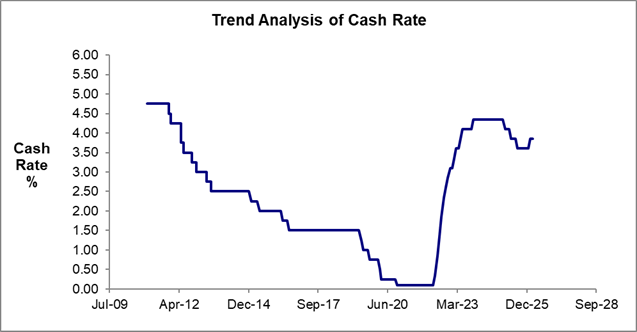
Recommendation(s)
1. That the investment report for 31 January
2026 and 28 February 2026 be received and endorsed.
2. That the Certificate of the Responsible
Accounting Officer be received and noted.
Attachments
1⇩
Investment Register January 2026
2⇩
Investment Register February 2026
3⇩
Investment Types
Item Number 15/26 - Attachment 1
Investment Register
January 2026
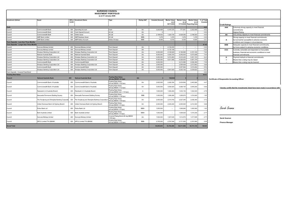
Item Number 15/26 - Attachment 2
Investment Register
February 2026
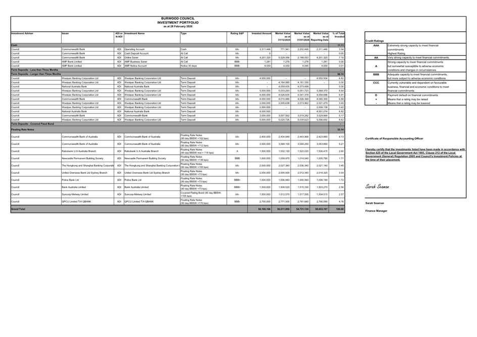
Item Number 15/26 - Attachment 3
Investment Types
Council Meeting 24 March 2026
(Item 16/26) National General Assembly of Local Government and the
Australasian Placemaking Summit 2026 - Conference Attendance
File No: 26/10831
Report by General Manager
Summary
This report is to inform Council
of the upcoming 2026 National General Assembly of Local Government and the 2026
Australian Placemaking Summit.
Operational Plan Objective
2.5.1 Provide strong leadership
and advocacy on behalf of the community.
Background
2026
National General Assembly of Local Government (NGA26)
The 2026
NGA26 will be held at the National Convention Centre in Canberra from 23 to 25
June 2026. Council may nominate one Voting Delegate, and Council is requested
to consider if and which Councillors will attend as delegate and nominated
observers.
The theme
for the NGA this year is “Stronger Together: Resilient. Productive.
United”.
2026
Australian Placemaking Summit
The
Australian Placemaking Summit will be held at the Sydney Masonic Centre, Sydney
from 13 to 14 May 2026. The Summit is a high-level forum for discussion
and debate around the crucial role of placemaking in creating
better places and shaping the future of cities and towns across Australia.
The 2-day summit will provide a leading platform for people from both the
government and private sectors to network and discuss opportunities as well as
solutions for challenges encountered in the process of placemaking. Council has
previously been invited to contribute to this national forum, helping to shape
national dialogue on placemaking.
Council may
nominate delegates to attend to gain a deeper understanding of the role of
placemaking within our community.
Financial Implications
NGA26
The table below indicates
approximate costs per person to attend the 2026 National General Assembly of
Local Government in Canberra:
|
· Early Bird
Registration Fee
(Payment due by Thursday 30
April 2026)
|
$999.00
|
|
· Conference
Dinners
o GA Dinner – Australian
War Memorial on Thursday 25 June 2026
|
$245.00
|
|
· Return Air Fare
to Canberra
Or Travel by Car
|
$550.00 - $600.00
|
|
· Hotel
Accommodation per Night
|
$495.00
|
Councillors
using private vehicles will be reimbursed in accordance with the Rate payable
for claims by Council Officers under the NSW (Local Government) State Award,
subject to the cost not exceeding the average air fare of other Councillors who
flew or, if no other Councillor flew, the Flexible Economy Class air fare to
the same destination available at the time of the conference.
Australian Placemaking
Summit
Below is an approximate cost
per person to attend the summit in Sydney:
|
· Early Bird
Registration Fee
|
$1,315
|
The above
expenses will be met by Council in accordance with the Councillors’
Expenses and Facilities Policy.
If
spouses/partners wish to accompany Councillors to the NGA26 or the Australian
Placemaking Summit, all costs, including any additional air fare/accommodation
costs, must be met by the Councillor or spouse/partner.
Recommendation(s)
1. That Council nominates the Mayor, or his
alternate, as the Voting Delegate for the 2026 National General Assembly of
Local Government (NGA26) to be held from 23 to 25 June 2026 in Canberra.
2. That Council determines the attendance of
Councillors and the General Manager as observers at the 2026 National General
Assembly of Local Government (NGA26) from 23 to 25 June 2026 in Canberra.
3. That Council determines the attendance of the
Mayor, Councillors and the General Manager as attendees at the 2026 Australian
Placemaking Summit from 13 to 14 May 2026 in Sydney.
Attachments
There are no attachments for this report.