Ordinary Meeting
Notice is hereby given that a
meeting of the Council of Burwood will be held in the Conference Room, 2 Conder
Street, Burwood on Tuesday 11 February 2025 at 6:00 PM to consider the matters
contained in the attached Agenda.
The public gallery will be open for
those wishing to observe the meeting. In addition, an opportunity to observe
the meeting via audio visual link will also be made available.
Public Forum
A public forum will be held at
6:00pm, prior to the commencement of the meeting, to allow members of the
public to make oral submissions about an item on the Agenda for the meeting.
The opportunity will also be provided to speak via audio visual link.
Anyone wishing to address Council
during the public forum will need to register by 2:00pm on the day of the
meeting. A person wishing to speak must indicate the item of business on the
Agenda they wish to speak on and whether they wish to speak ‘for’
or ‘against’ the item. Registrations to speak can be lodged on Council’s
website.
The Council Meeting will commence
immediately after the conclusion of the Public Forum.
Tommaso Briscese
General Manager
Agenda
For an Ordinary Meeting of Burwood Council to be
held in the Conference Room, Level 1, 2 Conder Street, Burwood on Tuesday
11 February 2025 immediately after the Public Forum commencing at 6.00pm.
1. Prayer
Lord, we humbly beseech thee to vouchsafe they blessing
on this Council, direct and prosper its deliberations for the advancement of
this area and the true welfare of its people. Amen.
2. Acknowledgement
of Country
3. Statement
of Ethical Obligations
4. Recording
of Meeting
5. Apologies
6. Declarations
of Interest
7. Declaration
of Political Donations
8. Confirmation
of Minutes
Minutes of the Council Meeting held on
Tuesday, 10 December 2024 and the Extraordinary Council Meeting held on
Wednesday, 29 January 2025, copies of which were previously circulated to all
councillors be hereby confirmed as a true and correct record.
9. Mayoral
Minutes
10. Reports to Council
(Item 2/25) Western
Sydney Infrastructure Grants Program – Quarterly Progress Report 5
(Item 3/25) Operational
Land Classification of certain Council Owned Land............ 13
(Item 4/25) Half-Yearly
Report - June to December 2024......................................... 36
(Item 5/25) Councillor
Expenses and Facilities Policy - Adoption............................. 40
(Item 6/25) Budget
Review for Quarter Ending 31 December 2024......................... 61
(Item 7/25) Investment
Report as at 30 November 2024 and 31 December 2024... 69
(Item 8/25) Amendment
of Council Meeting dates for 2025...................................... 78
11. Notices of Motion
(Item NM1/25) Australia
Day Citizenship Ceremony and Distrubution of Australian Flags 79
12. Confidential
Items
(Item MM1/25) General
Manager Contract Renewal
That above item
be considered in Closed Session to the exclusion of the press and public in
accordance with Section 10A(2) (a) of the Local Government Act, 1993, as the
matter involves personnel matters concerning particular individuals.
13. Conclusion
of the Meeting
Council
Meeting 11 February 2025
Reports to Council
(Item 2/25) Western Sydney
Infrastructure Grants Program – Quarterly Progress Report
File No: 24/49059
Report by General Manager
Summary
This report provides Council with
a high-level progress update on the delivery of the Western Sydney
Infrastructure Grants Program currently underway, and is the first in a series
of ongoing quarterly reports.
Operational Plan Objective
1.1.1 Provide a diverse range of strategies and
initiatives that meet the needs of the community
2.2.2 Strategic
partnerships that will benefit the area and community
3.1.2
Partnerships and opportunities to create new open spaces
4.2.1 Quality
local infrastructure that caters to population growth
5.1.1. A stimulated
local economy and activated Burwood CBD
Background
In 2022, the New South Wales
Government announced the Western Sydney Infrastructure Grants Program, formally
known as WestInvest. This program was established to support the delivery of
transformational infrastructure projects aimed at enhancing communities,
improving liveability, and driving economic recovery.
A total of $2 billion was made
available, with $400 million allocated between fifteen eligible Local
Government Areas based on population size. The remaining $1.6 billion was
distributed through a competitive community grant round open to councils and
other non-government organizations, including community groups,
not-for-profits, and Local Aboriginal Land Councils.
Burwood Council was successful in
securing over $110 million in funding to deliver 11 city-shaping projects over
the next four years, receiving the highest amount of funding per capita in the
community competitive round.
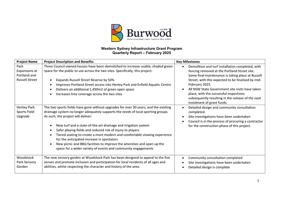
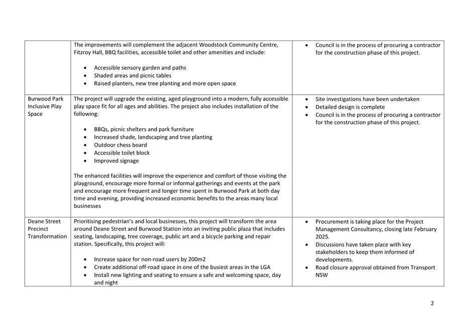
The 11 successful projects are:
1. Enfield
Aquatic Centre Redevelopment
2. Burwood Urban Park Arts and Cultural Centre
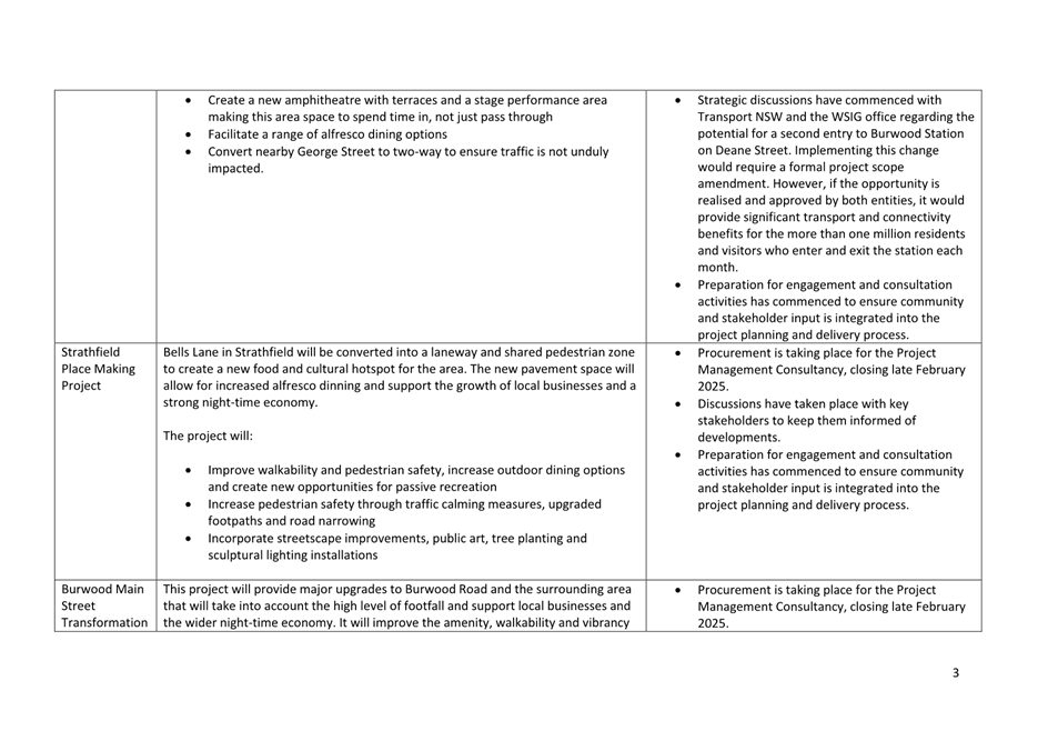
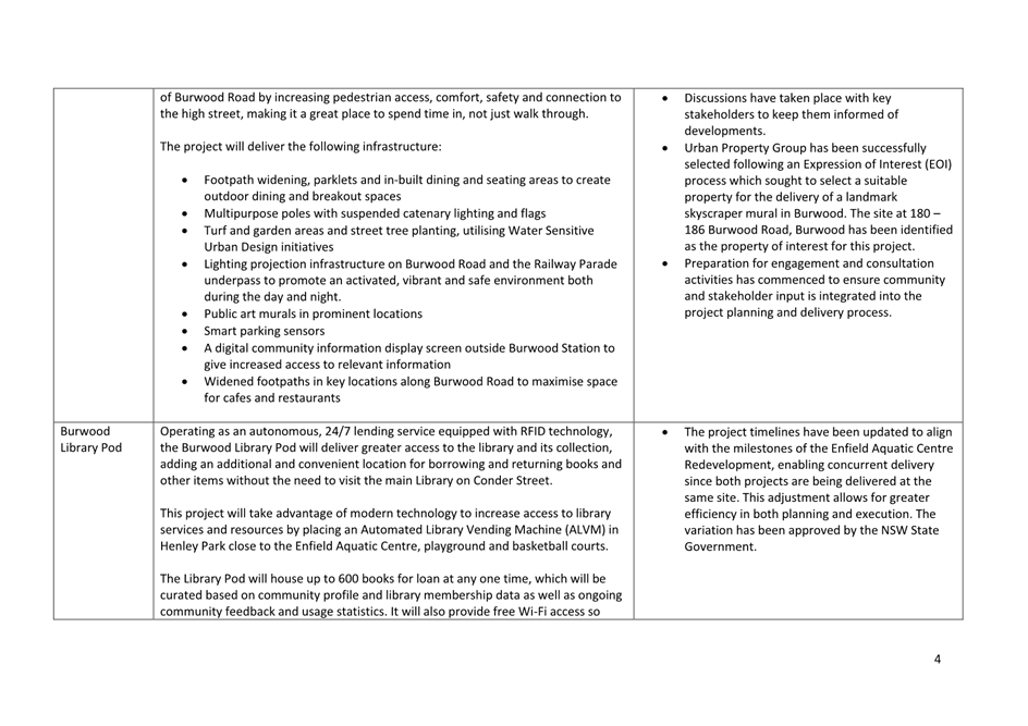
3. Burwood Main Street Transformation
4. Deane Street Precinct Transformation
5. Strathfield Placemaking Project
6. Paisley Road Beautification
7. Henley Park Sports Field Upgrade
8. Burwood Park Inclusive Play Space
9. Woodstock Park Sensory Garden
10. Burwood Library Pod
11. Park Expansions at Portland and Russell Street
Proposal
Following the delivery of a
number of preliminary briefings and updates on the preparation of applications
and the successful receipt of funding, Council committed to keeping Councillors
informed with regular updates on key project milestones for this program.
During this time, Council has also been in the process of executing deeds of
agreement with the State Government.
As such, this report is the first
in a series of quarterly updates that will be presented to Council, providing
information on key activities and deliverables.
Consultation
All projects have either
undergone or will undergo community consultation specific to their draft design
and delivery. This consultation will take various forms, including seeking
feedback through Council’s engagement platform, Participate Burwood,
engaging relevant stakeholders and hosting information sessions.
Ongoing monitoring and evaluation
reviews will continue, including post-project completion assessments. Regular
engagement with the Western Sydney Infrastructure Grants Program office will
also be maintained throughout this period, including fortnightly check-ins,
quarterly reporting, site visits for each project, and the submission of
multiple acquittals at agreed milestones.
Financial Implications
Eight of the eleven projects are
fully funded by the Western Sydney Infrastructure Grants program, while the
remaining three are primarily funded through the grant with additional
co-contributions from Council, which have already been budgeted.
These co-funded projects include
the Burwood Urban Park Arts and Cultural Centre, Enfield Aquatic Centre, and
Burwood Park Upgrade. All applications have been assessed by the Western Sydney
Infrastructure Grants office, and countersigned Deeds have been issued, with
milestone one funding received by Council.
As the projects and budgets were
originally developed over two years ago, cost escalation is a challenge faced
by all grant recipients. However, each project includes a budget allocation for
escalation and contingency to account for unforeseen developments.
Additionally, value engineering remains an option for any projects that
encounter financial constraints, though this is not expected to be a
significant issue in most cases. Any foreseeable risks associated with project
budgets are flagged with the State Government as part of Council’s
quarterly reporting to the Department of Premier and Cabinet.
Conclusion
The Western Sydney Infrastructure
Grants program represents a significant investment in Burwood’s future,
delivering eleven transformational projects that will enhance community
infrastructure, improve public spaces, and support economic growth.
With funding secured and project
planning well underway, Council remains committed to ensuring successful
delivery through ongoing monitoring, stakeholder engagement, and careful budget
management.
Regular updates will continue to
be provided to Councillors, ensuring transparency and accountability as these
projects progress. Through collaboration with the community and key
stakeholders, Burwood is well-positioned to maximise the benefits of this
program and create lasting positive impacts for residents, businesses, and
visitors alike.
Recommendation(s)
That Council notes the contents of this report, including
updates on the progress of the Western Sydney Infrastructure Grants program.
Attachments
1⇩
Western Sydney Infrastructure Grant Program - Key Milestones
- Quarterly Report - February 2025
Item Number 2/25 - Attachment 1
Western Sydney
Infrastructure Grant Program - Key Milestones - Quarterly Report - February
2025
Council
Meeting 11 February 2025
(Item 3/25) Operational Land
Classification of certain Council Owned Land
File No: 24/20102
Report by Director City Strategy
Summary
This report seeks Council’s
endorsement to commence a Planning Proposal process under the Environmental
Planning and Assessment Act 1979 to update the provisions of Burwood Local
Environmental Plan 2012 (BLEP), to include additional permitted uses and accurately
reclassify and list certain Council-owned public land from Community Land to
Operational Land under the Local Government Act 1993 (LG Act). This update
will not alter the current use or operational practice of each site but rectify
any historical anomalies in land use and land classifications.
Operational Plan Objective
A.102 Comply with
financial management responsibilities to promote transparency and accountability.
A.104 Manage
Council’s property portfolio to optimise financial returns from Council-owned
properties.
C.5 Public
and open spaces are high quality, welcoming, accessible, shaded, enjoyable places
seamlessly connected with their surroundings
C.9 Safe,
clean and activated streets, centres and public places are enjoyed by people
day and night
C.10 A
well-informed community active in civic life, local planning and decision
making
C.11 Effective,
innovative and collaborative leadership is underpinned by open, transparent and
responsible governance
Background
Under the Local Government Act
1993 (LG Act), all Council-owned public land must be classified as either Community
Land or Operational Land, which determines how the land is to be managed.
Community Land is intended for public
use, such as parks, reserves, sportsgrounds, and bushland. It cannot be sold
and requires a Plan of Management. Leases over 21 years need Ministerial
consent. Some land must remain public and community land due to legal
obligations like trust deeds or previous dedications.
Operational Land is used for Council
functions such as offices, depots, car parks, or commercial investments. It may
also be held as a temporary asset and can be developed, leased, or sold as
needed.
Public land is classified through
either an LEP or Council resolution. If land remains unclassified for three
months after acquisition, it defaults to Community Land.
Land classification distinguishes
public-use land from land that can be managed more freely. To change a
Community Land classification, Council must amend the Burwood Local
Environmental Plan 2012 (BLEP), including public exhibition and a hearing.
In compliance with Ministerial
Directions for Local Planning Panels, the proposal was reviewed by the Burwood
Local Planning Panel in November 2024 in order to provide advice as necessary
to the Council.
Proposal
This
report proposes updating the Burwood Local Environmental Plan 2012 (BLEP)
through a Planning Proposal under the Environmental Planning and Assessment Act
1979 (EPA Act) to accurately reclassify certain Council-owned public land from
Community Land to Operational Land under the Local Government Act 1993 (LG Act)
in addition to updating land use permissibility.
The reclassification will be
carried out by amending the BLEP through the local plan-making process under
the EPA Act while ensuring compliance with the LG Act's public land management
requirements.
The Planning
Proposal is proposed to include:
A. Reclassification
of Items 1-16, 18-27, 29 & 31 below as ‘Operational Land’ under
the LG Act and list these sites under Schedule 4; Part 1 of BLEP as Land
classified, or reclassified, as operational land – no interests changed.
B. Reclassification
of Items 17, 28 & 30 below as ‘Operational Land’ under the LG
Act and list these sites under Schedule 4; Part 1 of BLEP for the purposes of
subdividing the land.
Once the
land is subdivided, the community land part of the site will return to a
classification of Community via a separate report to Council, and the
Operational part of the site will continue to be classified as Operational. The
relevant items are identified as follows:
· Item
17, Unity Place;
· Item
28, 39 Minna Street and Jackson Reserve; and
· Item
30, Woodstock Park.
C. Inclusion
of additional Permitted Uses of Items 3, 6, 13, 18 & 26 under the Planning
Proposal to amend Schedule 1, Additional Permitted Uses, of the Burwood LEP, as
the use of the land for its current use and purpose is not permitted under the
current zone of the land. The relevant items are identified as follows:
· Item
3, Beresford Car Park, 50 Beresford Avenue, Croydon Park to include an
additional permitted ‘car park’ land use;
· Item
6, Council Depot, 8 Kingsbury Street, Croydon Park to include an additional
permitted ‘depot’ land use;
· Item
13, Fitzroy Street Car Park, 1a Fitzroy Street, Burwood to include an
additional permitted ‘car park’ land use;
· Item
18, Meryla Street Car Park, 33-35 Meryla Street, Burwood to include an
additional permitted ‘car park’ land use; and
· Item
26, 41 Brighton Street, Croydon to include an additional permitted
‘dwelling’ land use.
This update will not alter current use or
operational practice but rectify any historical anomalies in land
classifications under Council’s Environmental Planning Instrument.
Items Details
Details of each site
proposed to be classified as “Operational” is provided below.
|
Item 1
|
Angelo Street
Car Park
|
|
Address
|
133
Liverpool Road, Burwood
|
|
|
Title
|
Lot
1 DP 1135151
|
|
Zoning
|
Local
Centre E1
|
|
Land
Use
|
Car
Park
|
|
Description
|
133
Liverpool Road is a carpark to the side of Angelo Street with access to the
bays directly off Angelo Street.
As
the carpark is in operational use it is appropriate to classify it as
operational land.
|
|
The
land was acquired by Council in 1970 and has been used as a car park ever
since. The car park has a 2-hour daytime parking restriction and no fee is
charged for its use.
The
land is not leased and is not a public reserve.
There
are no development approval records available, however the use of land as a
car park is permitted with consent in the E1 zone. It has been used as a car
park since prior to the Burwood LEP commencing in 2012.
|
|
Item 2
|
Land adjoining rear of 10 Luke Avenue
|
|
Address
|
Portion
adjoining rear of 10 Luke Avenue
|
|
|
Title
|
N/A
|
|
Zoning
|
Road
reserve
|
|
Land
Use
|
Car
Park
|
|
Description
|
Part
of road reserve on Bennett Street, adjoining rear of Lot 13 in DP 1215985.
This
end of Bennett Street appears as a road reserve connecting to Parramatta
Road.
|
|
The portion of land
adjoining the eastern boundary of 10 Luke Avenue is believed to have been
acquired by Council in the past for the purpose of establishing a right of
way or easement. While specific acquisition details are not available in
current records, the land's configuration and use are consistent with
Council's historical practices of securing access and connectivity within the
local area. It is likely that Council acquired this land through standard local
government acquisition processes, potentially including purchase,
subdivision, or dedication, with the intent of facilitating public access or
utilities.
The exact date and
method of acquisition are uncertain due to incomplete historical records.
However, Council has exercised ownership and management responsibilities over
this land for an extended period, as evidenced by its continued use as a
public right of way/easement.
No development
approval records are available for this land parcel, which is consistent with
its apparent purpose as a right of way or easement.
|
|
Item 3
|
Beresford Car Park
|
|
Address
|
50
Beresford Avenue, Croydon Park
|
|
|
Title
|
Lot
1 DP 624841
|
|
Zoning
|
Low
Density Residential R2
|
|
Land
Use
|
Car
Park
|
|
Description
|
50
Beresford Avenue is a small carpark of approx. 13 bays accessed off the
laneway that runs parallel to Georges River Road.
As
the carpark is in operational use it is appropriate to classify it as
operational land.
|
|
The
land appears to have been acquired by Council in 1979 and has been used as a
car park ever since. The car park has a 2-hour daytime parking restriction
and no fee is charged for its use. The land is not leased and is not a public
reserve.
There
are no development approval records available. A car park is a prohibited
land use in the R2 zone and it is proposed to include the land in Schedule 1
of the LEP, Additional Permitted Uses. It has been used as a car park since
before the Burwood LEP commenced in 2012.
|
|
Item 4
|
Byer Street Car Park
|
|
Address
|
3B-5
Byer St, Enfield
|
|
|
Title
|
Lot
12 DP 11302, Lots 1-2 DP 305673
|
|
Zoning
|
Local
Centre E1
|
|
Land
Use
|
Car
Park
|
|
Description
|
The
Byer Street Car Park is a triangular shaped car park accessed off Byer
Street.
As
the carpark is in operational use it is appropriate to classify it as
operational land.
|
|
The
land was acquired by Council in 1975 and has been used as a car park ever
since. The car park has a 2-hour daytime parking restriction and no fee is
charged for its use. The land is not leased and is not a public reserve.
There
are no development approval records available, however the use of land as a
car park is permitted with consent in the E1 zone. It has been used as a car
park since before the Burwood LEP commenced in 2012.
|
|
Item 5
|
Land at 34 Cobden Street
|
|
Address
|
34
Cobden Street, Enfield
|
|
|
Title
|
Lot
5 DP 554097
|
|
Zoning
|
Low
Density Residential R2
|
|
Land
Use
|
Road
and Park
|
|
Description
|
The
land at 34 Cobden Street, Enfield, is partially used for a road and partially
as a small pocket park.
The
main use of the land is for road transport which is an operational use. As
such it is appropriate to classify it as operational land.
|
|
The
land was acquired by Council in 1971 and has been used as a road and park
ever since. The land is not leased and is not a public reserve.
The
use of land as for ‘road’ is permitted without consent and a
‘Park’ is permitted with consent in the R2 zone. It has been used
for these purposes since before the Burwood LEP commenced in 2012.
|
|
Item 6
|
Council Operations Centre (Depot)
|
|
Address
|
8
Kingsbury Street, Croydon Park
|
|
|
Title
|
Lot
1 DP 228032
|
|
Zoning
|
General
Residential R1
|
|
Land
Use
|
Depot
|
|
Description
|
The
land at 8 Kingsbury Street, Croydon Park is used as Council’s
Operations Centre (Council Depot).
As
the Depot is in operational use it is appropriate to classify it as
operational land.
|
|
Council records
indicate that this parcel of land, which serves as a Council depot, was
acquired in 1965 to support Council operations. The presence of a mortgagee
on the Certificate of Title suggests that the acquisition likely involved a
purchase, possibly financed through a mortgage.
While the exact
details of the transaction are not fully available in Council's current
records, the acquisition of this depot aligns with the period of expansion in
local government services and infrastructure in the mid-1960s. The decision
to acquire this property demonstrates Council's forward-thinking approach to
establishing necessary facilities for its growing operational needs.
Since its acquisition
in 1965, Council has maintained continuous ownership and use of this land for
nearly six decades, utilising it as a crucial depot to support various
Council functions and services. This depot has played a vital role in
Council's ability to efficiently manage its operations and deliver services
to the community.
The long-term use of
this property as a Council depot underscores its importance in Council's
operational infrastructure and highlights Council's commitment to maintaining
essential facilities for effective local governance.
The
land is not leased and is not a public reserve.
There are no development approval
records available. A Depot is a prohibited land use in the R1 zone and it is
proposed to include the land in Schedule 1 of the LEP, Additional Permitted
Uses. It has been used as a depot since before the Burwood LEP commenced in
2012.
|
|
Item 7
|
Burleigh Street Dwellings
|
|
Address
|
6,
12, 14, 16, 18, 20, 22 Burleigh Street, Burwood
|
|
|
Title
|
Lot
1 DP 205162,
Lots
1 – 6 DP 202437
|
|
Zoning
|
Mixed
Use MU1
|
|
Land
Use
|
Single
Dwellings
|
|
Description
|
6
and 12-22 Burleigh Street are seven terrace houses used for residential
purposes.
12-22
Burleigh Street is a heritage item in the LEP as Victorian Terraces.
|
|
The
properties located at 6, 12, 14, 16, 18, 20, and 22 Burleigh Street, Burwood,
comprising Lot 1 DP 205162 and Lots 1 - 6 DP 202437, were acquired by Council
at various times as part of its long-term strategic vision for the area.
These terraced properties were individually purchased over a period of time,
reflecting Council's forward-thinking approach to land assembly for future
community needs.
The
acquisitions of these properties occurred progressively between 1976 –
2023.
The
strategic nature of these purchases indicates a deliberate and planned
approach by Council to secure key sites within the Burwood area.
The properties were
acquired through direct purchases from private owners, aligning with
Council's practice of strategically obtaining land to support future
community development and urban planning objectives. This approach allowed
Council to gradually assemble a significant land holding in a key location,
providing flexibility for future use and development in line with evolving
community needs.
Currently,
only three of these terraces remain leased due to the dilapidated state of
the buildings. The remaining properties require significant capital
investment to remediate their condition, making them unsuitable for use. As a
result, Council proposes to reclassify these properties as operational land.
This reclassification will enable Council to develop a long-term masterplan
for the entire precinct, allowing for a comprehensive approach to
revitalisation and future development that aligns with Council's strategic
vision.
The
proposed reclassification to operational land will provide Council with the
necessary flexibility to address the significant remediation needs of these
properties and to explore various options for their future use. This approach
will ensure that these valuable assets can be effectively utilised to meet
the evolving needs of the Burwood community.
Council's decision to seek
reclassification demonstrates its commitment to responsible asset management
and its dedication to realising the long-term strategic vision for this
important precinct in Burwood. As the premises are and intend to be an
operational use it is appropriate to classify it as operational land.
|
|
Item 8
|
Elizabeth Street Car Park
|
|
Address
|
5-11
Elizabeth Street, 18B Railway Parade and 8-10 Burleigh Street, Burwood
|
|
|
Title
|
Lot
1 DP 574391
Lot
2 DP 205162
Lots
A & B DP420885
Lot
3 DP 511953
Lots
A & B DP321515
Lot
1 DP 305065
|
|
Zoning
|
Mixed
Use MU1
|
|
Land
Use
|
Car
Park
|
|
Description
|
The
Elizabeth Street Car Park is a town centre car park located behind buildings
fronting Railway Parade and accessed off Burleigh and Elizabeth Streets
As
the carpark is in operational use it is appropriate to classify it as
operational land.
|
|
The
properties located at 5-11 Elizabeth Street and 8-10 Burleigh Street, were
acquired by Council at various times as part of its long-term strategic
vision for the area. These properties were individually purchased over a
period of time, reflecting Council's forward-thinking approach to land
assembly for future community needs.
The
acquisitions of these properties occurred progressively between 1976 –
2023.
The
strategic nature of these purchases indicates a deliberate and planned
approach by Council to secure key sites within the Burwood area.
The
properties were acquired through direct purchases from private owners,
aligning with Council's practice of strategically obtaining land to support
future community development and urban planning objectives. This approach
allowed Council to gradually assemble a significant land holding in a key
location, providing flexibility for future use and development in line with
evolving community needs.
Council's
decision to seek reclassification demonstrates its commitment to responsible
asset management and its dedication to realising the long-term strategic vision
for this important precinct in Burwood.
The
land is not leased and is not a public reserve. There are no development
approval records available, however the use of land as a car park is
permitted with consent in the MU1 zone. It has been used as a car park since
before the Burwood LEP commenced in 2012.
|
|
Item 9
|
Elsie Street Shops
|
|
Address
|
Shops
C1a, C1b, C2 and C3 Elsie Street, Burwood
|
|
|
Title
|
Lot
11 DP 1142160
|
|
Zoning
|
Mixed
Use MU1
|
|
Land
Use
|
Shops
|
|
Description
|
These
sites are ground floor shops leased to tenants.
As
the shops are in operational use it is appropriate to classify them as
operational land.
|
|
The
land was acquired by Council in 2009 and has been used for shops and offices
since the building was constructed in 2009 (DA379/2001).
The
shops are leased to tenants on standard commercial leases, and is not a
public reserve.
Consent
for the development was issued in 2001, however the use of land as a shop is
permitted with consent in the MU1 zone.
|
|
Item 10
|
Elsie Street Lot 15
|
|
Address
|
Elsie
Street Suite1 Level 2, part Level B3, Shop C9 & loading dock car spaces
|

|
|
Title
|
Lot
15 DP 1177555
|
|
Zoning
|
Mixed
Use MU1
|
|
Land
Use
|
Office,
Shop, Car Park
|
|
Description
|
These
sites are shops, offices leased to tenants, and a loading dock with two car
spaces
As
the uses are operational uses it is appropriate to classify them as
operational land.
|
|
The
land was acquired by Council in 2009 and has been used for shops and offices
since the building was constructed in 2009 (DA379/2001).
The
shops are leased to tenants on standard commercial leases, and is not a
public reserve.
Consent
for the development was issued in 2001, however the use of land as a shop is
permitted with consent in the MU1 zone.
|
|
Item 11
|
George Street Car Park
|
|
Address
|
1-17
Elsie St, Burwood
|

|
|
Title
|
Lot
13 DP 1142160
|
|
Zoning
|
Mixed
Use MU1
|
|
Land
Use
|
Car
Park
|
|
Description
|
The
George Street Car Park is a town centre car park located in the basement of
1-17 Elsie Street, accessed off George Street.
As
the carpark is an operational use it is appropriate to classify it as
operational land.
|
|
The
land was acquired by Council in 2009 and has been used as a car park since
the building was constructed in 2009 (DA379/2001). The land is not leased and
is not a public reserve.
Consent
for the development was issued in 2001, however the use of land as a car park
is permitted with consent in the MU1 zone.
|
|
Item 12
|
Elsie Street Loading Dock and George Street Community
Centre
|
|
Address
|
1-17
Elsie St, Burwood
|
|
|
Title
|
Lot
33 SP 93494
|
|
Zoning
|
Mixed
Use MU1
|
|
Land
Use
|
Car
Park
|
|
Description
|
The
Elsie Street Loading Dock and associated Car Park is located in the basement
of 1-17 Elsie Street, accessed off George Street.
As
the loading dock and carpark is an operational use it is appropriate to
classify it as operational land.
|
|
The
land was acquired by Council in 2009 and has been used as a car park since
the building was constructed in 2009 (DA379/2001). The land is not leased and
is not a public reserve.
Consent
for the development was issued in 2001, however the use of land as a car park
and a community centre is permitted with consent in the MU1 zone.
|
|
Item 13
|
Fitzroy Street Car Park
|
|
Address
|
1a
Fitzroy St, Burwood (adjacent to Reed Reserve).
|
|
|
Title
|
Lots
1 and 2 DP 8973
|
|
Zoning
|
Low
Density Residential (R2)
|
|
Land
Use
|
Car
Park
|
|
Description
|
These
lots form part of the Fitzroy Street Car Park in Croydon Town Centre.
As
the carpark is an operational use it is appropriate to classify it as
operational land.
|
|
The
Fitzroy Street Car Park was acquired by Council in the 1970s as part of a
strategic initiative to provide public parking facilities in the area. While
specific development approval records are not available, the site has been
continuously used as a car park since acquisition, and has a 2-hour daytime
parking restriction and no fee is charged for its use. This long-standing use
predates the current Burwood Local Environmental Plan 2012 and is consistent
with the site's current zoning. The land is not leased and is not a public
reserve.
|
|
Item 14
|
462a Georges River Road
|
|
Address
|
462A
(Rear) Georges River Rd, Croydon Park
|
|
|
Title
|
Lot
2 in DP 1125122
|
|
Zoning
|
General
Residential (R1)
|
|
Land
Use
|
Municipal
Purposes
|
|
Description
|
The
land behind the childcare centre is currently used for Council operational
purposes (Storage)
As
the storage is an operational use it is appropriate to classify the site as
operational land.
|
|
The
property at 462a Georges River Road, Croydon Park, is currently utilised for Council
operational purposes. Historical records and the Certificate of Title suggest
that this parcel was originally part of a larger land holding at 462 Georges
River Road.
It
appears that Council subdivided the original property, selling off the front portion
which has since been redeveloped into a day care facility. The retained rear
portion, now known as 462a Georges River Road, was kept for Council use and
is bound by various easements and rights of way, likely established during
the subdivision process to ensure access and utilities for both the sold and
retained portions of land.
While
the exact date of the subdivision and partial sale is unknown, this strategic
land management decision by Council demonstrates its ability to balance
community needs with operational requirements. By retaining a portion of the
original property for Council operations while allowing development on
another portion, Council has efficiently utilised its land assets.
The
current use of 462a Georges River Road for Council operational purposes
underscores its ongoing importance to Council's service delivery
capabilities. The easements and rights of way associated with the property
reflect the complex nature of urban land use and the need for careful
planning in land subdivision and repurposing.
Council
has maintained ownership and management of this operational land since the
subdivision, adapting its use to meet evolving Council needs while ensuring
continued access and functionality through the established easements and rights
of way.
|
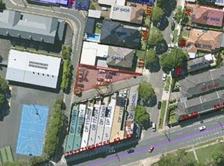
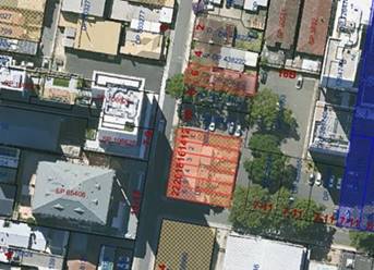
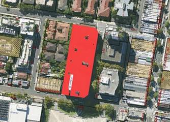
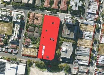
Item 15
|
45 Heydon Street
|
|
Address
|
45
Heydon St, Enfield
|
|
|
Title
|
Lot
121 DP 456968 and Lot 120 DP 456968
|
|
Zoning
|
Low
Density Residential (R2)
|
|
Land
Use
|
Road
and Footpath
|
|
Description
|
The
land at 45 Heydon Street, Enfield is used for road purposes.
The
main use of the land is for road transport which is an operational use it is
appropriate to classify it as operational land.
|
|
Acquired
by Council in 1974, this land has been consistently utilised as part of the
local road network. Its use as a road is permissible without consent under
the current R2 zoning, reflecting its ongoing importance in local traffic
management and connectivity.
The
land is not leased and is not a public reserve. It has been used for these
purposes since before the Burwood LEP commenced in 2012.
|
|
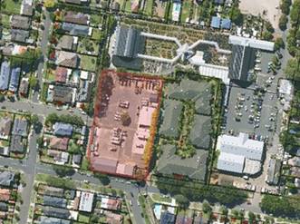
Item 16
|
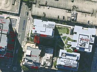
Council Chambers, Customer Service & Library
|
|
Address
|
2-4
Conder St, Burwood
|
|
|
Title
|
Lot
1 DP 1252835
|
|
Zoning
|
Mixed
Use MU1
|
|
Land
Use
|
Office,
Shop, Library, Community Facility
|
|
Description
|
These
community and office uses within the Council Administration Centre.
As
shops and offices an operational uses it is appropriate to classify them as
operational land.
|
|
2-4
Conder Street, Burwood (Lot 1 DP 1252835) encompasses the original Council
Chambers, a heritage-listed building that still accommodates the Mayor,
Councillors, and some administrative staff. This significant site has evolved
to meet changing community needs, with a modern extension to the rear housing
Council's customer service center, library, and various community facilities.
In 2020, the site underwent substantial upgrades, further enhancing its
functionality and amenities.
The
property serves multiple operational functions, including civic
administration, community services, and public amenities. A licensed coffee
cart operates on the premises, enhancing visitor amenities. Additionally, the
site includes a paid public car park that supports access to these essential
community facilities.
Council
actively manages this multi-faceted property to maintain its heritage values
while ensuring it continues to meet contemporary operational and community
service needs. The 2020 upgrades demonstrate Council's commitment to ongoing
improvement and adaptation of the site. Regular maintenance, service assessments,
and strategic planning are undertaken to optimise the site's diverse uses and
preserve its importance as a civic and community hub. Furthermore, Council is
in the process of delivering an art and cultural centre with underground
parking within the current carpark location. This development will
significantly enhance the precinct and community amenity. Classifying the
land as operational will provide Council with the necessary flexibility to
further activate and enhance the site, ensuring it continues to evolve and
meet the dynamic needs of the Burwood community.
|
|
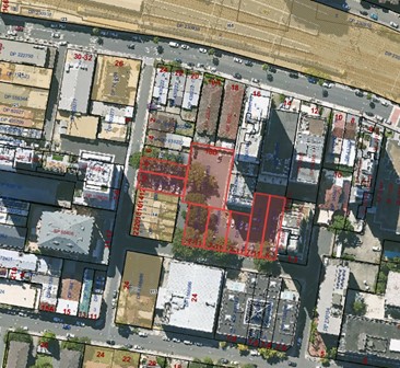
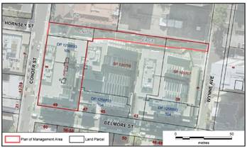
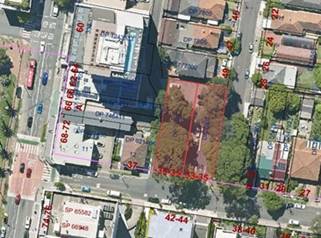
Item 17
|
Unity Place (Part)
|
|
Address
|
Hornsey
St, Burwood
|
|
|
Title
|
Lot
105 DP1258893
|
|
Zoning
|
Mixed
Use MU1
|
|
Land
Use
|
Council
administration, retail and commercial, civic domain, community facility
|
|
Description
|
These
community and office uses within the Council Administration Centre.
As
shops and offices an operational uses it is appropriate to classify them as
operational land.
|
|
Formerly
known as Hornsey Street, this area was renamed Unity Place in 2021. The site
is subject to a specific Plan of Management which outlines its intended
future reclassification to operational land, supporting Council's long-term
strategic planning for the precinct
The Conder Street and (formerly) Hornsey
Street, Burwood location, now known as Unity Place is widely considered the
historic and ‘spiritual’ home of Burwood Council and recognised
as the hub of community related activities.
Unity Place has allowed Council to achieve
its identified strategic objectives through the creation of a modern and
industry leading Civic Centre capable of simultaneously hosting
Council’s administration, library, community and customer service
functions at 2 and 8 Conder Street, Burwood. The co-location of various
services in a modern, easily accessible and well connected facility has
generated multiple synergies and opened up innumerable opportunities to
increase service levels and activate adjoining public spaces.
The spaces within
Lot 105 in DP1258893 of the 39-47 Belmore Street, 6-14 Conder Street
and Wynne Avenue, Burwood site, is now addressed as 8 Conder Street and
49 Belmore Street, Burwood and known in its entirety as Unity Place (formerly
Hornsey Street, Burwood).
|
|
Item 18
|
Meryla Street Car Park
|
|
Address
|
33-35
Meryla St, Burwood
|
|
|
Title
|
Lots
58 & 57 DP 7805
|
|
Zoning
|
Low
Density Residential (R2)
|
|
Land
Use
|
Car
Park
|
|
Description
|
33-35
Meryla Street is a small town centre carpark.
As
the carpark is an operational use it is appropriate to classify it as
operational land.
|
|
The
Meryla Street Car Park has been a long-standing public parking facility in
the area, since its acquisition in 1977. Its continuous use as a car park
predates the current LEP. The proposed inclusion in Schedule 1 of the LEP
will formalise its permissibility in the R2 zone, reflecting its established
and ongoing use. The land is not leased and is not a public reserve.
There
are no development approval records available.
|
|
Item 19
|
Murphys Lane
|
|
Address
|
17a
Wright St, Croydon
|
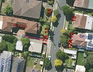
|
|
Title
|
Lot
101 DP 873782
|
|
Zoning
|
Low
Density Residential (R2)
|
|
Land
Use
|
Footpath
|
|
Description
|
This
narrow strip of land is a footpath to the side of Murphys lane.
As
the footpath is an operational use it is appropriate to classify the land as
operational land.
|
|
This
land serves as an important pedestrian link, providing access to adjacent
properties. Its function as a public footpath is consistent with Council's
objectives for local connectivity and aligns with permissible uses in the R2
zone. The footpath leads to the common property for the dwellings to the
north. The area of the land is approx. 17sqm.
The
land is not leased, and is not a public reserve.
|
|
Item 20
|
Parnell Street Car Park
|
|
Address
|
1-7
Parnell St, Strathfield
|
|
|
Title
|
Lot
1 DP 189327, Lot 26 DP83935 & Lot 2 DP 1099132
|
|
Zoning
|
Mixed
Use MU1
|
|
Land
Use
|
Car
Park
|
|
Description
|
1-7
Parnell Street is a small triangular car park between Parnell Street and the
railway reserve.
As
the carpark is an operational use it is appropriate to classify it as
operational land.
|
|
The
land was acquired by Council in 1964 and has been used as a car park ever
since. The car park has a 10-hour daytime parking restriction and fees are
payable and continues to support the parking needs of the surrounding
mixed-use area
The
land is not leased and is not a public reserve.
There
are no development approval records available, however the use of land as a
car park is permitted with consent in the MU1 zone. It has been used as a car
park since before the Burwood LEP commenced in 2012.
|
|
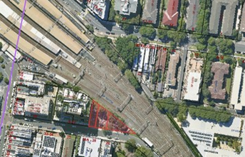
Item 21
|
Railway Square
|
|
Address
|
1a
Railway Pde Burwood
|
|
|
Title
|
Lot
2309 DP 1134547
|
|
Zoning
|
Mixed
Use MU1
|
|
Land
Use
|
Open
Space and Shop
|
|
Description
|
Railway
Square is a piece of land located between the railway and Railway Parade. A
shop is located within the former goods office on the site.
As
the shop is an operational use it is appropriate to classify as operational
land.
|
|
The
land consist of a railway post office building which is leased to tenants on
standard commercial leases, and the land is not a public reserve. Railway
Square serves dual purposes as public open space and a commercial venue. The
shop within the former goods office has relevant approvals and its use is
permissible under the current zoning. This multi-functional space contributes
to the vibrancy and amenity of the local area
|
|
Item 22
|
Seymour Street Car Park
|
|
Address
|
62
Seymour Street, Croydon Park
|
|
|
Title
|
Lot
10 DP 1901
|
|
Zoning
|
Local
Centre E1
|
|
Land
Use
|
Car
Park
|
|
Description
|
62
Seymour Street is a 16-bay carpark to the rear of buildings that front
Georges River Road, with access to the car park off Seymour Street.
As
the carpark is an operational use it is appropriate to classify it as
operational land.
|
|
This
car park has been a long-standing feature of the local area, supporting
nearby businesses and residents. Its use is consistent with the E1 zoning and
continues to play a vital role in local parking provision. The land is not
leased and is not a public reserve.
It
has been used as a car park since prior to the Burwood LEP commencing in
2012.
|
|
Item 23
|
Tangarra Street Car Park
|
|
Address
|
12
Tangarra St, Croydon Park
|
|
|
Title
|
Lot
1 DP 580519
|
|
Zoning
|
Local
Centre E1
|
|
Land
Use
|
Car
Park
|
|
Description
|
12
Tangarra Street is a carpark to the side of Tavistock Street with access to
the bays directly off Tavistock Street.
As
the carpark is an operational use it is appropriate to classify it as
operational land.
|
|
The
Tangarra Street Car Park has provided important parking facilities for the
local community for many years. Its ongoing use as a car park is consistent
with the current E1 zoning and local planning objectives. The land is not
leased and is not a public reserve.
There
are no development approval records available. It has been used as a car park
since prior to the Burwood LEP commencing in 2012.
|
|
Item 24
|
Victoria Street
|
|
Address
|
65a
Victoria St, Burwood
|
|
|
Title
|
Lot
B 370257
|
|
Zoning
|
Mixed
Use (MU1)
|
|
Land
Use
|
Car
Park
|
|
Description
|
65a
Victoria Street is a parcel of land used for a road and a footpath.
The
main use of the land is for road transport which is an operational use it is
appropriate to classify it as operational land.
|
|
This
land forms an integral part of the local road network, serving both vehicular
and pedestrian traffic. Its use as a road and footpath is consistent with the
MU1 zoning and supports local connectivity and accessibility. The land is not
leased and is not a public reserve.
The
use of land as for ‘roads’ is permitted without consent in the
MU1 zone. It has been used for these purposes since before the Burwood LEP
commenced in 2012.
|
|
Item 25
|
Wynne Avenue Car Park
|
|
Address
|
27-31
Belmore St Burwood
|
|
|
Title
|
Lot
6 SP 91971B
|
|
Zoning
|
Mixed
Use MU1
|
|
Land
Use
|
Car
Park
|
|
Description
|
The
Wynne Avenue Car park is a car park in the basement of 27-31 Belmore Street,
accessed off Wynne Avenue.
As
the carpark is an operational use it is appropriate to classify it as
operational land.
|
|
The
land was acquired by Council in 2019 and has been used as a car park ever
since. The car park has a 10-hour daytime parking restriction and fees are
payable.
The
land is not leased and is not a public reserve.
The
Wynne Avenue Car Park is a key piece of parking infrastructure in the area.
While specific approval details are not available, its use is consistent with
the current MU1 zoning and continues to meet local parking needs.
|
|
Item 26
|
41 Brighton Street
|
|
Address
|
41
Brighton St, Croydon
|
|
|
Title
|
Lot
2 DP 304375
(subject
to Sydney Water easement)
|
|
Zoning
|
Public
Recreation (RE1)
|
|
Land
Use
|
Dwelling
|
|
Description
|
41
Brighton Street is a residential dwelling.
As
the residential dwelling is an operational use it is appropriate to classify
it as operational land.
|
|
This
property, while zoned RE1, has historically been used for residential
purposes since its acquisition in 1975. The proposed inclusion in Schedule 1
of the LEP aims to regularise this long-standing use while maintaining
Council's flexibility for future planning in the area. The land has been
treated as community land and a Plan of Management exists for the land.
The
land is leased under a standard residential lease arrangement, and the land
is not a public reserve. There are no development approval records available.
A dwelling is a prohibited land use in the RE1 zone and it is proposed to
include the land in Schedule 1 of the LEP, Additional Permitted Uses.
|
|
Item 27
|
43 Brighton Street
|
|
Address
|
43
Brighton St, Croydon
|
|
|
Title
|
Lot
13 DP 18849;
Lot
2 DP 629656; and
Lot
3 DP 304375
|
|
Zoning
|
Public
Recreation (RE1)
|
|
Land
Use
|
Childcare
Centre
Recreation
Facilities (Outdoor)
|
|
Description
|
43
Brighton Street is childcare centre and a tennis centre.
As
the uses are operational use it is appropriate to classify it as operational
land.
|
|
The
land was acquired by Council by way of transfer in the 1970’s. This site
accommodates both a childcare centre and tennis facilities, providing
operational and community services. These uses are permissible under the
current RE1 zoning and have been established features of the local area for
many years. The land has been treated as community land and a Plan of
Management exists for the land.
The
land is leased under a standard commercial lease arrangement, and the land is
not a public reserve. There are no development approval records available.
Childcare centres and Recreation Facilities (Outdoor) are permitted with
consent’ in the RE1 zone. It has been used as a childcare centre and a
tennis centre since before the Burwood LEP commenced in 2012.
|
|
Item 28
|
Jackett Reserve and 39 Minna Street
|
|
Address
|
39
Minna Street, Burwood (also known as 8 Belgrave Street) in Jackett Reserve
|
|
|
Title
|
Lot
6 & 7 Sec 2 DP233 and Lot 2 DP 201156
|
|
Zoning
|
Public
Recreation (RE1)
|
|
Land
Use
|
Park
and Childcare Centre
|
|
Description
|
39
Minna Street is a childcare centre within Jackett Reserve.
|
|
The
acquisition date for this land is not specified in Council records. It has
been used as a park and childcare centre for many decades. There are no
development approval records available. Childcare centres and Recreation
Facilities (Outdoor) are permitted with consent in the RE1 zone. It has been
used for these purposes since before the Burwood LEP commenced in 2012 The
land has been treated as community land and a Plan of Management exists for
the land.
It
is proposed to reclassify the land to operational for the purposes of
subdivision. Following subdivision the Childcare centre will remain
operational land as it is an operational use, and the park will return to
community land as a park is a community land use.
There
are no development approval records available. Childcare centres and
Recreation Facilities (Outdoor) are permitted with consent’ in the RE1
zone. It has been used as a childcare centre and park since before the
Burwood LEP commenced in 2012.
|
|
Item 29
|
SES Building
|
|
Address
|
32-34
Cheltenham Rd Croydon
|
|
|
Title
|
Lot
3 DP 1198616
|
|
Zoning
|
Low
Density Residential (R2)
|
|
Land
Use
|
Emergency
Services Facility
|
|
Description
|
32-34
Cheltenham Road is an operations building for the State Emergency Service
As
the residential dwelling is an operational use it is appropriate to classify
it as operational land.
|
|
Council
records do not provide a specific acquisition date for this land. It has been
used as an emergency services facility for many years. There are no
development approval records available. Emergency Services Facilities are
permitted with consent in the R2 zone. It has been used as an emergency
services facility since before the Burwood LEP commenced in 201. The land has
been treated as community land and a Plan of Management exists for the land.
The
land is leased to the SES under a memorandum of understanding agreement, and
the land is not a public reserve. There are no development approval records
available. Emergency Service Facilities are permitted with consent’ in
the R2 zone. It has been used as an emergency services facility since before
the Burwood LEP commenced in 2012.
|
|
Item 30
|
Woodstock Childcare Centre
|
|
Address
|
22
Church St Burwood (incorporating 92 Fitzroy Street Burwood)
|
|
|
Title
|
PART
Lot 2 DP 605138 (Council),
|
|
Zoning
|
Low
Density Residential (R2)
|
|
Land
Use
|
Childcare
Centre
|
|
Description
|
This
is the childcare centre at 92 Fitzroy Street.
As
the uses are operational use it is appropriate to classify it as operational
land.
|
|
The
acquisition date for this land is not specified in Council records. It has
been used as a childcare centre since 2007 and has been leased to a childcare
operator since this time.
Childcare
centres are permitted with consent in the R2 zone. It has been used as a
childcare centre since before the Burwood LEP commenced in 2012. The land has
been treated as community land and a Plan of Management exists for the land.
It
is proposed to reclassify the land to operational for the purposes of
subdivision. Following subdivision the Childcare centre will remain
operational land as it is an operational use, and the remainder will return
to community land as it is a community land use.
There
are no development approval records available, but it is believed that
consent occurred in 2006-2007.
|
|
Item 31
|
Burwood Council Offices
|
|
Address
|
8
Conder Street Burwood
|
|
|
Title
|
Lot
105 in DP1258893
|
|
Zoning
|
Mixed
Use MU1
|
|
Land
Use
|
Office,
Shop, Community Facility
|
|
Description
|
As
the uses are operational use it is appropriate to classify it as operational
land.
|
|
The
Burwood Council Administration Centre site was dedicated to Council in 2020
as part of a comprehensive redevelopment project by way of a Voluntary
Planning Agreement. The mixed-use nature of the site, incorporating office,
retail, and community facilities, aligns with the strategic objectives for
the area and has relevant development approvals in place. The Burwood Council
Offices site incorporates a mix of administrative, retail, and community
uses. These uses are permissible under the current MU1 zoning and reflect the
site's importance as a civic and community hub. This site is central to
Council's operations and
service delivery. Classifying it as operational land will facilitate more
efficient management and potential future adaptations to meet changing
administrative and community service needs.
The
use of land as a shop is permitted with consent in the MU1 zone. It has been
used as a shop since before the Burwood LEP commenced in 2012. The land has
been used as an office and community facility ever since. The land has been
treated as community land and a Plan of Management exists for the land.
Part
of the land is leased under a standard commercial lease arrangement, and the
land is not a public reserve.
Consent
for the development was issued in 2015, and the use of land as a shop is
permitted with consent in the MU1 zone.
|
In support of the Planning Proposal:
· Attachment
1 contains the draft Planning Proposal Report in the format required by the
Department of Planning, Housing and Industry (DPHI). This report contains
detailed information on the planning proposal and for each item proposed to be
reclassified.
· Attachment
2 is a Practice Note produced by the Department which explains the process
of classifying land and indicates the information that should be provided in
the Planning Proposal report at Attachment 1.
· Attachment
3 is a copy of the Local Environment Plan Making Guideline produced by the
Department which explains the local plan making process
The Planning Proposal intends to
classify 31 items from “Community Land” to “Operational
Land.” These items comprise a range of locations that are owned by
Council and used for operational purposes and should be classified as
operational land under the Burwood Local Environmental Plan 2012.
A Ministerial Direction requires
all planning proposals to be considered by the Local Planning Panel for advice
prior to consideration of the planning proposal by Council. The role of the
Local Planning Panel is to provide advice to Council to assist their
consideration of the planning proposal. Should Council resolve to support the
planning proposal it will be forwarded to DPHI for their consideration to grant
Gateway approval. If approved, the Gateway determination will include details
of necessary community consultation, following which the planning proposal will
again be considered by Council.
This planning proposal does not
involve actual development, such as a rezoning or change of planning controls, and
will not alter current use or operational practice but rectify any historical
anomalies in land classifications under Council’s Environmental Planning
Instrument via a change to the classification of land under the LG Act.
The professional and independent
advice of the Burwood Local Planning Panel (BLPP) has been included in this
subsequent report to Council as well as the minutes of the Local Planning Panel
meeting.
At its Meeting of 12 November
2024, the Burwood Local Planning Panel considered the draft Planning Proposal
Report in relation to the Reclassification of certain Council-Owned Land and
advised Council to proceed with the proposed reclassification as outlined in the
attached Planning Proposal Report subject to the following advice:
1. That the draft Planning Proposal Report be expanded
to research the matter in which each property came into Council’s
ownership.
2. Should the Council’s ownership have come by
way of dedication or gift or resumption for a specific purpose and therefore
whether the property is subject to a trust for public purposes, not necessarily
a statutory trust.
3. If the land is subject to a trust for public
purposes that land should remain community land.
4. Given that the Council has chosen to use the LEP
process, the draft Planning Proposal Report is to clearly articulate a planning
purpose for the LEP.
5. Where the Council considers that land is currently
used for an operational purpose that use should be detailed sufficiently to
differentiate it from a community purpose.
Following the BLPP's advice,
Council conducted additional research through its Local Heritage Library,
further assessing its historical records to thoroughly investigate how the
properties came into Council's ownership. After exhausting all available
information sources, Council is satisfied it has fulfilled the BLPP's
recommendations on this matter. A copy of the relevant BLPP minutes is
contained in Attachment 4.
Community Consultation
Consultation on this planning
proposal will be undertaken during a formal 28 day exhibition period in
accordance with the Environmental Planning and Assessment Regulations and
Council’s Community Engagement Strategy, should DPHI determine to grant
Gateway approval for the planning proposal. Following the exhibition period
Council will undertake a public hearing as required for reclassification
planning proposals.
A public hearing must be
undertaken when reclassifying public land from community to operational
(EP&A Act s.57 & LG Act s.29). This gives the community an opportunity
to expand on written submissions and discuss issues with an independent person
in a public forum. After the exhibition period has ended, at least 21 days
public notice is to be given before the hearing. This allows the person
chairing the hearing sufficient time to consider written submissions and all
issues raised. There are specific requirements for the independence of the
person chairing the hearing, their preparation of a public hearing report and
council making the report publicly available (LG Act s.47G).
Planning or Policy Implications
The proposed reclassification of
certain Council-owned land from Community to Operational aligns with key
strategic objectives outlined in Council's Property Strategy and Operational
Plan. It supports the goals under Council’s Community Strategic Plan of
complying with financial management responsibilities to promote transparency
and accountability (A.102) and managing Council's property portfolio to
optimise financial returns from Council-owned properties (A.104).
This reclassification aims to
accurately reflect the current and intended use of these properties, many of
which have dual operational and community functions. This update will not alter
current use or operational practice but rectify any historical anomalies in
land classifications under Council’s Environmental Planning Instrument.
It is crucial to emphasise that this proposal does not seek to reclassify
land that is clearly and solely for community use, such as community centres.
This careful approach is designed to maintain the integrity of genuine
community spaces whilst addressing the restrictions of attracting commercial
operations to activate community land for the community.
By reclassifying these selected
properties, Council will gain greater flexibility in their management, allowing
for more efficient use in line with Council's strategic goals. This proposal aligns
with best practices in local government asset management, ensuring that land
classification accurately reflects its use and potential. The reclassification
will provide Council with the tools to better serve the community's needs while
maintaining responsible stewardship of public assets.
Financial Implications
The proposed reclassification has
several potential financial implications that align with Council's commitment
to responsible asset management. Primarily, reclassification to Operational land
will enhance revenue opportunities by allowing Council to attract market rates
for leasing and licensing of these properties. It will also permit Council to
enter into longer-term leases beyond the current 21-year limit for Community
land, potentially attracting more stable, long-term tenants and allowing
consistency in community service offerings, such as childcare centres, whereby
they become restricted in making much needed fit-out improvements given the
restricted lease terms.
This optimised approach to
property management could increase revenue from these assets. Importantly, the
revenue generated from these properties can be redirected towards community
needs and services, creating a positive cycle of community benefit. This aligns
with Council's goal of using its resources efficiently to support and enhance
community services and infrastructure.
The reclassification may also
lead to a reduced administrative burden as Operational land classification can
streamline some aspects of property management compared to the specific
requirements for Community land.
This reclassification does not
alter the current use of these properties or change Council's commitment to
maintaining these assets for community benefit. Instead, it provides Council
with an ability to rectify historical anomalies and the flexibility to make
strategic decisions about these assets in the future, always prioritising the
community's best interests. The potential financial benefits of this
reclassification could provide additional resources for enhancing community
services and infrastructure, supporting Council's ongoing commitment to serving
the needs of our residents.
Conclusion
This report proposes updating the
Burwood Local Environmental Plan 2012 (BLEP) through a planning proposal under
the Environmental Planning and Assessment Act 1979 (EPA Act) to reclassify
certain Council-owned public land from Community Land to Operational Land under
the Local Government Act 1993 (LG Act). This change will not affect current use
or operations but will correct historical classification anomalies in the
Council’s Environmental Planning Instrument.
If Council supports the proposal,
it will be submitted to the Department of Planning, Housing and Infrastructure
(DPHI) for Gateway approval. If approved, Council will commence community
consultation and a public hearing in accordance with legislative requirements
before the proposal returns to Council for further consideration.
Recommendation(s)
1. That Council resolves to
support the preparation and submission to the NSW Department of Planning,
Housing and Infrastructure (DPHI) a request for Gateway Determination of a
Planning Proposal to update the Burwood Local Environmental Plan 2012 (BLEP)
to:
a) Reclassify certain
Council-owned land from Community Land to Operational Land under the Local
Government Act 1993 (LG Act) and Schedule 4 of BLEP to correctly reflect
the use of specified sites as listed in this report.
b) Include additional permitted land
uses under Schedule 1 of BLEP for certain Council-owned land to correctly
reflect the use of specified sites as listed in this report.
2. That subject to a DPHI Gateway
Determination, a minimum 28 day community consultation and engagement process
be undertaken and a public hearing be undertaken in accordance with the
Environmental Planning and Assessment Act 1979 and Local Government Act 1993.
3. That
the General Manager be delegated to undertake minor modifications to any
numerical, typographical, interpretation and formatting errors, if
required.
4. That
the results of the Gateway request, community consultation and engagement
process and public hearing be reported back to Council.
Attachments – See separate Attachments Paper
1⇨
Draft Planning Proposal Report - Reclassification of Certain
Council owned land - February 2025
2⇨
DPHI Practice Note Reclassification Public Land via LEP
3⇨
DPHI LEP Making Guideline
4⇨
BLPP Minutes November 2024
Council
Meeting 11 February 2025
(Item 4/25) Half-Yearly Report - June
to December 2024
File No: 25/2427
Report by Director People & Performance
Summary
A report on the progress of
Council’s Delivery Program 2022 – 2026 is to be presented to
Council on a half-yearly basis in accordance with legislative requirements of
the State Government’s Integrated Planning and Reporting (IP&R)
Framework.
Operational Plan Objective
P.43 – Plan, monitor and
report on the delivery of services and initiatives in accordance with the
Integrated Planning and Reporting Framework under the Local Government Act.
Background
Council’s Integrated
Planning & Reporting (IP&R) documentation reports information in a
transparent and streamlined process to provide easy access to information for
residents.
Reflecting the IP&R
Framework, reporting follows the structure of the Delivery Program 2022 –
2026 and Operational Plan 2024 – 2025, which delivers upon the strategic
goals identified by the community in the Burwood2036 Community Strategic Plan.
This Half-Yearly Report is the
first report for the Operational Plan 2024 – 2025 covering the period
from 1 July 2024 to 31 December 2024.
The strategic goals are divided
into five themes:
· Inclusive
community & culture
· Places
for people
· Sustainable
& protected environment
· Vibrant
city & villages
· Open
& collaborative leadership
Each strategic goal is divided
into actions which represent the specific initiatives Council proposes to
implement to achieve the identified targets. The Delivery Program includes a
total of 149 actions which are incorporated into the Operational Plan.
Reporting Structure
Key users are required to provide
a rating status and comment for each strategic action they are responsible for
as follows:
|
Completed
|
An action has been completed
during the reporting period.
|
|
On Track
|
The action is on track for
completion as scheduled.
|
|
Not Due to Start
|
The action is not due to start
during the reporting period.
|
|
Monitor
|
The action is underway, but may
not be completed in time or it has been postponed.
|
These requirements support and
promote a continuous risk evaluation process for staff and management which
allows the identification of risks and opportunities at an early stage in the
delivery of activities/projects.
Measuring our Success
For the period 1 July 2024 to 31 December 2024, Council has
registered the following progress:
|
Status
|
Number
|
|
Completed
|
21
|
|
On Track
|
106
|
|
Not Due to Start
|
5
|
|
Monitor
|
8
|
|
Total
|
140
|
Some significant milestones during this timeframe include:
· In
September 2024, the Local Government elections were held, and our Councillors
were elected for a new four-year term.
· Council’s focus on creating an inclusive Burwood
continued with key actions from the Disability Inclusion Action Plan rolled out
and International Day for People with Disability celebrated in early December
2024.
· Over 60% of the actions set out in the Multicultural
Burwood Plan have been delivered including Aboriginal Cultural Awareness
Training and the Culture Talks Forum.
· Implementation of the Year 1 actions from the Burwood
Youth Action Plan commenced including a webpage on Council’s website
designed for young people in collaboration with the Burwood Youth Advisory
Group.
· The trial of the Burwood Library After Dark service
commenced providing after-hours access to community members participating in
the trial.
· The use of Council’s facilities and sporting
fields continued to be strong with 2,744 bookings of community centres, halls
and the Community Hub, and 1,399 sporting field bookings.
· October 2024 saw Council celebrate Small Business
Month hosting a free networking event in the Library and Community Hub with
over 50 local business owners in attendance.
· The Mobile Play Van had approximately 2,370 families
visit with a total number of 5,720 attendees.
· The draft of Council’s inaugural Reflect
Reconciliation Plan was developed in consultation with First Nations
stakeholders, community members, local schools, services and staff.
· Council delivered the final scheduled events and
activities for the Burwood Council Sesquicentenary including a Special Council
Meeting held on Wednesday, 24 July 2024.
· Significant progress was made on the delivery of
Council’s Western Sydney Infrastructure Grant (WSIG) Program projects
with the commencement and completion of key milestones including community
consultation, progression from draft to detailed design and preparation for
major construction.
· New creative programs were rolled out in the Library
and Community Hub including ‘Creative Kids’ and ‘Creative
Seniors’.
· 740 program classes were made available at the Enfield
Aquatic Centre and 2,646 student bookings were received for Council’s
Learn to Swim Program.
· The implementation of Council’s Child Safe
Standards continued with actions including the inclusion of Child Safety
obligations in the Councillor induction, update of the ‘Children in the
Library Corporate Practice’ and physical improvements to improve child
safety in Council facilities.
· A number of key events were delivered to the Burwood
community including Burwood Culture Streets, an expanded Greek Street Fair,
Christmas in Croydon and Carols in the Park.
· 12 additional Chinatown Night Markets road closure
activations were delivered on Clarendon Place.
· 108 Burwood residents received their Australian
citizenship at two ceremonies held during the reporting period.
· The Flockhart Park Playground upgrade and installation
of five new Outdoor Fitness Stations were completed with funding from the NSW
Government’s Infrastructure Grants program.
· The WSIG park expansion projects at Portland and
Russell streets were completed.
· 15 applications for Council’s Shopfront
Improvement Program were approved with a total funding amount of $44,703 being
made available.
· The Burwood Art Prize opened in November 2024 with an
overall prize pool of $25,000 (previously $14,000) with sponsorship of $10,000
from the Anson Group.
· Seven public art projects were completed including the
Burwood Mayoral Portraits, Burwood Uniting Church Mural and the Happy Nest on
the Burwood Nest.
· A comprehensive audit of Burwood’s cultural
assets was completed with more than 2,000 cultural assets identified.
· 10 new mobile Customer Service pop-up stalls across
various locations were held, and Council’s overall customer experience
rating was 8.0 out of 10 from 6,776 ratings.
· The implementation of a single Enterprise Resource
Planning (ERP) solution continued enhancing service delivery and increasing
efficiencies.
· 159 projects were exhibited on Participate Burwood
with 26,776 views by 11,501 visitors; 916 project contributions by 556
contributors were received.
Consultation
Once the Half-Yearly Report is
endorsed by Council, it will be made available to the public on Council’s
website.
Planning or Policy
Implications
In accordance with s 404 of the Local
Government Act 1993 the General Manager must provide progress reports to
Council, at least every six months, as to its progress with respect to the
principal activities detailed in Council’s Delivery Program. Burwood
Council’s Operational Plan 2024 to 2025 requires that public information
is made available in a timely manner.
Financial Implications
No Financial implications.
Conclusion
Council’s Delivery Program
2022 – 2026, Operational Plan 2024 – 2025 and the Half Yearly
Report 1 July 2024 to 31 December 2024 provides Council with ongoing updates on
the progress of the objectives identified in Council’s Delivery Program
and Operational Plan.
Recommendation(s)
That
Council endorse the Half-Yearly Report 1 July 2024 to 31 December 2024.
Attachments – See separate Attachments Paper
1⇨
Burwood Council - Half-Yearly Report - December 2024
Council
Meeting 11 February 2025
(Item 5/25) Councillor Expenses and
Facilities Policy - Adoption
File No: 25/5374
Report by Acting Director Corporate Services
Summary
Section 252 (1) of the Local
Government Act 1993 (the Act) requires that the Council must, within the
first 12 months of each term of Council, adopt a policy concerning the payment
of expenses incurred and facilities provided to the Mayor and Councillors. The
revised Councillor Expenses and Facilities Policy has been publicly
exhibited and is now presented to Council for adoption.
Operational Plan Objective
P.49 Ensure transparency and
accountability in decision making
Background
The Policy had been revised to
ensure compliance with the Act, the Local Government (General) Regulation
2021, the Office of Local Government (OLG) Guidelines, and the OLG
Councillor Expenses and Facilities Policy Better Practice Template.
At its meeting of 10 December
2024, Council resolved to place the revised Councillors Expenses and
Facilities Policy on public exhibition for a period of 28 days.
Consultation
The draft Councillors Expenses
and Facilities Policy was on public exhibition for 45 days from 17 December
2024 to 31 January 2025, allowing additional time for consideration and
comment.
Council advertised the draft
policy:
· via
Participate Burwood on Council’s website, and
· in
multiple editions of the Burwood Community Update e-Newsletter.
No submissions were received.
Planning or Policy
Implications
The policy is consistent with OLG
Guidelines and the OLG Councillor Expenses and Facilities Policy Better
Practice Template.
The revised policy does not
propose major changes and many of the existing expense limits have been
retained. Other provisions, such as those relating to ICT equipment, telephony
expenses and e-parking permits, have been updated to reflect current
requirements. No further changes are proposed.
The proposed policy is provided
at Attachment 1. Once adopted, the new Councillors and Expenses
Policy will supersede the current policy.
Financial Implications
The proposed limits contained within the proposed policy are
consistent with existing budgets.
Conclusion
The proposed Councillor
Expenses and Facilities Policy is in line with modern local government
practices supporting transparency and accountability around the allocation and
use of funds.
Recommendation(s)
That Council:
1. Adopts the revised Councillor Expenses and
Facilities Policy appearing at Attachment 1 to this report.
2. Retires the Councillor Expenses and
Facilities Policy adopted by Council on 28 June 2022.
Attachments
1⇩
Draft Councillor Expenses and Facilities Policy
Item Number 5/25 - Attachment 1
Draft Councillor Expenses
and Facilities Policy
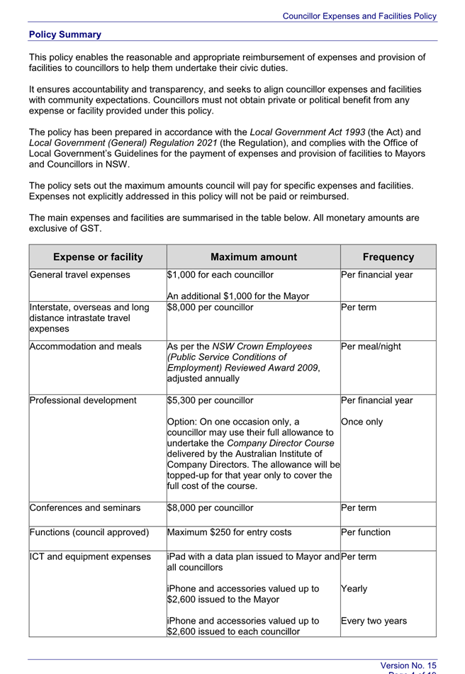
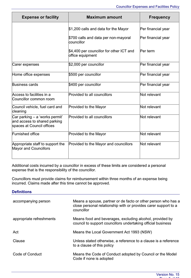
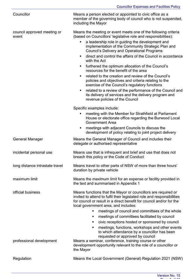
Council
Meeting 11 February 2025
(Item 6/25) Budget Review for Quarter
Ending 31 December 2024
File No: 25/3892
Report by Acting Director Corporate Services
Summary
The 2024–2025 Budget was
adopted at the Council Meeting held on 25 June 2024 with a deficit of
$1,522,000, with the operating result including capital grants and
contributions forecast to be a surplus of $30,319,000.
The following Statement of Budget
Income and Expenditure identifies a forecast deficit of $2,898,000 as at 31
December 2024, with the operating result including capital grants and
contributions forecast to be a surplus of $29,670,000.
Operational Plan Objective
2.3.1 Identify and maintain additional revenue sources to
ensure financial sustainability
Background
Included in this report is the
budget forecast of Income Statement which is based on external and internal
reporting consolidations to improve the transparency and consistency of
reported information. This statement forms part of a group of statements that
must be reported to Council on a quarterly basis in accordance with Clause
202(3) of the Local Government (General) Regulation 2021. These
statements are known as the Quarterly Budget Review Statements (QBRS).
Council's budget is prepared on a
program basis and forecasts expected operating and capital income and
expenditure for the year. To fund the budget, Council also utilises funds held
in reserve that have accumulated in prior years such as Section 7.12 Local
Infrastructure Contributions and Internally Restricted Reserves.
The Local Government Code of
Accounting Practice and Financial Reporting requires Council to prepare its
General Purpose Annual Financial Reports in accordance with the Australian
Accounting Standards. The major implications are that Council must adopt a
general purpose format for financial reporting.
This requires Council to:
§ implement full
accrual accounting, including capitalisation of infrastructure assets
§ prepare consolidated
financial statements incorporating all functions and entities under the control
of Council
§ adapt to a change in
accounting focus from the fund result for the year (i.e. the movement in
working funds) to the gain/(loss) from ordinary activities
Each of these requirements is
applied at the time of preparing the Annual Financial Reports at 30 June each
year. However, with respect to the budget process Council is still focusing on
the funding result of reporting. The financial result for the year is
determined and audited and the Financial Reports and Auditor's Report are
included in Council's Annual Report.
Summary of Movements
A summary of Councils revised budget for 2024–25 and a
summary of budget movements have been included in this report:
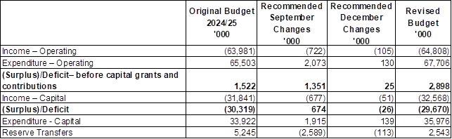
Income – Operational
- $50,000
increase in Fees and Charges, including;
o $50,000 increase restoration
income
- $55,000
increase in Operating Grants and Contributions, including;
o $35,000 increase due to grant
received for Cyber Security Awareness
Expenditure – Operational
- $130,000
increase in Material and Services, including;
o $35,000 increase due to grant
received for Cyber Security Awareness
o $50,000 increase for Wangal
Park offset by increased income received from restorations income
Income – Capital
- $51,000
increase in Capital Grants and Contributions, including;
o $51,000 increase due to
additional grant funds received for Roads to Recovery
Expenditure – Capital
- $139,000
increase in Material and Services, including;
o $51,000 increase due to
additional grant funding received for Roads to Recovery
o $88,000 increase for
completion of the replacement parking meters funded from reserves
Reserve Transfers
- $113,000
increase in Reserve Transfers, including;
o $88,000 increase in transfer
from parking meter reserve for replacement of parking meters
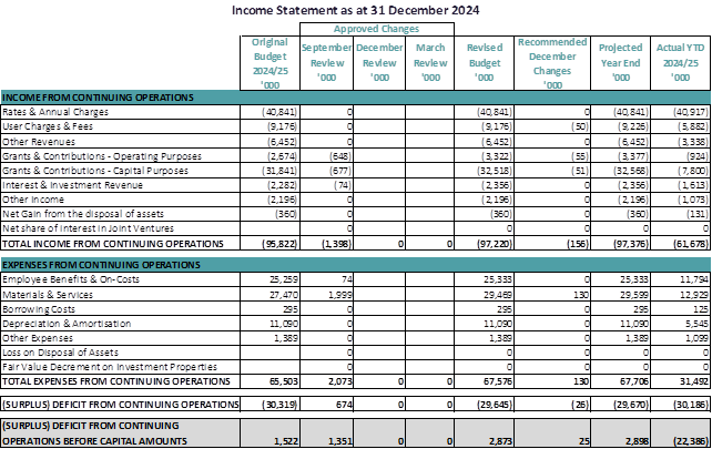
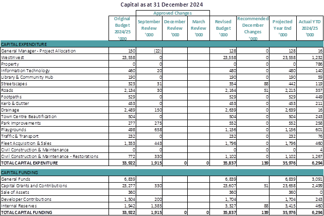
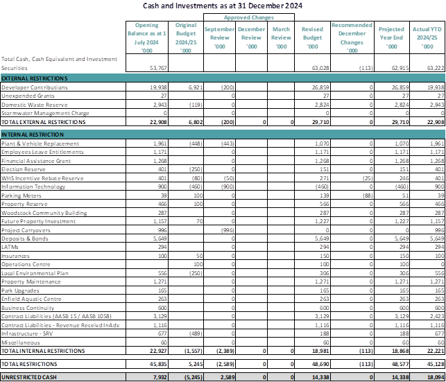
Council’s Current
Unrestricted Cash is distorted as Council has received a high volume of rate
revenue as at 31 December 2024. The Unrestricted Cash figure will fluctuate
during the year as it will be used to fund planned expenditure.
Cash
The bank reconciliation has been completed as at 31 December
2024.
Investments
Council’s investments have
been made in accordance with its Investment Policy and the Investment
Guidelines issued by the Minister for Local Government at the time of their
placement. As at 31 December 2024, Council’s cash and investment
portfolio stood at $63,222,023. Council’s Investments are tabled on a
monthly basis as a separate report.
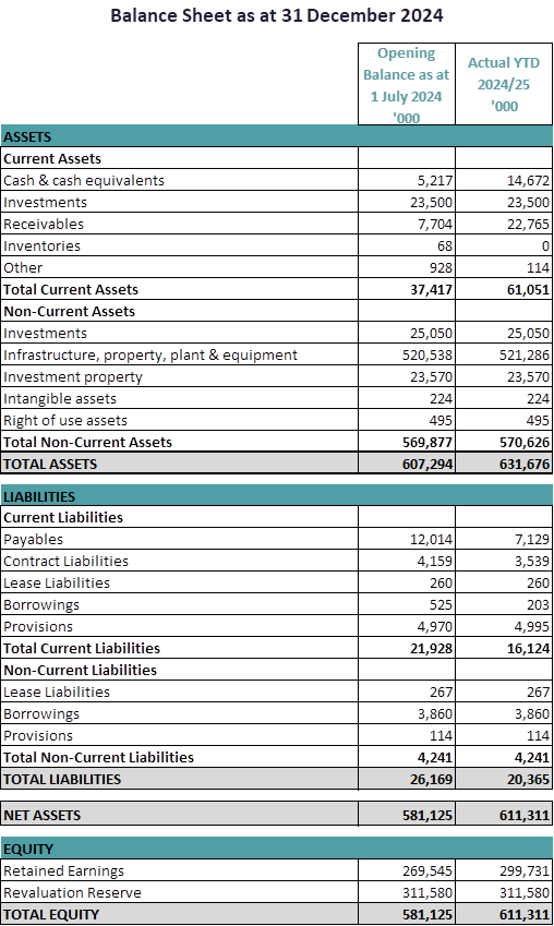
Key Performance indicators
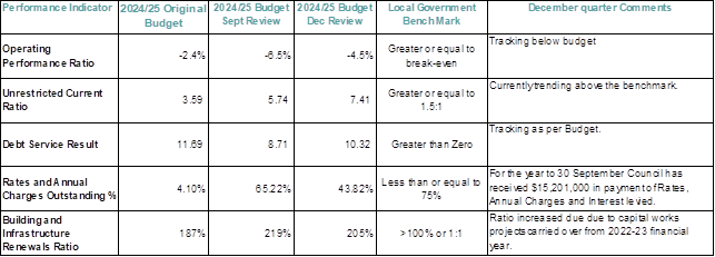
Contracts Listing

Notes:
1. Minimum
reporting level is 1% of estimated income from continuing operations or $50,000
whichever is the lesser.
2. Contracts
to be listed are those entered into during the quarter and have yet to be fully
performed, excluding contractors that are on Council’s preferred supplier
list
3. Contacts
for employment are not required to be included.
4. Where
a contract for services, etc. was not included in the budget, an explanation is
to be given (or reference made to an explanation in another Budget Review
Statement)
Legal Expenses
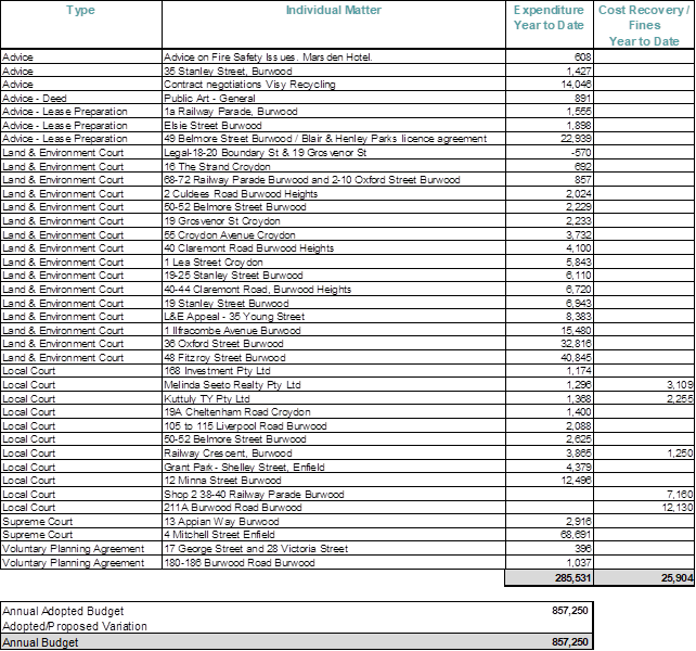
Conclusion
The current forecast budget
result and the variation identified as part of the 31 December 2024 Quarter
review have been undertaken by the Executive Team and the Finance Manager.
There were also minor income and expenditure changes made throughout the budget
which has increased the revised projected deficit.
The
following statement, by the Responsible Accounting Officer, is made in
accordance with Clause 203(2) of the Local Government (General) Regulation 2021.
“It
is my opinion that the Quarterly Budget Review Statement for Burwood Council
for the quarter ended 31 December 2024 indicates that Council's projected
financial position will be satisfactory at year end 30 June 2025, having regard
to the projected estimates of income and expenditure and the original budgeted
income and expenditure.”
Recommendation(s)
1. That the Budget Review Statement of the 2024–25
Budget as at 31 December 2024, including the statement by the Responsible
Accounting Officer, Finance Manager, be received and noted.
2. That in accordance with Clauses 203 and 211
of the Local Government (General) Regulation 2021, the revised estimates
of income and expenditure for 2024-25 surplus of $29,670,000, as shown in the
report be approved and that Council’s budget be adjusted accordingly and
that the expenditure and income variations projected in the report and the
transfers to and from External and Internal restricted Reserves be approved.
Attachments
There are no attachments for this report.
Council
Meeting 11 February 2025
(Item 7/25) Investment Report as at 30
November 2024 and 31 December 2024
File No: 25/3901
Report by Director Corporate Services
Summary
In accordance with Clause 212 of
the Local Government (General) Regulation 2005, this report details all
money that Council has invested under Section 625 of the Local Government
Act 1993.
Operational Plan Objective
A.103 Implement and monitor appropriate
investment strategies and prepare monthly investment reports.
Background
As provided for in Clause 212 of
the Local Government (General) Regulation 2005, a report listing
Council’s investments must be presented to Council.
Council’s investments are
made up of a number of direct investments, some of which are managed or advised
by external agencies.
Investment Portfolio
Council has a diversified
investment portfolio and has a number of direct investments in term
deposits. Its investment portfolio as at 30 November 2024 is:
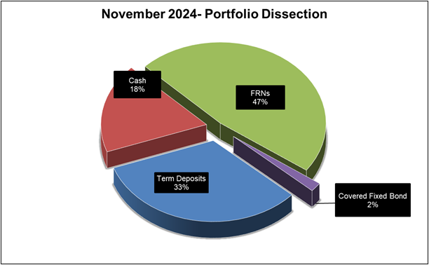
As at 30 November 2024 Council
held the following term deposits:
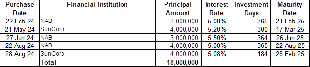
As at 30 November 2024 Council
held the following covered fixed bonds:

As at 30 November 2024 Council
held the following Floating Rate Notes:
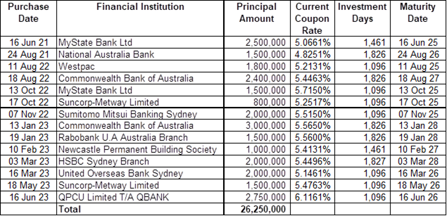
Its investment portfolio as at 31
December 2024 is:
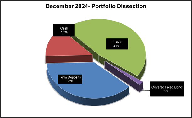
As at 31 December 2024 Council
held the following term deposits:
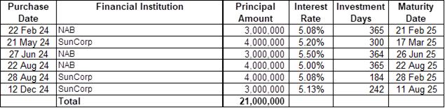
As at 31 December 2024 Council
held the following covered fixed bonds:
As at 31 December 2024 Council
held the following Floating Rate Notes:
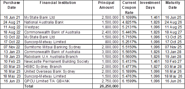
The following graph highlights
Council’s investment balances for the past 12 months:
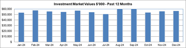
Council’s investment
portfolio is recognised at market value and some of its investments are based
on the midpoint valuations of the underlying assets and are subject to market
conditions that occur over the month.
Council’s investment
balances as at reporting date are detailed in Attachment 1 & 2. Definitions
on the types of investments are detailed in Attachment 3.
Investment Performance and
Market Commentary
At the Reserve Bank of Australia
(RBA) meeting on the 10 December 2024, the Board decided to leave the official
cash rate at 4.35 per cent. According to the Statement by the Reserve Bank
board "…Inflation has fallen substantially since the peak in 2022,
as higher interest rates have been working to bring aggregate demand and supply
closer towards balance. Measures of underlying inflation are around
3½ per cent, which is still some way from the 2.5 per cent
midpoint of the inflation target.
The most recent forecasts
published in the November Statement on Monetary Policy (SMP)
do not see inflation returning sustainably to the midpoint of the target until
2026. The Board is gaining some confidence that inflationary pressures are declining
in line with these recent forecasts, but risks remain.
While underlying inflation is
still high, other recent data on economic activity have been mixed, but on
balance softer than expected in November.
Growth in output has been weak.
National accounts for the September quarter show that the economy grew by only
0.8 per cent over the past year. Outside of
the COVID-19 pandemic, this is the slowest pace of growth since the
early 1990s. Past declines in real disposable income and the ongoing effect of
restrictive financial conditions continued to weigh on household consumption
spending, particularly on discretionary items.
A range of indicators suggest
that labour market conditions remain tight; while those conditions have been
easing gradually, some indicators have recently stabilised. The unemployment
rate was 4.1 per cent in October, up from 3.5 per cent in
late 2022. That said, employment grew strongly over the three months to
October, the participation rate remains close to record highs, vacancies are
still relatively high and average hours worked have stabilised. At the same
time, some cyclical labour market indicators, including youth unemployment and
underemployment rates, have recently declined.
Wage pressures have eased more
than expected in the November SMP. The rate of wages growth as measured by the
Wage Price Index was 3.5 per cent over the year to the September
quarter, a step down from the previous quarter, but labour productivity growth
remains weak.
Taking account of recent data,
the Board’s assessment is that monetary policy remains restrictive and is
working as anticipated. Some of the upside risks to inflation appear to have
eased and while the level of aggregate demand still appears to be above the
economy’s supply capacity, that gap continues to close.
The central projection is for
growth in household consumption to increase as income growth rises. September
quarter data suggest that both incomes and consumption had recovered a little
slower than forecast, but more recent information has suggested a pick-up in
consumption in October and November. There is a risk that any pick-up in
consumption is slower than expected, resulting in continued subdued output
growth and a sharper deterioration in the labour market. More broadly, there are
uncertainties regarding the lags in the effect of monetary policy and how
firms’ pricing decisions and wages will respond to the slow growth in the
economy and weak productivity outcomes at a time of excess demand, and while
conditions in the labour market remain tight.
There remains a high level of
uncertainty about the outlook abroad. Most central banks have eased monetary
policy as they become more confident that inflation is moving sustainably back
towards their respective targets. They note, however, that they are removing
only some restrictiveness and remain alert to risks in both directions, namely
weaker labour markets and stronger inflation. Geopolitical uncertainties remain
pronounced.
Sustainably returning inflation
to target within a reasonable timeframe remains the Board’s highest
priority. This is consistent with the RBA’s mandate for price stability
and full employment. To date, longer term inflation expectations have been
consistent with the inflation target and it is important that this remains the
case.
While headline inflation has
declined substantially and will remain lower for a time, underlying inflation
is more indicative of inflation momentum, and it remains too high. The November
SMP forecasts suggest that it will be some time yet before inflation is
sustainably in the target range and approaching the midpoint. Recent data on
inflation and economic conditions are still consistent with these forecasts,
and the Board is gaining some confidence that inflation is moving sustainably
towards target.
The Board will continue to rely
upon the data and the evolving assessment of risks to guide its decisions. In
doing so, it will pay close attention to developments in the global economy and
financial markets, trends in domestic demand, and the outlook for inflation and
the labour market. The Board remains resolute in its determination to return
inflation to target and will do what is necessary to achieve that
outcome.”
The following graph provides
information on the current RBA monetary policy:
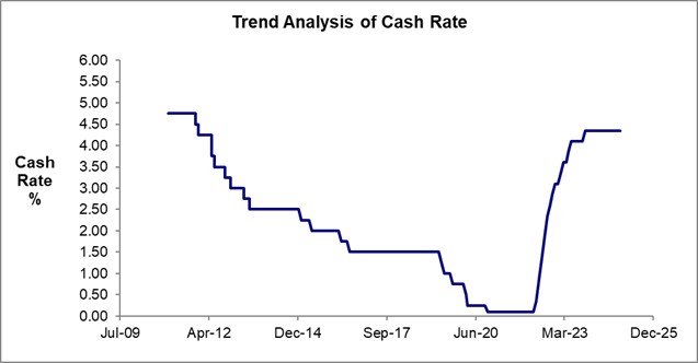
Recommendation(s)
1. That the investment report for 30 November
2024 and 31 December 2024 be received and endorsed.
2. That the Certificate of the Responsible
Accounting Officer be received and noted.
Attachments
1⇩
Investment Register November 2024
2⇩
Investment Register December 2024
3⇩
Investment Types
Item Number 7/25 - Attachment 1
Investment Register
November 2024

Item Number 7/25 - Attachment 2
Investment Register
December 2024
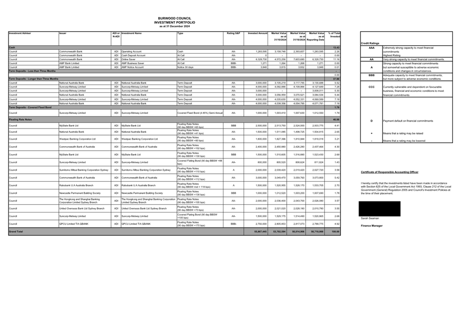
Item Number 7/25 - Attachment 3
Investment Types
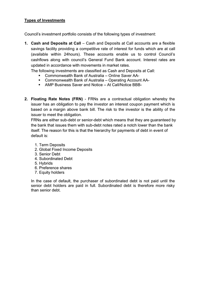
Council
Meeting 11 February 2025
(Item 8/25) Amendment of Council
Meeting dates for 2025
File No: 25/5623
Report by Acting Director Corporate Services
Summary
This report proposes to
reschedule the Council Meeting of 24 June 2025 to avoid a conflict with the
Australian Local Government Association (ALGA) National Assembly, which is a
key industry forum attended by Burwood councillors each year.
Operational Plan Objective
A.110 Deliver a
progressive and accountable framework to support Councillors and Burwood Local
Planning Panel
Background
At its Meeting on 22 October
2024, Council adopted a meeting schedule for 2025. At that time, ALGA had not
yet announced the dates for its National Assembly in Canberra. ALGA have now
confirmed that the Assembly will be held between 24 and 27 June 2025, which
will clash with the Council meeting currently scheduled for 6pm on Tuesday 24
June 2025.
Proposal
To avoid the clash with the ALGA
National Assembly, it is proposed to reschedule the June meeting of Council to
6pm on Monday 23 June 2023.
Moving the meeting forward by one
day still allows sufficient time between the May and June meetings for the
draft Operational Plan and Budget to be publicly exhibited for the statutory
28-day period before being brought back to Council for adoption prior to 30 June
2025.
Planning or Policy
Implications
The revised meeting date
continues to meet the statutory requirement to hold 10 ordinary meetings a
year, each in a different month.
Financial Implications
No Financial implications.
Conclusion
Rescheduling the June meeting of
Council to 23 June 2025 will enable participation by councillors in the ALGA
National Assembly.
Recommendation(s)
That the
Council meeting currently scheduled for 6pm on Tuesday 24 June 2025 be
rescheduled to 6pm on Monday 23 June 2025.
Attachments
There are no attachments for this report.
Council
Meeting 11 February 2025
Notices of Motion
(Item NM1/25) Australia Day Citizenship
Ceremony and Distrubution of Australian Flags
File No: 25/6120
Notice of Motion by Councillor David Hull
Summary
Australia Day on
26 January is an opportunity for the residents and community of Burwood to
unite in acknowledgement and celebration of our national achievement and show
our pride in Australia as a free, prosperous and egalitarian liberal democracy.
Australia Day
also represents a unique opportunity for new citizens to pledge their loyalty
to Australia, its democracy and our Australian values on our National Day. The
link between Australia Day and citizenship ceremonies is as old as the concept
of Australian citizenship itself.
In the past, it
is clear that when Burwood Council has held its Council’s Australia Day
celebrations on 26 January, those events have been well attended by the
community of Burwood. In recognition of the significance of our National Day,
Burwood Council should hold its signature Australia Day Citizenship Ceremony
and official celebration on 26 January each year.
It is noted
that:
· In 2022, Federal legislation was changed to allow Councils to hold
Australia Day citizenship ceremonies three days either side of 26
January;
· it has been reported in the media that in 2025 a small minority
(around 15%) of Councils in Australia decided to hold their Australia Day
citizenship ceremonies on a date other than 26 January (including Burwood
Council in this instance);
· the above developments have generated debate and community disquiet;
and
· significantly, recent national polling indicates that a clear
majority of voters surveyed strongly support retaining 26 January as the
official day to celebrate Australia Day. (Source: Sydney
Morning Herald, 24 January 2025, David Crowe, Olivia Ireland, “Australia
Day roars back in favour: poll”, pp. 1, 6.)
In light of the
above, it is timely that Council send a clear message to the residents of
Burwood that they can have the confidence and certainty that Council will hold
its signature Australia Day Citizenship Ceremony, together with Council’s
official celebration of Australia Day, on 26 January each year from 2026.
It is also clear
that the community of Burwood who attend Council’s Australia Day
celebrations are keen to show their enthusiasm for our Australian National
Flag. Therefore, it is appropriate that Council allocate a generous number of
Australian Flags to allow Council to give away Australian Flags to the
community of Burwood on Australia Day.
Operational Plan Objective
1.1 A
welcoming community that cares and looks after each other
1.1.1 Support and deliver
initiatives that encourage social inclusion and community connections
5.2 Effective, innovative and collaborative
leadership is underpinned by open, transparent and responsible governance
5.2.3 Build and maintain strong
partnerships and advocate on behalf of the community
Councillor David
Hull to move:
That Council:
1. Holds its signature Australia Day Citizenship
Ceremony, together with Council’s official celebration of Australia Day,
on 26 January each year from 2026.
2. Allocates a generous number of Australian Flags to
allow Council to give away Australian Flags to the community of Burwood on
Australia Day each year.
Council officer’s
comments:
This year, Council delivered a
weekend long series of Australia Day celebrations, including:
· Australian
Citizenship and Awards Ceremony held on Friday 24 January 2025 from 9am
– 11am at Burwood Park. This event was attended by 250 community members
and welcomed our newest Australians and honoured the recipients of the Burwood
Citizen of the Year Awards.
· Global Village
Music Concert held on Saturday 25 January 2025 from 6pm – 9pm at
Burwood Park. This event featured a vibrant showcase of world-class music and
performances as part of the Burwood Summer Program.
· Australia Day
Pool Party held on Sunday 26 January 2025 from 8am – 4pm at Enfield
Aquatic Centre. The event featured a range of family friendly activities,
entertainment, a community BBQ, and free entry to the Centre for the day.
The Australian Citizenship and
Awards Ceremony was held on Friday 24 January 2025, rather than Sunday 26
January 2025, in response to feedback from past participants and key
stakeholders involved in the delivery of the event. Feedback from conferees and
their guests was highly positive, with many appreciating the flexibility to
travel over the long weekend with their families. Council also observed higher
registration rates and reduced non-attendance among conferees. Whilst not a
primary concern, hosting the event on a standard business day resulted in
significant cost savings for Council.
In relation to the second
recommendation, Council is able to procure additional Australian Flags as
giveaways for the community on Australia Day each year within the existing
budget.
Recommendation(s)
That Council:
1. Holds its signature Australia Day
Citizenship Ceremony, together with Council’s official celebration of
Australia Day, on 26 January each year from 2026.
2. Allocates a generous number of
Australian Flags to allow Council to give away Australian Flags to the
community of Burwood on Australia Day each year.
There are no attachments for this report.